SoldMAP-ULSTER COUNTY, NY, J.H. FRENCH 1858FOLDING MAP - ULSTER COUNTY, NEW YORK, J.H. FRENCH 1858. 5' X 5'See Sold Price
Sold1858 J.H. FRENCH 2-FRAME MAP OF ULSTER COUNTY NY1858 map of Ulster County, New York surveyed by J.H. French. Two-framed in wood. Towns included are Woodstock, Kingston, Saugerties, Hurley, Marbletown, Rosendale, Esopes, part of Olive, part of RocheSee Sold Price
SoldJ.H. French (Surveyor)1858 Map of Ulster County, NY, Engraving, 60" x 60", SUR, Unframed. Rare. Each Ulster County town illustrated with property owners indicated. Publisher: Taintor Dawson, Philadelphia. Iconic buildingsSee Sold Price
Sold1858 Oneida County NY WALL MAP Utica Rome BeersTitle: Oneida County, New York Draughtsman/Cartographer/Surveyor: J. H. French, S. N. & F. W. Beers, and D. J. Lake Publisher: John E. Gillette (Philadelphia) Printing Year: 1858 Dimensions: 64 iSee Sold Price
Sold1840 MAP OF ULSTER COUNTY N.Y. STONE & CLARK1840 MAP OF ULSTER COUNTY N.Y. STONE & CLARK REPUBLISHERS. ITHICA, N.Y. 1840. HAS FOXING THROUGHOUT. NICELY FRAMED, FRAME MEASURES 23" X 25".See Sold Price
SoldGilette's Map Monroe County, NY 1858Gilette's Map Monroe County, NY, 1858. Survey's by P. J. Browne, John E Gillette Publisher. Has some loss along the top and cracking throughout as well as the bottom bar is loose. Measures approx. 58"See Sold Price
SoldLarge Antique Hanging Map of Columbia County NY 1858Large Antique Hanging Map of Columbia County New York from 1858. Shows details and insets of towns and villages in Columbia county. Has a top piece made to hang on the wall. Has a beautiful patina andSee Sold Price
SoldCivil War Era State of N.Y. Map by J.H.French, C.E.Dated 1860 - Civil War Era map of the State of N.Y. by J.H French, C. E., Robert Pearsal Smith Publisher No. 8, S. Salina St Syracuse, N.Y. (In good to ex. Condition) 68"L x 74"WSee Sold Price
SoldDAVID FAIRBANKS (1914-2002)DAVID FAIRBANKS (1914-2002), LITHOGRAPH, A PICTORIAL MAP OF WOODSTOCK IN ULSTER COUNTY, NY: A CARTOGRAPHICAL WHERE'S WHO", C.1930s, UNSIGNED. 19 3/4" X 26 1/4"; FRAMED AND GLAZED 21 1/2" X 28"See Sold Price
Two 19th C. Hanging Wall Maps, NY & PennsylvaniaBeers Lake and Beers wall map of Columbia County, NY, Philadelphia,1858, and Smith, Gallup and Co. wall map of Northampton County, PA, Philadelphia, 1860. Each in fair to poor condition with staining,See Sold Price
SoldAntique 1858 Wall Map,Dutchess County,NY Rhinebeck,EtcAntique 1858 Wall Map,Dutchess County,NY Rhinebeck,Etc. This Large detailed antique map of Dutchess county New York is dated 1858. This large map has lots of great little details including drawings anSee Sold Price
SoldULSTER COUNTY NY MANUSCRIPT LOT- MOSTLY 18TH CENTURY TOULSTER COUNTY NY MANUSCRIPT LOT- MOSTLY 18TH CENTURY TO EARLY 19TH CENTURY. PERTAINS TO MARBLETOWN, ROCHESTER, KINGSTON, ETC. LEGAL DOCUMENTS, MAP, LEDGER AND MORE. MANY SIGNATURES OF REVOLUTIONARY &See Sold Price
SoldEARLY ULSTER COUNTY, NY MANUSCRIPT FIELD BOOK SURVEYEARLY ULSTER COUNTY, NY MANUSCRIPT FIELD BOOK SURVEY AND MAP RELATING TO THE HARDENBERGH PATENT, NEW PALTZ, MAY 11, 1763. FOLIO SHEET MEASURING APPROX 16" X 13". FRAMED IN BLACK WOOD FRAME. WAS FOLDEDSee Sold Price
SoldUlster County NY Beers Atlas published by Walker &Ulster County NY Beers Atlas published by Walker & Jewett NY 1875 - 140 pages. Condition: Missing pages (note - some pages may not be missing and just the unique way of numbering as blank pages are noSee Sold Price
SoldTwo atlases: "Atlas of Ulster County NY" published byTwo atlases: "Atlas of Ulster County NY" published by Walker & Jewett 1875 - contains maps and prints of various locations within Ulster County - missing page 7 - some loose pages - fraying on ends. "See Sold Price
Sold1839 MAP OF ULSTER COUNTY, NEW YORK, BY DAVID H. BURR,1839 MAP OF ULSTER COUNTY, NEW YORK, BY DAVID H. BURR, STONE & CLARK PUBLISHERS, ITHICA, N.Y. NICELY FRAMED, FROM PROMINENT ELLENVILLE, N.Y. ATTORNEYS OFFICE. MAP MEASURES 22" X 23", NICELY FRAMED, ANSee Sold Price
SoldAntique 1858 Wall Map of Columbia County,NY New YorkLarge antique c.1858 map of Columbia county New York. This large map has lots of great details. It is perfect for anyone interested in local Hudson Valley history. The dimensions are 57in x 66in x 1.5See Sold Price
Wall map, lithographed paper on canvas, of Ulster Co.Wall map, lithographed paper on canvas, of Ulster Co. New York - J.H. French 1868. Stains, loose paper, and losses (mostly at top).See Sold Price
Sold1940 NY Ulster County Rosendale Quadrangle GeologicalDescription: Vintage 1940 NY Ulster County Rosendale Quadrangle Geological Survey Map, reprinted from a 1903 edition. H.M. Wilson, geographer in charge, control by S.S. Gannett and Gilbert Young, topoSee Sold Price
Canvas wall map of Dutchess County NY, published byCanvas wall map of Dutchess County NY, published by John E. Gillette, Philadelphia, 1858. Losses to lithograph paper mostly in the top right corner. See photos for more details. Size 58" x 62".See Sold Price
SoldDutchess County NY wall map published by John E.Dutchess County NY wall map published by John E. Gillette, Philadelphia 1858 - some fraying of paper near top, otherwise good condition.See Sold Price
Sold1858 J H French map of Essex Co, NY on original1858 J H French map of Essex Co, NY on original rollers- minor looses at top corners 54” x 60”See Sold Price
SoldCOUNTY ATLAS OF ULSTER NY F.W. BEERS 1875SHOWING A COUNTY ATLAS OF ULSTER NEW YORK.FROM RECENT AND ACTUAL SURVEYS AND RECORDS UNDER THE SUPERINTENDENCE OF F.W.BEERS .PUBLISHED BY WALKER & JEWETT ,36 VESEY STREET ,NY 1875. MAPS ENGRAVED & PRISee Sold Price
SoldGrouping of 3 Kingston NY books including:Grouping of 3 Kingston NY books including: Commemorative Biographical Record of Ulster County, New York - J.H. Beers 1896 -loose spine and binding, but complete; History of Ulster County New York, 188See Sold Price
Rand McNally Township County and Railroad Map of Illinois-1879JM Hobby Supply and Railroad Artifact Auctions4.4(126)See Sold PriceFeb 24, 2024
Rand McNally Township County and Railroad Map of Indiana-1880JM Hobby Supply and Railroad Artifact Auctions4.4(126)See Sold PriceFeb 24, 2024
LATE 17TH C. FRENCH MAP OF THE NEW WORLD BY ALEXIS-HUBERT JAILLOT (1632-1712)Thomaston Place Auction Galleries4.4(386)See Sold PriceFeb 24, 2024
18TH C. ANTIQUE MAP: FRENCH & INDIAN WAR, FRAMEDThomaston Place Auction Galleries4.4(386)See Sold PriceFeb 24, 2024
After: Emanuel Villanis, French (1858-1914) Bronze BustPremier Auction Galleries4.3(329)See Sold PriceMar 09, 2024
Daniel Santry (MA,NH,France,1858-1915) oil painting antiqueBroward Auction Gallery4.8(277)See Sold PriceApr 14, 2024
1853 Steuben County NY History Leather Bound Book.Palmer's Auction Co4.5(48)See Sold PriceFeb 24, 2024
Vintage County Map Of NY State Plate EngravingThe Benefit Shop Foundation Inc.4.3(2.9k)See Sold PriceFeb 28, 2024
[ENSLAVEMENT & ABOLITION]. A group of 6 estate documents listing individual enslaved persons, mostFreeman's | Hindman4.4(1.6k)See Sold PriceFeb 27, 2024
3 Vintage The World Lithographs, By JanssonThe Benefit Shop Foundation Inc.4.3(2.9k)See Sold PriceMar 13, 2024
1774: AN ANTIQUE ILLUSTRATED TWO-VOLUME HISTORY OF PERUVIAN DISCOVERY AND CONQUEST WITH MAPNY Elizabeth 4.3(84)See Sold PriceMar 03, 2024
1792 OLD INDIA HISTORY ANTIQUE ILLUSTRATED WITH MAPS OF THE EIGHTEENTH CENTURY IN FRENCHNY Elizabeth 4.3(84)See Sold PriceMar 03, 2024
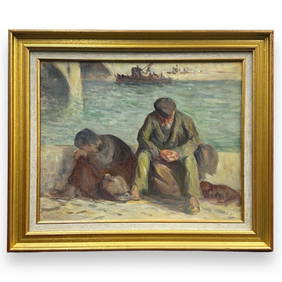
Maximilien Luce, (French, 1858-1941) oil on canvas. Two people with dog. Seascape with bridge andJoshua Kodner4.2(386)See Sold PriceMar 09, 2024
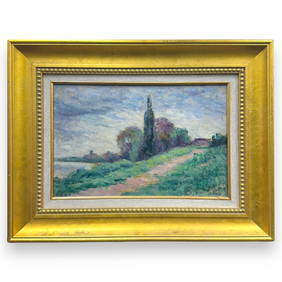
Maximilien Luce, (French, 1858-1941) oil canvas. signed lower right. "Landscape" water scene. datedJoshua Kodner4.2(386)See Sold PriceMar 09, 2024


![[ENSLAVEMENT & ABOLITION]. A group of 6 estate documents listing individual enslaved persons, most (1 of 13)](https://p1.liveauctioneers.com/197/319238/171468059_1_x.jpg?height=282&quality=70&version=1707520367)