MAP - PIETER SCHENK / VALK / JANSSEN Hand Colored superb Map Central Italy c1702Luis Porretta Fine Arts4.3(10)See Sold PriceMar 02, 2024
CHARLES ROLLIN c1828 Ceasar Hand Colored Africa Military MapLuis Porretta Fine Arts4.3(10)See Sold PriceMar 02, 2024
MAP - Dufour, A. H. ( Malte / Brun ) :MAP - ESPAGNE PARTIE SUD DIVISEE EN PROVINCES ANCIENNES ( MAPLuis Porretta Fine Arts4.3(10)See Sold PriceMar 02, 2024
RIGOBERT BONNE c1787 Original Colored Map Germany & Region 15" x 12"Luis Porretta Fine Arts4.3(10)See Sold PriceMar 02, 2024
AMBROISE TARDIEU c1822 Napoleonic War Map GermanyLuis Porretta Fine Arts4.3(10)See Sold PriceMar 02, 2024
MAP - AMBROISE TARDIEU c1822 Napoleonic Miltary Map GermanyLuis Porretta Fine Arts4.3(10)See Sold PriceMar 02, 2024
1822 Rare Map by Ambroise Tardieu Napoleon Caldiero Battle of Vento 17" x 11Luis Porretta Fine Arts4.3(10)See Sold PriceMar 02, 2024
PIETER SCHENK / VALK / JANSSEN Hand Colored Map of Rhodes Greece ca1702 vgcLuis Porretta Fine Arts4.3(10)See Sold PriceMar 02, 2024
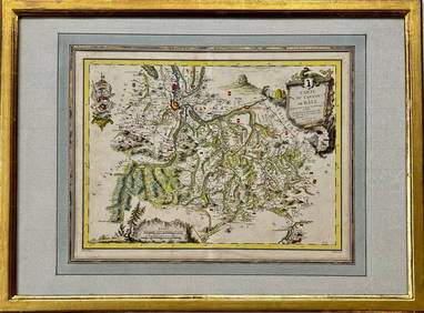
Map: Carte du Canton de Bale, Jacques Clermont, Paris, 1788Kensington Estate Auction4.6(216)See Sold PriceFeb 26, 2024
Map that brought the French into the AmericanDE LA TOUR, Louis Brion (c.1743-1803). Carte du Theatre de la Guerre entre les Anglais et les Americains... Engraved map with hand color. Paris: Esnauts & Rapilly, 1777 [but 1778]. 33 1/2" x 23 1/4" sSee Sold Price
Sold9 pieces. Engraved Maps - Egypt - French, British9 pieces. Engraved Maps - Egypt - French, British & American printings, ca. 1800-1830: Cook, John, pub. Plan du Kaie et de Environs." London, ca. 1802. Engraving. 10 1/2 x 14 3/8 inches (266 x 365 mm)See Sold Price
SoldFRENCH & AMERICAN PRINTED MAPS 19TH C.-20TH C. 3PCFRENCH & AMERICAN PRINTED MAPS, 19TH C.-20TH C., THREE, H 9 1/4"-14", W 9 1/2"-12 1/2":Including one French map of New Holland, measuring H. 14" x 9 3/4", circa late 19th Century; together with one maSee Sold Price
FRENCH & AMERICAN PRINTED MAPS 19TH C.-20TH C.FRENCH & AMERICAN PRINTED MAPS, 19TH C.-20TH C., THREE, H 9 1/4"-14", W 9 1/2"-12 1/2":Including one French map of New Holland, measuring H. 14" x 9 3/4", circa late 19th Century; together with one maSee Sold Price
SoldWilliam Faden (British, 1750-1836)French Map of American Territories by Sauthier & Ratzer circa 1776 Lithograph by William Faden In pencil "From original engraving by Faden London 1776" (upper left) Matted and framed. 30 x 21 inches.See Sold Price
10 Assorted Works, Prints & OriginalsIncludes two Toulouse Lautrec prints, French cartoon, vintage French maps of American territories originally by William Fadden, charcoal portrait of a girl, gouache of rider, and others. [Map frame: 3See Sold Price
Sold4 Maps: 1760 N. Am.; Botanic Geo.; Eur.; OK Terr.Four Antique Maps; a French 1760 Map of North American ''AMÉRIQUE SEPTENTRIONALE...1750'' Paris: S. Robert De Vaugondy, c. 1750 (1st edition, dated in the cartouche; "Outlines of Botanical Geography"See Sold Price
Framed Modern Hand-drawn Map Fragments RecountingFramed Modern Hand-drawn Map Fragments Recounting French Involvement in The American Revolution and Four Robert Dunning Chellis Illustrated Coast of Maine Chart Prints, the four unframed.See Sold Price
SoldLOT OF WWII MEMORABILIAIndian Engraved chrome Cigarette Case showing map from Baluchistan to French Indo-China, map, American flag and campaign ribbons inside; PLUS Same with polychrome 20 year calendar 1945-1964, Taj MahalSee Sold Price
SoldFrench Map of Mississippi, 1825Antique French Map of Mississippi, "Carte Geographique, Statistique et Historique du Mississipi", 1825, hand-colored engraved map from the French edition of Cary & Lea's American Atlas, sheet 21 in. xSee Sold Price
SoldMyra Z Barnes: Vintage Map French Quarter, New OrleansTitle/Content of Map: 1942 Myra Z Barnes Map of French Quarter, New Orleans -- Le Vieux Carre de la Nouvelle Orleans Date Printed: 1942 Cartographer: Myra Z Barnes Size: 20.5 X 30.8 A very attractiveSee Sold Price
Sold4Pcs ANTIQUE SOUTHERN US MAPS Civil War Antietam4Pcs ANTIQUE SOUTHERN US MAPS Civil War Antietam Sharpsburg Vicinity Topographical Battle Field General Doubleday Plan Siege of Savannah French & American 1779 Color Johnson′s Florida 1863 CSee Sold Price
Bonne: Antique Map of French Guyana & Surinam, 1727Map: French Guyana & Surinam Date Printed: 1727-95 Cartographer: Rigobert Bonne Material/Medium: Paper Size: 9 3/4" x 15" Copperplate engraving. Printed in Paris. From the 'Atals Portatit'. Rigobert BSee Sold Price
Sold1760 French + Indian War Map Louisiana + FloridaHistoric Maps French & Indian War Era Map of Louisiana & Florida c. 1760 French & Indian War Era, Historic Map Titled, “Carte de la Louisiane, et de la Floride. Par M. Bonne, Ingenieur-Hydrographe dSee Sold Price
SoldBarthélémy Lafon (French/American, 1769-1820)Barthélémy Lafon (French/American, 1769-1820), "Plan de l'Habitation de Mr. Michel Dragon arpentee par ordre de B. Lafon Ing., le mois de decembre, 1815", watercolor and ink manuscript map, 13 1/2 iSee Sold Price
SoldFrench & Indian War Period Map - Port of BostonHistoric Maps French & Indian War Period Map of the Port of Boston 1763 Map of the Port of Boston, "Carta Rappresentante il Porto di Boston," Engraved by G. M. Terreni, Choice Crisp Near Mint. This hiSee Sold Price
SoldMyra Z Barnes Map of French Quarter, New Orleans,1942Title: 1942 Myra Z Barnes Map of French Quarter, New Orleans Cartographer: Myra Z Barnes Published: 1942 or later Measurements: 20.5 X 30.8 in. Le Vieux Carre de la Nouvelle Orleans. A very attractiveSee Sold Price
SoldMyra Z Barnes: Map of French Quarter, New Orleans, 1942Map: 1942 Myra Z Barnes Map of French Quarter, New Orleans -- Le Vieux Carre de la Nouvelle Orleans Cartographer: Myra Z Barnes Year / Place: 1942 Map Dimensions: 20.5 X 30.8 Condition: Very Good. CriSee Sold Price
Bellin: Antique French Map Plan of Boston, 1757Title/Content of Map: Antique French Map and Plan of Boston, Massachusetts. Plan de la Ville de Boston et ses Environs Date Printed: 1757 Cartographer: Bellin, Jacques Nicolas Size (inches): 10 x 6 OnSee Sold Price
Barnes: Vintage Map of French Quarter New Orleans, 1942Title/Content of Map: 1942 Myra Z Barnes Map of French Quarter, New Orleans -- Le Vieux Carre de la Nouvelle Orleans Date Printed: 1942 ca. Cartographer: Myra Z Barnes Size: 20.5 X 30.8 in. A very attSee Sold Price
Myra Z Barnes: Map of French Quarter, New Orleans, 1942Map: 1942 Myra Z Barnes Map of French Quarter, New Orleans -- Le Vieux Carre de la Nouvelle Orleans Cartographer: Myra Z Barnes Year / Place: 1942 Map Dimensions: 20.5 X 30.8 inches Condition: Very GoSee Sold Price
SoldAntique French Map and Plan of Boston, MassachusettsTitle/Content of Map: Antique French Map and Plan of Boston, Massachusetts Date Printed: 1757 Cartographer: Bellin, Jacques Nicolas Size (in): 10 x 6 One of the earliest obtainable town plans of BostoSee Sold Price
Bellin: Antique Map of French Florida, 1756Map: Karte von den Kusten des Franzoisischen Florida Cartographer: Bellin Place & Date: Leipzig / 1756 Size: 5 3/4" x 8" Condition: b&w; light overall age toning Bellin's very interesting map of the cSee Sold Price
SoldBarnes: Antique Map of French Quarter, New Orleans 1942Title/Content of Map: 1942 Myra Z Barnes Map of French Quarter, New Orleans -- Le Vieux Carre de la Nouvelle Orleans Date Printed: 1942 Cartographer: Myra Z Barnes Size: 20.5 X 30.8 in. Condition: VerSee Sold Price
18TH C. ANTIQUE MAP: FRENCH & INDIAN WAR, FRAMEDThomaston Place Auction Galleries4.4(386)See Sold PriceFeb 24, 2024
French American Maurice de Vlaminck 1876-1958 Watercolor PaintingRbfinearts4.4(571)See Sold PriceFeb 24, 2024
FRENCH EXPRESSIONIST OIL PAINTING BY BERNARD LAMOTTEAntique Arena Inc.4.5(852)See Sold PriceFeb 24, 2024
SURREAL AMERICAN FRENCH BRONZE SCULPTURE BY MAN RAYAntique Arena Inc.4.5(852)See Sold PriceFeb 24, 2024
CUBIST AMERICAN PROFILE BRONZE SCULPTURE BY MAX WEBERAntique Arena Inc.4.5(852)See Sold PriceFeb 24, 2024
Armand Pierre Fernandez (Arman) (French-American, 1928-2005) Bronze "Telemann" ViolinMagnusson Art Group4.5(46)See Sold PriceMar 14, 2024
Catesby, Folio - American Goldfinch with Acacia. 1-43Trillium Antique Prints & Rare Books4.5(30)See Sold PriceFeb 24, 2024
Catesby, Folio - American Partridge with Attamusco Lily. Sup-12Trillium Antique Prints & Rare Books4.5(30)See Sold PriceFeb 24, 2024
YAACOV AGAM SIGNED JUDAICA OP ART HOLOGRAM AGAMOGRAPHAntique Arena Inc.4.5(852)See Sold PriceMar 02, 2024
12" x 14" February Moon Framed Picture by Betty AlbertWeatherham Estate Treasures3.9(157)See Sold PriceMar 21, 2024
12" x 14" The Rainmaker Framed Picture by Betty AlbertWeatherham Estate Treasures3.9(157)See Sold PriceMar 21, 2024
12" x 14" Family Framed Picture by Betty AlbertWeatherham Estate Treasures3.9(157)See Sold PriceMar 21, 2024
24.5" x 30" Limited Edition Motherhood by Betty Albert Framed PrintWeatherham Estate Treasures3.9(157)See Sold PriceMar 21, 2024
12" x 14" April Moon Framed Picture by Betty AlbertWeatherham Estate Treasures3.9(157)See Sold PriceMar 21, 2024
Ray H. French (American) Etching And Embossing on Paper Ca. 1970, "Stars & Stripes", H 10.5" WDuMouchelles4.6(825)See Sold PriceMar 15, 2024