SoldMap, Stanford's Library Map of LondonFramed map, Stanford's Library Map of London and its Suburbs (Sheet 7), published by Edward Stanford in London, 1877, plate inscribed with publication information lower center, overall: 21''h x 23''w.See Sold Price
SoldTwo Framed Maps: ''Stanford's Library Map of London andTwo Framed Maps: ''Stanford's Library Map of London and It's Suburbs'' and ''Essex'' by Robt. Morden.See Sold Price
SoldStanford's Library map of London. Kensington ChelseaReserve Reduced! TITLE/CONTENT OF MAP: 'Stanford's Library map of London and its suburbs [Sheets 9, 10, 13 & 14]' DATE PRINTED: 1877 IMAGE SIZE: Approx 65.0 x 82.0cm, 25.5 x 32.25 inches (Large); PleaSee Sold Price
SoldStanford's Library map of London. Marylebone NottingReserve Reduced! TITLE/CONTENT OF MAP: 'Stanford's Library map of London and its suburbs [Sheets 5, 6, 9 & 10]' DATE PRINTED: 1877 IMAGE SIZE: Approx 65.5 x 82.0cm, 25.75 x 32.25 inches (Large); PleasSee Sold Price
SoldStanford (Edward) - Stanford's Library Map of Londonlarge folding engraved map in 4 parts, each dissected and linnen-backed, hand-coloured in outline, light finger soiling and dusting, blue and gold paper covers with index map labels, each sheet measurSee Sold Price
SoldStanford Library Map of London & its SuburbsStanford (Edward) Stanford's Library Map of London and its Suburbs,large scale map from Hornsey to South Norwood, and from Hammersmith to Greenwich, engraved map with original hand-colouring,See Sold Price
SoldStanford (Edward). Stanford's Library Map of London andStanford (Edward) Stanford's Library Map of London and its Suburbs, large engraved map with hand-colouring, on four sheets, each dissected and linen-backed with marbled ends and index map labels, eachSee Sold Price
Stanford (Edward) Stanford's Library Map of LondonStanford (Edward) Stanford's Library Map of London and its Suburbsincluding detailed depictions of all the main parks including Crystal Palace in Sydenham Hill, engraved map with hand-colourinSee Sold Price
SoldStanford's Library Map of Londonand Its Suburbs circa 1871, engraved folding maps, hand-colored, on four large folding sheets, dissected and laid onto linen, front and back covers with marbled paper and paper labels, housed in a fulSee Sold Price
Sold-. Stanford (Edward) Stanford's Library Map of Lon-. Stanford (Edward) Stanford's Library Map of London and its Suburbs,engraved folding map, hand coloured, on 4 sheets, dissected and laid to linen, 1880 x 1740mm, [c.1871 or later].See Sold Price
SoldBLON Stanford (Edward) Stanford's Library Map of LBLON Stanford (Edward) Stanford's Library Map of London and its Suburbsincluding detailed depictions of all the main parks including Crystal Palace in Sydenham Hill, engraved map with hand-colSee Sold Price
SoldA framed detailed map of Kensington, London. Sheet 9A framed detailed map of Kensington, London. Sheet 9 (of 24) of Stanford's Library Map of London and its Suburbs. Approx. 15 1/4'' x 19''See Sold Price
SoldStanford (Edward) 24 engraved sheets on the scaleStanford (Edward) Stanford's Library Map of London and Its Suburbs, 24 engraved sheets on the scale of six inches to a mile, with key map as front paste-down, each c.360 x 435mm., first sheetSee Sold Price
SoldStanford (E) Library Map of LondonStanford (Edward) Library Map of London and its Suburbs, 4 folding engraved linen-backed maps, each dissected into 20 sections with part original hand-colouring, each opening to 980 x 850mm.,See Sold Price
SoldStanford (Edward) Library Map of LondonStanford (Edward) Library Map of London and its Suburbs, upper 2 sheets only, of 4, from Crouch End to Lambeth Bridge, and from Kensal Green to West Ham, showing the International Exhibition,See Sold Price
[MAPS, AUSTRALIA] Stanford's Library Map of Australasia constructed by A. Keith JohnstonA. Keith Johnston Stanford's Library Map of Australasia constructed by A. Keith Johnston London: Edward Stanford, 1863.155cm x 174cm folding to 27.5cm x 23cm. Hand coloured steel engraved map, dissectSee Sold Price
[MAPS, AUSTRALIA] Stanford's Library Map of Australasia constructed by A. Keith JohnstonA. Keith Johnston Stanford's Library Map of Australasia constructed by A. Keith Johnston London: Edward Stanford, 1863.155cm x 174cm folding to 27.5cm x 23cm. Hand coloured steel engraved map, disSee Sold Price
SoldStanford (Edward) Stanford's Library Map of AsiaStanford (Edward) Stanford's Library Map of Asia,engraved map on 4 sheets, disected onto linen, outline colouring, [c.1895] 1480 x 1600mm § Keller's Road Map of Switzerland, engraved map, dissSee Sold Price
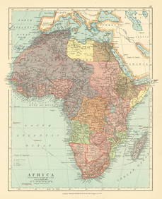
Sold(AFRICA.) Stanford, Edward. Stanford's Library Map of(AFRICA.) Stanford, Edward. Stanford's Library Map of Africa. New Edition, 1892. Large lithographed case map of Colonial Africa in 4 sections, each segmented and mounted to original linen with marbledSee Sold Price
Sold-. Stanford (Edward) Stanford's Library Map of Aus-. Stanford (Edward) Stanford's Library Map of Australasia,Constructed by A. Keith Johnston F.R.S.A., F.R.G.S., 1st edition wall map from Borneo to New Zealand, with inset chart of the world sSee Sold Price
SoldJohnston (Alexander Keith) Stanford's Library MapJohnston (Alexander Keith) Stanford's Library Map of Europe,engraved map, original hand-colouring, dissected and linen-backed, 1560 x 1730mm., original blind- and gilt-stamped cloth, sunned, 4See Sold Price
SoldPhilips New Library Map of London and its Environs,Philips New Library Map of London and its Environs, folding map, George Philip & Son, London, The London Geographical Institute, 152cm x 117cm - Stock Ref:6678-1See Sold Price
STANFORD, EDWARD. Stanford's Library Map of the WorldSTANFORD, EDWARD. Stanford's Library Map of the World on Mercator's Projection. Large lithographed case map of the world. 38x68 inches overall, dissected into 40 segments and mounted to original linenSee Sold Price
SoldSTANFORD, EDWARD. Stanford's Library Map of the WorldSTANFORD, EDWARD. Stanford's Library Map of the World on Mercator's Projection. Large lithographed case map of the world. 38x68 inches overall, dissected into 40 segments and mounted to original linenSee Sold Price
Africa. Congo Free Trade Area. British South Africa Company. STANFORD 1896 mapJasper524.5(9.9k)See Sold PriceFeb 28, 2024
Central Africa. Congo Free State Rhodesia German East Africa. STANFORD 1896 mapJasper524.5(9.9k)See Sold PriceFeb 28, 2024
Africa. French West/Equatorial. Tanganyika Belgian Congo. STANFORD c1925 mapJasper524.5(9.9k)See Sold PriceFeb 28, 2024
Africa. Congo Free Trade Area. British South Africa Company. STANFORD 1894 mapJasper524.5(9.9k)See Sold PriceFeb 28, 2024
Northwest Africa. Morocco Sahara Rio do Oro Ain Sefra Gardaia. STANFORD 1904 mapJasper524.5(9.9k)See Sold PriceFeb 28, 2024
Stanford, Edward 1901 Large Map. Burma and Adjacent CountriesAlbion Auctions4.7(341)See Sold PriceMar 01, 2024
Stanford, Edward 1901 Large Map. Sea of Marmara. TurkeyAlbion Auctions4.7(341)See Sold PriceMar 01, 2024
Stanford, Edward 1901 Large Map. Geological Map of the British IslesAlbion Auctions4.7(341)See Sold PriceMar 01, 2024
Stanford, Edward 1901 Large Map. Hydrographical Map of the British IslesAlbion Auctions4.7(341)See Sold PriceMar 01, 2024
Stanford, Edward 1901 Large Map. Stereographical Map of The British IslesAlbion Auctions4.7(341)See Sold PriceMar 01, 2024


![[MAPS, AUSTRALIA] Stanford's Library Map of Australasia constructed by A. Keith Johnston (1 of 8)](https://p1.liveauctioneers.com/8597/296734/157735915_1_x.jpg?height=282&quality=70&version=1690170365)
![[MAPS, AUSTRALIA] Stanford's Library Map of Australasia constructed by A. Keith Johnston (1 of 8)](https://p1.liveauctioneers.com/8597/288240/152537442_1_x.jpg?height=282&quality=70&version=1683682013)