Map 'Portugalliae at Algarbiae', 17th centuryMap of Portugal and Algarve 'Novissima Regnorum Portugalliae et Algarbiae descriptio entendata a F. de Wit', published by DE WIT F., Amsterdam, c.1680. Framed. Dim.:58,5x48,5cm.See Sold Price
SoldVISSCHER. Portugalliae et Algarbiae RegnaVISSCHER, Nicolaum. Portugalliae et Algarbiae Regna. 17th century. Engraved map, hand-coloured. Framed. 45.8cm x55.7cm (18" x 22")See Sold Price
SoldHomann 1736 Map of Portugal"Regnum Portugalliae Divisum in Quinque Provincais majores & Subdivisum in sua quaeque Territoria una cum Regna Algarbiae." 18th century map by Johann Baptist Homann with fully engraved mountains, forSee Sold Price
Homann 1736 Map of PortugalDESCRIPTION: "Regnum Portugalliae Divisum in Quinque Provincais majores & Subdivisum in sua quaeque Territoria una cum Regna Algarbiae." 18th century map by Johann Baptist Homann with fully engraved mSee Sold Price
SoldJohannes Mejer Map 17th CenturyJohannes Mejer full color map copperplate engraving. 17tth Century. Dithmarsle Pars Australis. Published Amsterdam 1663. Appears to be from The Atlas Maior published between 1662 and 1672. Measures 20See Sold Price
Antique Maps 17th Century ParisAntique Maps. Appear to be etched in the 17th Century. Map edges are quite worn, one has a large chip out of the upper right. Various makers. This item is from the estate of a gentleman from Gaton LamSee Sold Price
Antique Map 17th CenturyAntique Map Lot. This item is from the estate of a gentleman from Gaton Lamps on Melrose Ave. Gaton Lamps worked on the interior of the White House with Jackie Kennedy. Two maps from the 17th Century,See Sold Price
Antique Map 17th Century Maps Lot Of 5Antique Maps.Lot of 5 maps are by various makes and have a range of condition issues. This item is from the estate of a gentleman from Gaton Lamps on Melrose Ave. Gaton Lamps worked on the interior ofSee Sold Price
Visscher. New World Map, 17th CenturyGiclee On Canvas - Visscher. New World Map, 17th CenturySee Sold Price
Visscher. New World Map, 17th CenturyArt Print on Canvas - Visscher. New World Map, 17th CenturySee Sold Price
SoldJohannes Mejer Map 17th CenturyJohannes Mejer full color map copperplate engraving. 17tth Century. Dithmarsle Pars Australis. Published Amsterdam 1663. Appears to be from The Atlas Maior published between 1662 and 1672. Measures 20See Sold Price
Coronelli: Antique Map of Island of Corfu Greece, 1686Title/Content of Map: 17th century map of the Island of Corfu, Greece. Isola di Corfu Date Printed: 1686 Cartographer: Coronelli, Vincenzo Size (inches): 7 x 5 Fine antique map of the Greek island ofSee Sold Price
SoldAbraham Ortelius, Acores Insulae map(Dutch, 1527-1598). Hand-colored copper engraved map, 17th century or later, 15 x 22 in., framedSee Sold Price
Map, Wagriae, Pars Septentrionalis, Johannes MejerAn antique map. 17th century. Titled Wagriae, Pars Septentrionalis cum praefectura Cismar et Oldenburgh, Author Johannes Mejer, Husumens Rega. Mayis. Mathematicus. A copperplate engraving in full coloSee Sold Price
SoldMap, Marchionatus Misniae una cum VoitlandiaAn antique map. 17th century, c.1630. Titled Marchionatus Misniae una cum Voitlandia by Dutch Cartographer, atlas maker and publisher Henricus Hondius. A copperplate engraving in full color. The sheetSee Sold Price
SoldMap, Comitatus Marchia et Ravensberg, BlaeuAn antique map. 17th century. Titled Comitatus Marchia et Ravensberg by Dutch Cartographer, atlas maker and publisher Willem Janszoon Blaeu (1571-1638). A copperplate engraving in full color. The sheeSee Sold Price
SoldMap, Principatus Anhaldinus et MagdeburgensisAn antique map. 17th century, c.1630, Titled Principatus Anhaldinus et Magdeburgensis, Archiepiccopatus, by Dutch Cartographer, atlas maker and publisher Jodocus Hondius (1563-1612). A copperplate engSee Sold Price
SoldJan JanssonJan Jansson A general Plott and description of the Fennes and surrounded grounds hand coloured engraved map, 17th century 43 x 55cm (17 x 21in)See Sold Price
SoldJan BlaeuJan Blaeu Nortfolcia; Norfolke hand coloured engraved map, 17th century, with Latin text verso 52 x 61½cm (20 x 24in)See Sold Price
SoldBlaeu, Jan 8 framed and glazed Scottish maps, 17thBlaeu, Jan 8 framed and glazed Scottish maps, 17th century Caricta Borealis, 51 x 62cm, a little foxing; Lidalia vel Lidisdalia Regio, 35 x 58cm, some browning; Sterlinensis Praefectura, 48 x 57cm, aSee Sold Price
SoldSaxton and KipSaxton and Kip Bedfordshire, Huntingdon and Northamptonshire three hand coloured engraved maps, 17th century 28 x 33cm approx. (3)See Sold Price
SoldMap of 17th Century Amerique Septentrionale,divisee en nes Principlaes Parties ou sont distingues les vins des autres Les Estats// Diedie au Roy, Hertbert Iaillot, handcoloured, framed, 47cm x 64cmSee Sold Price
SoldMAP OF 17TH CENTURY. AMERICA.AMERICA 1690. HAND COLORED WITH WONDERFUL VIGNETTES OF NEW YORK AND QUEBEC. 22 1/2" X 19". MAP APPEARS TO BE A LATER PRINTING.See Sold Price
SoldMAP OF 17TH CENTURY. HONDIUS.AMERICA. 19 1/2 X 14 1/2. HAND COLORED. FRAMED UNDER GLASS. APPEARS FINE. MAP APPEARS TO BE A LATER PRINTING.See Sold Price
17th Century Hand Colored Engraved Map of GermanyGlobal Auctions Company4.3(36)See Sold PriceMar 03, 2024
Willem Blaeu, Etc. 17th C. Antiquarian Maps, 2Auctions at Showplace4.6(731)See Sold PriceMar 17, 2024
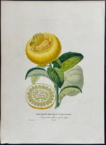
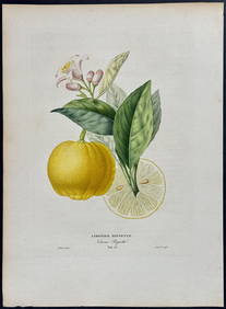
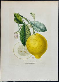
Risso - Lemon or Citrus Fruit. 73Trillium Antique Prints & Rare Books4.5(30)See Sold PriceFeb 24, 2024
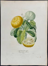
Risso - Lemon or Citrus Fruit. 71Trillium Antique Prints & Rare Books4.5(30)See Sold PriceFeb 24, 2024
WEST AFRICA Niger/Gambia rivers tribes towns. 'Pays des Negres'. MALLET 1683 mapJasper524.5(9.8k)See Sold PriceFeb 28, 2024
WEST AFRICA. Guinea. Nigeria Ghana Benin Togo Sierra Leone. MALLET 1683 mapJasper524.5(9.8k)See Sold PriceFeb 28, 2024
WEST CENTRAL AFRICA. Congo Angola Gabon Cameroon Sao Tome. MALLET 1683 old mapJasper524.5(9.8k)See Sold PriceFeb 28, 2024
NORTH AFRICA. 'Biledulgerid', a former North African country. MALLET 1683 mapJasper524.5(9.8k)See Sold PriceFeb 28, 2024
WEST AFRICA/MAGHREB Tribes Garamantes Getgulie 'Ancienne Libye'. MALLET 1683 mapJasper524.5(9.8k)See Sold PriceFeb 28, 2024
MALLET. Description de l'Univers. Africa. Volume 3 title page. MALLET 1683Jasper524.5(9.8k)See Sold PriceFeb 28, 2024
NORTH AFRICA. Barbary. Morocco Tunisia Libya Egypt. 'Barbarie'. MALLET 1683 mapJasper524.5(9.8k)See Sold PriceFeb 28, 2024
NORTH AFRICA. Morocco Tunisia Libya. 'Mauritanie'. Malta Melita. MALLET 1683 mapJasper524.5(9.8k)See Sold PriceFeb 28, 2024
NUBIA. 'Nubie'. Nile Valley. Sudan Ethiopia Egypt. MALLET 1683 old antique mapJasper524.5(9.8k)See Sold PriceFeb 28, 2024
SUB-SAHARAN AFRICA. 'Ancienne Ethiopie'. Ancient Ethiopia. MALLET 1683 old mapJasper524.5(9.8k)See Sold PriceFeb 28, 2024
JOHN LIGHTFOOT'S 1675 HORAE HEBRAICAE AND TALMUDICAE IS AN OLD JUDAICANY Elizabeth 4.3(85)See Sold PriceMar 03, 2024
ANTIQUE 1686 OPERA OMNIA BY JOHN LIGHTFOOT TELLIMA BOUND FOLIO WITH ISRAEL MAPNY Elizabeth 4.3(85)See Sold PriceMar 03, 2024
1675: ANTIQUE ILLUSTRATED JULIUS CAESAR MAPS OF ROMAN HISTORYNY Elizabeth 4.3(85)See Sold PriceMar 03, 2024
CURTIUS RUFUS QUINTUS, SIXTEENTH-CENTURY ELZEVIER HISTORIARUM LIBRI W/ MAP 16.33NY Elizabeth 4.3(85)See Sold PriceMar 03, 2024
Set of 6 Lithograph Prints of Dalarna Cabinets, Nordic Textiles, and Baroque Elegance - 1800sProverde Auctions4.3(3)See Sold PriceFeb 28, 2024