Map or Red Sea & adjacent areas 1720Heading: (Middle East - Red Sea) Author: Mortier, Pierre Title: Carte Particuliere de la Mer Rouge &c. Place Published: Amsterdam Publisher: Date Published: 1720 Description:See Sold Price
MAP, Red Sea, MortierRed Sea. Pierre Mortier, Carte des Principales Ports de Mer Bancs de Sable, &c: qui sont dans la Mer Rouge..., from Neptune Francais, 1720 (circa). Hand Color. The bays and safe anchorages in the RedSee Sold Price
Stow/Strype: Antique Map of Cheape Ward, London 1720TITLE/CONTENT OF MAP: 'Cheape Ward' This map shows Cheapside, Poultry and the adjacent area including King Street, Queen Street, Bucklersbury, Old Jewry, Bow Lane, St Mary Bow church, the Guildhall &See Sold Price
SoldAntique Map: Plan de la Rade de Gedda situee de la CoteChart of the area around city of Gedda in the Red Sea. D'AprŠs De Mannevillette (1707-1780) was one of Franc's first hydrographers. When the first edition of his Atlas Le Neptune Oriental (containiSee Sold Price
SoldAntique Map: RED SEA: KARTE DES ARABISCHEN MEERBUSENSMap with original decorative colour in outline shows the Red Sea. With an in-set map of the Gulf of Suez. Marked are towns, cities ports and smaller regions.The author Carsten Niebuhr (1733 - 1815) waSee Sold Price
SoldMAP, Red Sea, LangenesRed Sea. Barent Langenes, Mare Rubrum, from Thresor de Chartes, 1600 (published). Hand Color. This miniature map centers on the Red Sea and spans from Suez down to Zaila in present-day Somalia. It feaSee Sold Price
MAP, Red Sea, LangenesRed Sea. Barent Langenes, Mare Rubrum, from Thresor de Chartes, 1600 (published). Hand Color. This miniature map centers on the Red Sea and spans from Suez down to Zaila in present-day Somalia. It feaSee Sold Price
Soldd'Anville: Antique Map of the Red Sea & Islands, 1789Map: Red Sea & It's Islands Date Printed: 1789 Cartographer: Harrison D' Anville Material/Medium: Paper Size: 15" x 21" Condition: Very Good. Small tear on top. Tear does not affect the Map. Printed iSee Sold Price
Red Sea. Bab-el-Mandeb strait.Admiralty nautical seaReserve Reduced! TITLE/CONTENT OF MAP: 'Red Sea - Jebel Teir to Perim Island' DATE: Surveyed 1877-1919; Published 1882; Revised to 1930 IMAGE SIZE: Approx 91.5 x 100.5cm, 36 x 39.75 inches (Large); PlSee Sold Price
Admiralty nautical sea chart of the Red Sea, 1930TITLE/CONTENT OF MAP: 'Red Sea - Jebel Teir to Perim Island' DATE PRINTED: Surveyed 1877-1919; Published 1882; Revised to 1930 IMAGE SIZE: Approx 91.5 x 100.5cm, 36 x 39.75 inches (Large); Please noteSee Sold Price
Red Sea. Jebel Teir - Perim Island nautical chart 1930TITLE/CONTENT OF MAP: 'Red Sea - Jebel Teir to Perim Island' DATE PRINTED: Surveyed 1877-1919; Published 1882; Revised to 1930 IMAGE SIZE: Approx 91.5 x 100.5cm, 36 x 39.75 inches (Large); Please noteSee Sold Price
Red Sea. Jebel Teir Perim Island. Admiralty nauticalTITLE/CONTENT OF MAP: 'Red Sea - Jebel Teir to Perim Island' DATE PRINTED: Surveyed 1877-1919; Published 1882; Revised to 1930 IMAGE SIZE: Approx 91.5 x 100.5cm, 36 x 39.75 inches (Large); Please noteSee Sold Price
MAP, Arabia, Red Sea, East Africa, JaillotArabia, Red Sea, East Africa. Jaillot/Mortier, Carte Particuliere de la Mer Rouge &c. Leve par Ordre Expres des Roys de Portugal sous qui on en a Fait la Decouverte, 1700 (circa). Hand Color. This bolSee Sold Price
MAP - Arabia, Red Sea. Jaillot/MortierArabia, Red Sea, East Africa. Jaillot/Mortier, Carte Particuliere de la Mer Rouge &c. Leve par Ordre Expres des Roys de Portugal sous qui on en a Fait la Decouverte, 1700 (circa). Hand Color. This bolSee Sold Price
Sold[ASIA].[ASIA]. 4 Titles. Lon: Hakluyt Society. 8vo. Blue cloth (3 in dj). Very Good - Fine. ++ Joseph Pitts, et al. The Red Sea And Adjacent Countries At The Close Of The Seventeenth Century As Described BySee Sold Price
SoldOutstanding Nubian Ibex in Habitat Full Body Mount Taxidermy **TEXAS RESIDENTS ONLY!**The Nubian Ibex home range is the Red Sea Hills area in Israel and the Sinai Peninsula of Egypt.ÿ They are the smallest bodied of the World's Wild Ibex and one of the most beautiful.ÿ This one is aSee Sold Price
Bertius: Antique Map of the Red Sea, 1600Title: Mare Rubrum. Small 1600 map of the Red Sea with Egypt, Sudan, Saudi Arabia and Yemen Map maker: Petrus Bertius, Cornelium Nicolai Place and Year: Amsterdam, 1600 Dimensions: 11.5 x 16 cm (4.5 xSee Sold Price
SoldBellin: Antique Map of Arabia & Red Sea, 1728Map: 1728 Bellin Map of Arabia and Red Sea -- Carte de la Coste d'Arabie, Mer Rouge, et Golfe de Perse Cartographer: J Bellin Year / Place: 1740, Paris Dimensions: 8.6 x 9.8 in. Condition: Very good.See Sold Price
D'Anville: French Chart Map of the Red Sea, 1765Title: Golfe Arabique ou Mer Rouge...(French Chart of the Red Sea) Map maker: Jean Baptiste Bourguignon d'Anville Place and Year: Paris, 1765 Dimensions: 48.3 x 67 cm (19 x 26.4 in) Technique: CopperpSee Sold Price
1764 Bellin Map of the Red Sea Region -- Carte de laTitle/Content of Map: 1764 Bellin Map of the Red Sea Region -- Carte de la Mer Rouge et Partie de L'Arabie Date: 1764, Paris Cartographer: J Bellin Size: 8.5 X 14.2 in. This is a quite nice map of theSee Sold Price
1764 Bellin Map of the Red Sea Region -- Carte de laTitle/Content of Map: 1764 Bellin Map of the Red Sea Region -- Carte de la Mer Rouge et Partie de L'Arabie Date: 1764, Paris Cartographer: J Bellin Size: 8.5 X 14.2 in. This is a quite nice map of theSee Sold Price
Dudley Map of the Red SeaDudley, Robert (1532-1588). [Red Sea] Carta particolare...Baduis e finisce con il capo Cumana, e mostra la bocca dell mare Rosso. Engraved map. Florence: Onofri, 1646-47. 20 7/8” x 31 1/2” sheet.See Sold Price
Bonne: Map of Arabia, Red Sea & Persian Gulf, 1780Title/Content of Map: 'Carte de L'Arabie, du Golfe Persique et de la Mer Rouge, avec l'Egypte, la Nubie et l'Abissinie' A map of Arabia, the Nile valley & Abyssinia, with the Red Sea and Persian GulfSee Sold Price
1764 Bellin Map of the Red Sea Region -- Carte de laTitle/Content of Map: 1764 Bellin Map of the Red Sea Region -- Carte de la Mer Rouge et Partie de L'Arabie Date: 1764, ParisCartographer: J Bellin Size: 8.5 X 14.2 in. This is a quite nice map of theSee Sold Price
Collared Kingfisher Articulated Bird Skelton TaxidermyCircle M Auctions4.6(123)See Sold PriceMar 16, 2024
Natural History - Large Historic Cut & Polished Porphyry Slice.TimeLine Auctions Ltd.4.6(184)See Sold PriceMar 05, 2024
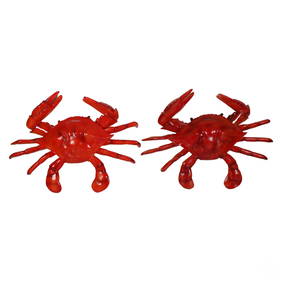
Pair of Gigantic 74" Deep Sea Red Crab SculpturesHill Auction Gallery 4.7(1k)See Sold PriceFeb 28, 2024
William Simpson's Sketches at the Seat of War - Two Volumes with 81 Hand-colored LithographsTrillium Antique Prints & Rare Books4.5(33)See Sold PriceFeb 24, 2024
A quantity of World War II / Two military ephemera to include assorted 1940s newspapers pages toClaydon Auctioneers Ltd4.3(125)See Sold PriceFeb 26, 2024
La Nubia ed Abissinia. Red Sea Ethiopia Sudan Eritrea Arabia. ZATTA 1785 mapJasper524.5(9.9k)See Sold PriceFeb 28, 2024
NILE VALLEY. Upper & Lower. Egypt Sinai Nubia Sudan Abyssinia. BLACKIE 1886 mapJasper524.5(9.9k)See Sold PriceFeb 28, 2024
NILE VALLEY. Upper & Lower. Egypt Sinai Nubia Sudan Abyssinia. BLACKIE 1882 mapJasper524.5(9.9k)See Sold PriceFeb 28, 2024
SOUTHERN AFRICA.Inset Ascension Is.; European colonies 1914;St Helena 1920 mapJasper524.5(9.9k)See Sold PriceFeb 28, 2024
4 Pieces of Black Sea Agate Cut & Polished SpecimensArtemis Fine Arts4.8(1.4k)See Sold PriceFeb 26, 2024
ISLAMIC FATIMID AL AZIZ NIZAR SILVER DIRHAM COINSAntique Arena Inc.4.5(883)See Sold PriceJun 15, 2024
ISLAMIC FATIMID AL AZIZ NIZAR SILVER DIRHAM COINSAntique Arena Inc.4.5(883)See Sold PriceJun 15, 2024


![[ASIA]. (1 of 0)](https://p1.liveauctioneers.com/dist/images/placeholder.jpg?height=282&quality=70)