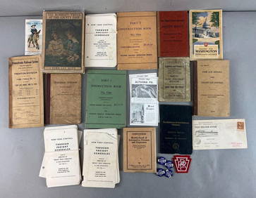
Timetable, Paper and Ephemera Lot-Eastern USA RailroadsJM Hobby Supply and Railroad Artifact Auctions4.4(127)See Sold PriceFeb 24, 2024
[BASEBALL]. Group of Varied Ephemera, including: Sporting L...Potter & Potter Auctions4.6(550)See Sold PriceMar 07, 2024
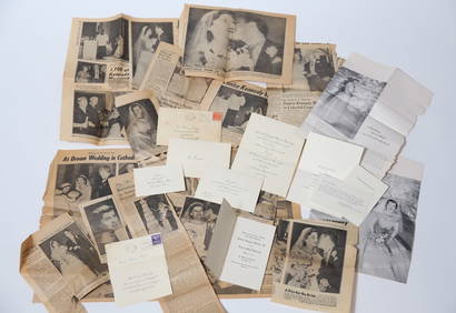
EPHEMERA from the MARRIAGE of MS. EUNICE KENNEDYJohn McInnis Auctioneers,LLC4.5(505)See Sold PriceFeb 25, 2024
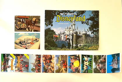
Rare Lot of 1965 and 1977 Walt Disneyland Collectible EphemeraSouth Florida Auction & Estate Sale Services Inc4.5(522)See Sold PriceMar 08, 2024
[CIGARETTE CARDS AND TOBACCO EPHEMERA]. A Group of Six Coll...Potter & Potter Auctions4.6(550)See Sold PriceMar 07, 2024
Group of MLB Ticket and Passes, Other Ephemera: American League Annual PassDana J. Tharp Auctions4.7(271)See Sold PriceFeb 24, 2024
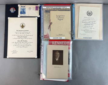
Group of US Presidents inauguration souvenirs, and EphemeraMatthew Bullock Auctioneers4.7(1.9k)See Sold PriceFeb 24, 2024
Map of the Yukon District in the North West TerritoryThis is sheet 3 map of the Yukon District in the North West Territory 1898, scale is 506, drawn by J. McEvoy. Highlighting White Horse township. Geologic features are numbered and highlighted in red wSee Sold Price
Map of the Yukon District in the North West TerritoryThis is sheet 3 map of the Yukon District in the North West Territory 1898, scale is 506, drawn by J. McEvoy. Highlighting White Horse township. Geologic features are numbered and highlighted in red wSee Sold Price
Sold[1832 MAP]40. [1832 MAP] A colorful German map of the Northern Part of the United States of North America, 1832. Bounded on the West by Missouri and the "Sioux District of the Missouri Territory" and on the SouSee Sold Price
SoldTallis/Rapkin: Antique Map of West Canada, 1849TITLE/CONTENT OF MAP: 'West Canada' The map shows the eastern part of modern Ontario, divided into districts/counties. Part of the map is shown as "Indian territory", with "Indian traders" marked. VigSee Sold Price
Tallis / Rapkin: Antique Map of West Canada, 1849Title/Content of Map: 'West Canada' The map shows the eastern part of modern Ontario, divided into districts/counties. Part of the map is shown as "Indian territory", with "Indian traders" marked. VigSee Sold Price
SoldLot of 5x 1992 Canada 25-cent ICCS Certified MS-64 -Lot of 5x 1992 Canada 25-cent ICCS Certified MS-64 - Quebec, Yukon, Northwest Territories, Ontario & Saskatchewan. 5pcsSee Sold Price
Sold1795 Joseph T. Scott's Map of Northwest Territoryfrom the United States Gazetteer. sight size: H6 1/4" W7 3/8"See Sold Price
Vitnage Rentschler Pictorial Map of Northwest TerritoryTitle/Content of Map: 1937 Rentschler Pictorial Map of the Northwest Territory -- How The United States Came Into The Possession Of Northwest Territory Date Printed: 1937 Cartographer: F Rentschler SiSee Sold Price
SoldNorth West Territories Rand, McNally & Co.'S NewTitle: North West Territories Rand, McNally & Co.'S New Business Atlas Map of North West Territories. Publication Date: 1898 Cartographer: RAND, MCNALLY & CO. Publisher: RAND, MCNALLY & CO. Size: 12.2See Sold Price
Sold1880's Hand Tinted Northwest Indian Tribe MapIncluded in this lot we have a hand tinted map of Northwest Native American Indian tribes originating from 1880's. The map details Northwest territories including Utah, Wyoming, and Montana. The map sSee Sold Price
Topographical Maps of the North West TerritoriesThis is a collection of 16 maps of the North West Territories in Canada: McKenzie River at Providence to Simpson, scale 1 in.=4 miles, inclination is about 37 degrees from TN and decreasing at 2 minutSee Sold Price
SoldTopographical Maps of the North West TerritoriesThis is a collection of 16 maps of the North West Territories in Canada: McKenzie River at Providence to Simpson, scale 1 in.=4 miles, inclination is about 37 degrees from TN and decreasing at 2 minutSee Sold Price
Map of the Northwest Territories.Title: Map of the Northwest Territories. Publication Date: 1874 Cartographer: STANFORD'S GEOGRAPHICAL ESTABLISHMENT Publisher: CHAPMAN & HALLSize: 11.5Height - 19Width Shows numerous forts in northwesSee Sold Price
Sold1833 North West and Michigan TerritoriesA wonderful map showing the North West Territory in what is now mostly Wisconsin, as well as the majority of the Michigan Territory. Published by Chapman and Hall on april 1st of 1833, the map lists aSee Sold Price
Sold1870's Northwest Territory Hand Tinted MapAvailable in this lot we have a hand tinted map of the Northwest Territories originating from the 1870's. The map details the Northwest territories including Washington, Oregon, Idaho, and most of MonSee Sold Price
Sold1890's Hand Tinted Northwest Territory MapFeatured in this lot we have a hand tinted Northwest US territory maps originating from the 1890's. The map details the Northwest territories including Wyoming, Idaho, and Montana. The map shows mountSee Sold Price
Sold1937 Rentschler Pictorial Map of the NorthwestTitle/Content of Map: 1937 Rentschler Pictorial Map of the Northwest Territory -- How The United States Came Into The Possession Of Northwest Territory Date: 1937 Cartographer: F Rentschler Size: 23 xSee Sold Price
Sold1860's Hand Tinted Northwest Territories MapIncluded in this lot is a hand color tinted map of the Northwest US territories originating from the 1860's. The The map details the Northwest territories including Washington, Oregon, Idaho, and mostSee Sold Price
Sold"THE OLD NORTHWEST TERRITORY" ILLUSTRATED MAP PRINT"THE OLD NORTHWEST TERRITORY" ILLUSTRATED MAP PRINT, colored offset lithograph, depicting the map of the Northwest territory "Preceding and Following the Ordinance of 1787" featuring several vignettesSee Sold Price
1937 Rentschler Pictorial Map of the NorthwestTitle/Content of Map: 1937 Rentschler Pictorial Map of the Northwest Territory -- How The United States Came Into The Possession Of Northwest Territory Date: 1937 Cartographer: F Rentschler Size: 23 xSee Sold Price
1937 Rentschler Pictorial Map of the NorthwestTitle/Content of Map: 1937 Rentschler Pictorial Map of the Northwest Territory -- How The United States Came Into The Possession Of Northwest Territory Date Printed: 1937 Cartographer: F Rentschler SiSee Sold Price
Sold6 CANADA TERRITORIES QUARTERS UNC ALBERTA, YUKON,ALBERTA, YUKON, MANITOBA, NEWFOUNDLAND, NORTHWEST TERRITORIES AND NEWBRUNSWICHSee Sold Price
Sold1833 MAP OF LAKE MICHIGAN & NORTH WEST TERRITORY 121833 MAP OF LAKE MICHIGAN & NORTH WEST TERRITORY 12 1/2" X 15" SITE SIZESee Sold Price
Map of Manitoba and North-West Territory (Dominion ofTitle: Map of Manitoba and North-West Territory (Dominion of Canada) 1905 Publication Date: 1905 Cartographer: ANONYMOUS Publisher: DEPARTMENT OF AGRICULTURE OF CANADA Size: 17.6 Height - 19.5 Width "See Sold Price
[ARCTIC]. BOWEN, Emanuel. A New & Accurate Map of the North...Potter & Potter Auctions4.6(550)See Sold PriceMar 07, 2024
Map: A 19thC engraved map of West Riding, titled A Map of the North Part of the West Riding ofClaydon Auctioneers Ltd4.3(125)See Sold PriceFeb 26, 2024
New and Correct Map of North America With the West India Islands,Jasper524.5(9.9k)See Sold PriceFeb 27, 2024
NORTHERN AFRICA. Morocco Tunisia Algeria. Caravan routes. RAPKIN/TALLIS 1851 mapJasper524.5(9.9k)See Sold PriceFeb 28, 2024
NORTH & WEST AFRICA. Sahara Niger river 'Zaara ou le Desert'. MALLET 1683 mapJasper524.5(9.9k)See Sold PriceFeb 28, 2024
AFRICA. French West Africa. Rio de Oro Rio Muni Nigeria. BARTHOLOMEW 1952 mapJasper524.5(9.9k)See Sold PriceFeb 28, 2024
WEST AFRICA. British Cameroons & Togoland mandates. Gold Coast Nigeria 1947 mapJasper524.5(9.9k)See Sold PriceFeb 28, 2024
NORTH & WEST AFRICA. Gold Coast (Ghana) Slave Coast. Tribal names 1890 mapJasper524.5(9.9k)See Sold PriceFeb 28, 2024
Northwest Africa. Morocco Sahara Rio do Oro Ain Sefra Gardaia. STANFORD 1904 mapJasper524.5(9.9k)See Sold PriceFeb 28, 2024
North-west Africa. Morocco &c. Sahara desert. Unresolved borders. TIMES 1922 mapJasper524.5(9.9k)See Sold PriceFeb 28, 2024
North & West Africa. Dahomey. Gold Coast. Military Territory. THE TIMES 1922 mapJasper524.5(9.9k)See Sold PriceFeb 28, 2024
Colonial Africa North-West. British French. Nigeria Sahara. THE TIMES 1895 mapJasper524.5(9.9k)See Sold PriceFeb 28, 2024
Afrique. Pays des Hottentots #51. Botswana South Africa. VANDERMAELEN 1827 mapJasper524.5(9.9k)See Sold PriceFeb 28, 2024
FRENCH WEST AFRICA Nigeria Gold Coast Rio de Oro Portuguese Guinea 1912 mapJasper524.5(9.9k)See Sold PriceFeb 28, 2024
Northwest Africa. Morocco Sahara Rio do Oro Ain Sefra Gardaia. STANFORD 1904 mapJasper524.5(9.9k)See Sold PriceFeb 28, 2024
West Africa. Sahara caravan routes. Tribes Kingdoms Empires. LIZARS 1842 mapJasper524.5(9.9k)See Sold PriceFeb 28, 2024
NORTHERN AFRICA. Morocco Tunisia Algeria. Caravan routes.TALLIS/RAPKIN 1851 mapJasper524.5(9.9k)See Sold PriceFeb 28, 2024
Colonial Africa North-West. British French. Nigeria Sahara. THE TIMES 1900 mapJasper524.5(9.9k)See Sold PriceFeb 28, 2024


![[BASEBALL]. Group of Varied Ephemera, including: Sporting L... (1 of 2)](https://p1.liveauctioneers.com/928/318880/171361366_1_x.jpg?height=282&quality=70&version=1707501302)

![[CIGARETTE CARDS AND TOBACCO EPHEMERA]. A Group of Six Coll... (1 of 1)](https://p1.liveauctioneers.com/928/318880/171361529_1_x.jpg?height=282&quality=70&version=1707501302)


![[1832 MAP] (1 of 1)](https://p1.liveauctioneers.com/135/375/187760_1_x.jpg?height=282&quality=70&version=1070305305)


![[ARCTIC]. BOWEN, Emanuel. A New & Accurate Map of the North... (1 of 1)](https://p1.liveauctioneers.com/928/318880/171360917_1_x.jpg?height=282&quality=70&version=1707501302)


