SoldMAP OF THE KINGDOM OF IRELAND BY J. ROCQUE, LONDONMAP OF THE KINGDOM OF IRELAND BY J. ROCQUE, LONDON printed for Robert Sayer, Fleet Street, framed 38.5in (98cm)h x 48.5in (123cm)w. (1)See Sold Price
SoldANTIQUE MAP, "KINGDOM OF IRELAND", JOHN ROCQUEANTIQUE MAP, "KINGDOM OF IRELAND", JOHN ROCQUE CIRCA 1790 23" X 38":Framed. Kingdom of Ireland divided into Provinces, Counties and Baronies, J Rocque, chorographer to his majesty. Adjoining sheets. HSee Sold Price
1760 map of Ireland, engraved, hand-col1760 map of Ireland, engraved, hand-colored in outline, four sheets in two sections, "A Map of the Kingdom of Ireland," Robert Sayer, London, tears and toning, unframed, 51-1/4 x 39"See Sold Price
SoldJ. Rocque, Laurie & Whittle, 1794. Map of IrelandJ. Rocque, Laurie & Whittle, 1794. pair of unframed coloured engravings, Map of Ireland, 24 x 38 ins.See Sold Price
SoldLyttleton, George 1810 Map of Ireland by J. RussellCopper Engraved Map Published 1810, London for "The History of England..." by George Courtney Lyttleton. Folds as issued. Paper Size: 17 x 15 inch (43 x 38cm) Approx. Very minor toning, good conditionSee Sold Price
SoldLyttleton, George 1810 Map of Ireland by J. RussellCopper Engraved Map Published 1810, London for "The History of England..." by George Courtney Lyttleton. Folds as issued. Paper Size: 16.5 x 13.5 inch (42 x 34cm) Approx. Tiny right tear in border. GoSee Sold Price
SoldLyttleton, George 1811 Map of Ireland by J. RussellCopper Engraved Map Published 1811, London for "The History of England..." by George Courtney Lyttleton. Folds as issued. Paper Size: 18.5 x 15.5 inch (47 x 39cm) Approx. Some wrinkles. Very minor tonSee Sold Price
SoldIreland.- Rocque (John) - A Map of the Kingdom oflarge 4-sheet map with title vignette of watering cattle and river nymph, upper left, inset map of the Sea Coasts of Great Britain and Ireland, lower right, text panels and compass rose, engraved mapSee Sold Price
SoldOakley Plan of QuebecA Plan of Quebec. Edward Oakley (fl. 1730-1766). Copperplate Engraving. London: J. Rocque, c. 1759. 15 1/4 x 21 1/2 inches sheet.See Sold Price
1753 Rocque Map of English Counties -- A parlimentaryTitle: 1753 Rocque Map of English Counties -- A parlimentary Map of England Date: 1753, London Cartographer: J Rocque Size: 9.1 X 11.4 in. Additional Information: This is fascinating item, showing theSee Sold Price
SoldA New and Accurate Map of the Kingdom of Ireland, FromHand-coloured map, taken from the Universal Magazine, 1799. Abl SG48. London: 1779. Hand-coloured map (30 cm. wide; 34 cm. high) of the whole country of Ireland. Good and clean. (1)See Sold Price
SoldRocque, John108. Rocque, John.A Map of the Kingdom of Ireland. Large engraved map of Ireland on 2 sheets. 48 x 38 inches, plus margins, outlined in color; margins frayed, several closed tears along folds, generalSee Sold Price
SoldJohn Rocque, Map of Ireland, Engraved, 1780John Rocque (1709-1762) , "A Map of the Kingdom of Ireland, divided into provinces, counties...", large two-sheet map from Sayer's "General Atlas", 1780, engraved with outline color, elaborate cartoucSee Sold Price
SoldRocque (John) A Map of the Kingdom of Ireland-. Rocque (John) A Map of the Kingdom of Ireland, large map of Ireland, on 4 sheets, joined, with original hand-colouring, large pictorial cartouche, inset map of the coasts of Great Britain aSee Sold Price
SoldJ. Roque Map of the Kingdom of Ireland & 2 othersJ. Roque unframed coloured engraving, Map of the Kingdom of Ireland, 23.5 x 38 ins. (top half only), a Thos. Kitchin Map of Northern Europe, 20 x 48 ins. and a G. & J. Cary map of Hastings - Romney, 2See Sold Price
1753 Rocque Map of English Counties -- A ParlimentaryTitle: 1753 Rocque Map of English Counties -- A Parlimentary Map of England Year/Place: 1753, London Cartographer: J Rocque Size: 9.1 X 11.4 in. Additional Information: This is fascinating item, showiSee Sold Price
SoldTwo Atlas Maps; Portugal and the AmericasLondon: J. Carey, 1825. A New Map of the Kingdom of Portugal, divided into its provinces from the latest authorities by John Carey, engraver. Copper plate engraved map with hand color on T.Edmonds watSee Sold Price
Irland: Map of the KingdomIrland. A New and Accurate Map of the Kingdom of Ireland ... Kupferstich mit figürlicher Kartusche und zeitgenöss. Grenzkolorit. 65,5 x 60 cm. By Thomas Jefferys. London Published ... 1759 ... AusgeSee Sold Price
SoldMap of Ireland in 1732Heading: Author: Seale, Richard William Title: A Map of the Kingdom of Ireland from ye Latest & Best Observations. For Mr. Tindal's Continuation of Mr. Rapin's History Place Published: London PublishSee Sold Price
Sold1783 Cary Map of Great Britain and Ireland -- A Map ofTitle: 1783 Cary Map of Great Britain and Ireland -- A Map of Great Britain and Ireland with all the Adjacent Isles. Year/Place: 1783, London Cartographer: J Cary Size: 10.8 X 8.8 in. Additional InforSee Sold Price
Sold[Maps] Camden's Britannia, 1789, Folio SetCamden, William. BRITANNIA: OR, A CHOROGRAPHICAL DESCRIPTION OF THE FLOURISHING KINGDOMS OF ENGLAND, SCOTLAND, AND IRELAND. London: John Nichols, 1789. 3 vols, folio, 16.75" x 10.25". viii, [2], xxii,See Sold Price
SoldSymes, Michael An Account of an Embassy to The KingdomSymes, Michael An Account of an Embassy to The Kingdom of Ava London: J. Debrett, 1800. Atlas volume only (i.e. lacking the two text volumes), 8vo, two folding maps, 26 plates (some folding), originalSee Sold Price
1873 Map of IrelandAuthor: Bartholomew Title: 1873 Map of Ireland Medium: Ink on Paper Dimensions: 14"X18.5" Map of Ireland dated 1873. Edited and by J.G. Bartholomew. Published by George Newnes in London. Part of the CSee Sold Price
HONEST JOHN OLIVER by James Morton 1st Edition Inscribed by Author ScarceLuis Porretta Fine Arts4.3(10)See Sold PriceMar 02, 2024
A J HANDFORD British Lithographer Rome from Mount Aventi Signed c1910 FramedLuis Porretta Fine Arts4.3(10)See Sold PriceMar 02, 2024
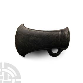
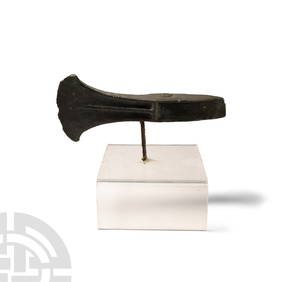
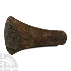
Bronze Age South-Eastern Type Looped and Socketted AxeheadTimeLine Auctions Ltd.4.6(182)See Sold PriceMar 05, 2024
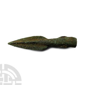
British Bronze Age Basal-Looped and Socketed SpearheadTimeLine Auctions Ltd.4.6(182)See Sold PriceMar 07, 2024
General Books - Rapin's History of England Plate Atlas in Royal BindingTimeLine Auctions Ltd.4.6(182)See Sold PriceMar 08, 2024
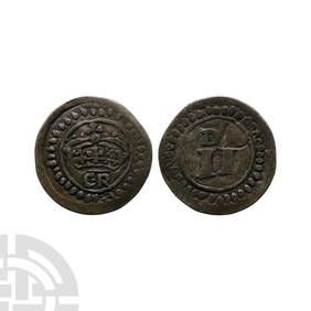
Irish Coins - Ireland - Contemporary Forgery - AR Ormonde Besieged TwopenceTimeLine Auctions Ltd.4.6(182)See Sold PriceMar 09, 2024
Portfolio of 15 County Maps by Robert Morden (English 1650-1703)Nadeau's Auction Gallery4.7(405)See Sold PriceFeb 24, 2024
[MAP]. NICHOLLS, Sutton (1668-1729). An Epitome of Sr. Will...Potter & Potter Auctions4.6(544)See Sold PriceMar 07, 2024
J HARRIS AFTER MICHAEL ANGELO HAYES A set of 6 prints 'Car-Travelling in the South of Ireland in theAdam's Auctioneers4.3(5)See Sold PriceFeb 27, 2024
Clarke & Neele 1815 Map. Europe - Recent Political ChangesAlbion Auctions4.6(341)See Sold PriceMar 01, 2024
William Bromley III (NJ,Irish,UK,1835-1888) oil painting antiqueBroward Auction Gallery4.8(285)See Sold PriceMay 19, 2024
Joseph Williamson Ludlow (1840 - 1916) - Set of 2 Bird Prints - Aylesbury Ducks - Toulouse GeeseProverde Auctions4.3(3)See Sold PriceFeb 28, 2024
Joseph Williamson Ludlow (1840 - 1916) - Set of 2 Bird Prints - White-faced black Spanish - WhiteProverde Auctions4.3(3)See Sold PriceFeb 28, 2024
Antique Map - Views on the coast of Asia. J. Webber del. Engraved after J. Webber and W. Bligh.Proverde Auctions4.3(3)See Sold PriceFeb 28, 2024


![[Maps] Camden's Britannia, 1789, Folio Set (1 of 6)](https://p1.liveauctioneers.com/3532/154050/77745056_1_x.jpg?height=282&quality=70&version=1572759985)


![[MAP]. NICHOLLS, Sutton (1668-1729). An Epitome of Sr. Will... (1 of 1)](https://p1.liveauctioneers.com/928/318880/171361281_1_x.jpg?height=282&quality=70&version=1707501302)


