SoldMap of Public Surveys, Washington Territory, 1863Anson L. Henry, surveyor general. Shows areas of gold mines, Steven’s proposed northern route of the Pacific Railroad, Na Chee Pass, Yakima Indian Reservation, surveys that have been executed aSee Sold Price
SoldMap of Public Surveys Washington TerritoryAmercia.- Map of Public Surveys Washington Territory to accompany Report of Surv: Genl: 1863,lithographic map, 430 x 540mm., four vertical folds, two horizontal folds, each reinforced verso, fSee Sold Price
SoldU.S. MAP WASHINGTON TERRITORY, ANSON HENRY, 1863"Map of Public Surveys, Washington Territory to accompany Report of Surv: Genl: 1863, Anson G. Henry, Surveyor General, Lith of J. Bien 24 Vesey St, NY", showing positions of Mt. Baker, Gold Mines, OlSee Sold Price
Map of Wisconsin & Territory of Minnesota, 1849Map: Public Surveys in the State of Wisconsin and Territory of MinnesotaPublisher: G.L.O., Washington DC, 1849 Size: Folio – 17.75 H x 22.50 W Inches Sparse topography and surveys. Slightly foxed. PSee Sold Price
Nevada Comstock Lode Map 1862Heading: (Nevada) Author: Beale, Edward Fitzgerald Title: Map of public surveys in Nevada Territory to accompany report of Surveyor Genl. 1862 Place Published: Washington, D.C. Publisher:[Government PSee Sold Price
Map of Wisconsin & Territory of Minnesota, 1854Map: A Sketch of the Public Surveys in Wisconsin and Territory of Minnesota Maker: General Land Office, Lewis, Warner Publisher: General Land Office 1854 Washington, DCSize: Folio – 17.50 H x 20.75See Sold Price
SoldLarge map of U.S. Surveys 1872Heading: (United States) Author: General Land Office Title: Map of the United States and Territories, Showing the Extent of Public Surveys and Other Details Place Published: Washington Publisher:See Sold Price
SoldMaps Including Mexican Boundary Survey & N.T.Mexican boundary surveys - 7 maps - 1851 and map of public survey in Nevada Territory - Surveyor General - 1862 (8 maps in the lot of varying size)See Sold Price
Survey map of Nevada 1862Title: Map of Public Surveys in Nevada Territory to accompany Report of Surveyor Genl. 1862 Author: Beale, E.F. Description: Lithographed map. 76x51 cm. (30x20").Early, perhaps the first, public surveSee Sold Price
Sold1862 MAP OF NEVADA TERRITORYFull title being: “Map of Public Survey in Nevada Territory to Accompany Report of Surveyor Genl. 1862”, by E.T. Bade, 21.5” x 31.5”.See Sold Price
SoldIowa Territory Public Survey Map For 26th CongressThis is a public survey map of the Iowa Territory. The top is marked "S. 26th con. 1st ses.", The 26th Congress 1st Session went from December 1839 to July 1840. The map is also marked "Sketch of TheSee Sold Price
SoldGLO Map of Washington Territory, ca 1860-61**Originally Listed At $100** Map of a Part of Washington Territory to Accompany the Report of the Surveyor General 1860-61. A very collectible early survey map of the Washington Territory that was coSee Sold Price
GLO Map of Washington Territory, ca 1860-61**Originally Listed At $100** Map of a Part of Washington Territory to Accompany the Report of the Surveyor General 1860-61. A very collectible early survey map of the Washington Territory that was coSee Sold Price
GLO Map of Washington Territory, ca 1860-61**Originally Listed At $100** Map of a Part of Washington Territory to Accompany the Report of the Surveyor General 1860-61. A very collectible early survey map of the Washington Territory that was coSee Sold Price
GLO Map of Washington Territory, ca 1860-61Map of a Part of Washington Territory to Accompany the Report of the Surveyor General 1860-61. A very collectible early survey map of the Washington Territory that was conducted under the supervisionSee Sold Price
SoldSketch of the Public Surveys in Wisconsin and TerritoryTitle/Content of Map: Sketch of the Public Surveys in Wisconsin and Territory of Minnesota Cartographer: LEWIS, WARNER Date: 1855 Publisher: SURVEYOR GENERALS' OFFICE Size: 17Height - 21Width SurveyorSee Sold Price
U.S. MAP OF KANSAS AND NEBRASKA TERRITORIES, 1860"Map showint the progress of Public surveys in the Territories of Kansas and Nebraska, to accompany the Annual Report of the Surveyor General, 1860, includes rivers and streams, many Indian reservatioSee Sold Price
SoldU.S. MAP OF KANSAS AND NEBRASKA TERRITORIES, 1860"Map showing the progress of Public surveys in the Territories of Kansas and Nebraska, to accompany the Annual Report of the Surveyor General, 1860, includes rivers and streams, many Indian reservatioSee Sold Price
SoldU.S. MAP OF KANSAS AND NEBRASKA TERRITORIES, 1860"Map showing the progress of Public surveys in the Territories of Kansas and Nebraska, to accompany the Annual Report of the Surveyor General, 1860, includes rivers and streams, many Indian reservatioSee Sold Price
Sold5 Antique Maps of New Mexico[Five Antique Maps of New Mexico], incl. "Sketch of Public Surveys of New Mexico", 1862; "Archaeological Map of Pajarito Park", 1900; "Sketch of Public Surveys...", 1861; "Territory of New Mexico", 18See Sold Price
SoldFive Maps of New Mexico[Five Antique Maps of New Mexico], incl: "Sketch of Public Surveys of New Mexico", 1862; "Archaeological Map of Pajarito Park", 1900; "Sketch of Public Surveys...", 1861; "Territory of New Mexico", 18See Sold Price
SoldWashington Gold Region Map #89921Framed map of Public Surveys to Accompany report of Surv: Genl: 1863. Litho of J. Bien. was creased with some crease toning. 19x23" State: Washington City: Date: 1863See Sold Price
Sold1853-1855 Jefferson Davis Railroad Survey Map"Milk R. to the Crossing of the Columbia R. from explorations & surveys made under the direction of Hon. Jefferson Davis, Secretary of War, by Isaac I. Stevens Gov. of Washington Territory 1853-4-5".See Sold Price
Northern Transcontinental Survey Maps, by RaphaelThis is a collection of four maps; one for the Forest Department, and three for the Agriculture Department of Washington Territory 1883, printed by Julius Bien by the authority of the Oregon & TranscoSee Sold Price
Rand McNally Railroad Map of Washington-1906JM Hobby Supply and Railroad Artifact Auctions4.4(126)See Sold PriceFeb 24, 2024
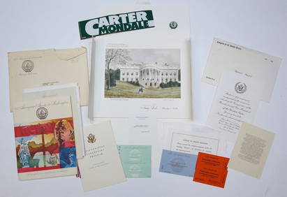
1977 INAUGURATION of PRESIDENT JIMMY CARTERJohn McInnis Auctioneers,LLC4.6(502)See Sold PriceFeb 25, 2024
Thirty Pieces of Lackawanna Railroad Ephemera - Chief Engineer Timebook, Map, Public Timetables,Rail & Road Auctions4.6(165)See Sold PriceMar 07, 2024
Francis McNally - Antique Map of Washington, Oregon, Idaho, Nevada, Utah & ArizonaProverde Auctions4.3(3)See Sold PriceFeb 28, 2024
C.1888 Tacoma Boudoir Card Waterfront by RutterGrant Zahajko Auctions, LLC4.8(1k)See Sold PriceMar 06, 2024
[Washington Territory, Lumber] Letterhead (7)Grant Zahajko Auctions, LLC4.8(1k)See Sold PriceMar 06, 2024
The Kingdom of Dalmatia Territories Map, 1700Antiques Online Auctions4.6(407)See Sold PriceMar 14, 2024


![[Washington Territory, Lumber] Letterhead (7) (1 of 5)](https://p1.liveauctioneers.com/5755/320282/172114106_1_x.jpg?height=282&quality=70&version=1708463029)


