Marc Chagall-Limited Edition -Paris Opera Ceiling after ChagallArt Legacy Auctions4.5(217)See Sold PriceFeb 24, 2024
Salvador Dali Pantagruel Limited Edition Lithograph Hand signed and numberedArt Legacy Auctions4.5(217)See Sold PriceFeb 24, 2024
Pablo Picasso Bouquet of Peace Collection Domaine Picasso Limited Edition on paper.Art Legacy Auctions4.5(217)See Sold PriceFeb 24, 2024
A RARE MAXFIELD PARRISH JACK AND THE BEANSTALK PRINTSoulis Auctions4.8(953)See Sold PriceFeb 24, 2024
LARGE MECHANICAL PRINT 'STARS' AFTER MAXFIELD PARRISHSoulis Auctions4.8(953)See Sold PriceFeb 24, 2024
Heinrich Aldegrever, etc. 15 old master prints. 16th-17th centuries. Aldegrever works include "ManTremont Auctions4.6(293)See Sold PriceFeb 25, 2024
Map of Pennsylvania by Mitchell, 1859A New Map of the state of Pennsylvania by Mitchell and published from A New Universal Atlas by Charles Desilver, Philadelphia, 1859. Map features insets of Lehigh and Schuyland Coal Regions and ViciniSee Sold Price
Mitchell: Antique Map of Pennsylvania, 1869Title/Content of Map: Pennsylvania by Mitchell Date Printed: 1869 Cartographer: Augustus S. Mitchell Material/Medium: Paper Size: 15 14" x 12 1/4" Hand colored steel engraved Map. Published in PhiladeSee Sold Price
SoldHAND COLORED MAP MITCHELL 1860 PENNSYLVANIA NJ ETCHand colored map by Mitchell, dated 1860 of Pennsylvania, New Jersey, Maryland and Delaware. With smaller diagrams of City of Baltimore and City of Philadelphia. Map measures 13 1/2" wide x 11" tall aSee Sold Price
Unusual format of 1874 Mitchell map of PennsylvaniaThe lesser known format of Mitchell’s map of Pennsylvania that appeared in his 1874 atlas. Most maps showed the state and nothing else. This format includes four large insets of some of the largSee Sold Price
SoldMitchell: Antique Map of Pennsylvania, 1870Title/Content of Map: 1870 Mitchell Map of Pennsylvania -- County Map of the State of Pennsylvania Date Printed: 1870, Philadelphia Cartographer: S Mitchell Size: 14 X 21.5 in. A very nice large, pastSee Sold Price
Sold1878 Mitchell Antique Map of PennsylvaniaTitle/Content of Map: 1878 Mitchell Map of Pennsylvania -- County Map of the State of Pennsylvania Date Printed: 1878, Philadelphia Cartographer: S Mitchell Size: 13.5 x 21.3 in. A very nice, large maSee Sold Price
SoldMitchell's Map of Pennsylvania 1836 Map BookMitchell's Map of Pennsylvania. Red, leather bound with gilt. 4-7/8" x 3". Published by S. Augustus Mitchell of the State of Pennsylvania, April 15, 1831. 13" x 15-1/2". J.H. Young, Philadelphia, 1836See Sold Price
Mitchell: Antique Map of Pennsylvania, 1870Title/Content of Map: 1870 Mitchell Map of Pennsylvania -- County Map of the State of Pennsylvania Date Printed: 1870, Philadelphia Cartographer: S Mitchell Size: 14 X 21.5 in. Nice pastel color codedSee Sold Price
SoldMitchell: County Map of PennsylvaniaReserve Reduced! The beautifully detailed and colored county map of Pennsylvania from the 1870 edition of Mitchell's popular New General Atlas of the world. The map is framed by the vine motif borderSee Sold Price
Mitchell: County Map of PennsylvaniaThe beautifully detailed and colored county map of Pennsylvania from the 1870 edition of Mitchell's popular New General Atlas of the world. The map is framed by the vine motif border typical of MitcheSee Sold Price
Sold1852 OLD ANTIQUE MAP SOUTHERN UNITED STATES, MITCHELL1852 OLD ANTIQUE MAP SOUTHERN UNITED STATES, MITCHELL FL GA SC NC TN MS AR LA AL 1852 Antique Map by S. Augustus Mitchell of Pennsylvania. ??No. 12 - MAP OF THE CHIEF PART OF THE SOUTHERN STATES AND PSee Sold Price
Sold1852 HAND TINTED OLD ANTIQUE MAP of TEXAS, MITCHELL s1852 HAND TINTED OLD ANTIQUE MAP of TEXAS, MITCHELL s SCHOOL & FAMILY GEOGRAPHY 1852 Antique Map by S. Augustus Mitchell of Pennsylvania. ??No. 13 - MAP OF THE STATE OF TEXAS. Engraved to Illustrate MSee Sold Price
Sold1852 Hand tinted OLD ANTIQUE MAP MIDDLE UNITED STATES1852 Hand tinted OLD ANTIQUE MAP MIDDLE UNITED STATES MITCHELL NY PA NJ MD VA NC 1852 Antique Map by S. Augustus Mitchell of Pennsylvania. ??No. 11 - MAP OF THE MIDDLE STATES AND PART OF THE SOUTHERN.See Sold Price
1852 OLD ANTIQUE MAP WESTERN UNITED STATES, MITCHELL KY1852 OLD ANTIQUE MAP WESTERN UNITED STATES, MITCHELL KY MI IN OH VA IL IA WI MO 1852 Antique Map by S. Augustus Mitchell of Pennsylvania. ??No. 14 - MAP OF THE CHIEF PART OF THE WESTERN STATES INCLUDISee Sold Price
1852 OLD TINTED MAP NEW ENGLAND EASTERN UNITED STATES,1852 OLD TINTED MAP NEW ENGLAND EASTERN UNITED STATES, MITCHELL ME RI CT NH MA 1852 Antique Map by S. Augustus Mitchell of Pennsylvania. ??No. 8 - MAP OF THE NEW ENGLAND OR EASTERN STATES. Engraved toSee Sold Price
1852 OLD TINTED MAP, MICHIGAN & WISCONSIN, MITCHELL1852 OLD TINTED MAP, MICHIGAN & WISCONSIN, MITCHELL SCHOOL & FAMILY GEOGRAPHY 1852 Antique Map by S. Augustus Mitchell of Pennsylvania. ??No. 13 - MAP OF THE STATES of MICHIGAN & WISCONSIN. Engraved tSee Sold Price
Sold[MAPS OF CHICAGO AND ILLINOIS]. A group of 4 maps and[MAPS OF CHICAGO AND ILLINOIS]. A group of 4 maps and bird's-eye views of Chicago, comprising: MITCHELL. Augustus. Chicago. Pennsylvania, 1867. Engraved map of Chicago, hand-colored, image 13 1/4 x 11See Sold Price
Samuel Augustus Mitchell (1790-1868), "Map ofSamuel Augustus Mitchell (1790-1868), "Map of Pennsylvania," 1871, H. - 15 1/8 in., W. -23 in. (2 Pcs.)See Sold Price
Sold1887 Mitchell ATLAS 23 MAPS America Color Illustrated Pennsylvania Geography1887 Mitchell ATLAS 23 MAPS America Color Illustrated Pennsylvania Geography The name Mitchell has long been synonymous with 19th-century maps; in fact, Mitchell maps are often considered the best ofSee Sold Price
Pennsylvania b MitchellTitle/Content of Map: Pennsylvania b Mitchell Date Printed: 1869 Cartographer: Augustus S. Mitchell Material/Medium: Paper Size: 14" x 16" Provenance: New York From Mitchell's 'New General Atlas'. HanSee Sold Price
SoldMap of Florida, 1859 (Custom Framed)Original lithograph from "A New Universal Atlas" by DeSilver & Mitchell, 1859. Displayed in a wood frame and UV glass. Dimensions: 23.75" x 21.5" This item ships from Ocean View, DE.See Sold Price
Sold1847 Mitchell's Map Pennsylvania1847 J H Young Mitchell's Map Tourist's Pocket Map of Pennsylvania in tooled leather cover. The map is hand colored and exhibits the coal regions and internal improvements including: roads distances,See Sold Price
SoldSamuel Augustus Mitchell (1790-1868), "County Map ofSamuel Augustus Mitchell (1790-1868), "County Map of Pennsylvania, New Jersey, Maryland and Delaware," 1860, hand colored, H. -12 3/4 in., W. - 15 3/8 in.See Sold Price
SoldTanner: Antique Map of Pennsylvania, 1869Title/Content of Map: Pennsylvania by Tanner Date Printed: 1869 Cartographer: Augustus S. Mitchell Size: 14" x 16" Material/Medium: Paper Provenance: New York Published in Philadelphia in 'Mitchell'sSee Sold Price
Crams Township and Railroad Map of Pennsylvania-1898JM Hobby Supply and Railroad Artifact Auctions4.4(126)See Sold PriceFeb 24, 2024
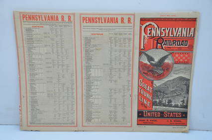
Pennsylvania Railroad July 8, 1885 Public TimetableJM Hobby Supply and Railroad Artifact Auctions4.4(126)See Sold PriceFeb 24, 2024
Pennsylvania Railroad May 29, 1904 Public TimetableJM Hobby Supply and Railroad Artifact Auctions4.4(126)See Sold PriceFeb 24, 2024
1849 Mitchell School ATLAS 24 MAPS America Holy Land France Africa Egypt AsiaSchilb Antiquarian Rare Books4.8(421)See Sold PriceMar 31, 2024
1888 Hand Book of the Pennsylvania Lines Containing Maps of Principal Cities - First EditionRail & Road Auctions4.6(165)See Sold PriceMar 07, 2024
1855 Guide for the Pennsylvania Railroad with an Extensive Map from the Pennsylvania RailroadRail & Road Auctions4.6(165)See Sold PriceMar 07, 2024
1876 The Centennial Exhibition Pennsylvania Railroad Worlds Fair Guide with Map and Trade CardRail & Road Auctions4.6(165)See Sold PriceMar 07, 2024
1904 Pennsylvania Railroad Winter Excursions Book with Fold Out MapRail & Road Auctions4.6(165)See Sold PriceMar 07, 2024
Pair of Early Railroad Maps - 1874 Delaware, Lackawanna & Western and 1876 Pennsylvania RailroadRail & Road Auctions4.6(165)See Sold PriceMar 07, 2024
Mitchell - Map of the City of Washington (Washington, DC)Trillium Antique Prints & Rare Books4.5(30)See Sold PriceFeb 24, 2024
1822 MAP of NORTH & SOUTH AMERICA GEOGRAPHICAL STATISTICAL HISTORICAL antiqueJasper524.5(9.8k)See Sold PriceFeb 27, 2024
Western Africa by Edward Weller. Early British/French settlements 1859 old mapJasper524.5(9.8k)See Sold PriceFeb 28, 2024
George F. Cram - Historical Map of Pittsburgh Allegheny PennsylvaniaProverde Auctions4.3(3)See Sold PriceFeb 28, 2024
Vintage Street Map of Pittsburgh, Pennsylvania - Rand McNallyProverde Auctions4.3(3)See Sold PriceFeb 28, 2024
Monmouth, Illinois Vintage Topography MapRapid Estate Liquidators and Auction Gallery4.5(1.1k)See Sold PriceFeb 28, 2024
Antique Pennsylvania Map Fragment incl Wellersburg and New CentervilleCordier Auctions4.4(1.5k)See Sold PriceMar 02, 2024


![[MAPS OF CHICAGO AND ILLINOIS]. A group of 4 maps and (1 of 3)](https://p1.liveauctioneers.com/197/128324/65283842_1_x.jpg?height=282&quality=70&version=1537814359)