SoldMap of North Pole & adjacent latitudes 1757Heading: Author: Bowen, Emanuel Title: A New & Accurate Map of the North Pole with all the Countries hitherto Discovered Situated near or adjacent to it as well as some others more Remote Place PubliSee Sold Price
SoldMap of North Pole & adjacent latitudes 1757Heading: (North Pole) Author: Bowen, Emanuel Title: A New & Accurate Map of the North Pole with all the Countries hitherto Discovered Situated near or adjacent to it as well as some others more RemoteSee Sold Price
NORTH POLE ARCTIC. to 45˚ N Latitude. Alaska as Russian Territory. SDUK 1846 mapTITLE OF MAP (NOT PRINTED ON THE PAGE):'WORLD ON GNOMONIC PROJECTION, V., From North Pole to 45˚ N Lat' Cotidal lines are marked on the map. The US-Canadian border is marked as running along theSee Sold Price
SoldHalley (Capt. Edmund) - A New and Correct Sea Chart ofreduced version of Halley's large 2-sheet map by Mount and Page, advertised in lower left corner, with adjacent inset of the North Pole, title cartouche upper left, engraved chart by John Harris, on 2See Sold Price
Map of the Countries Situate About the North Pole AsTitle: Map of the Countries Situate About the North Pole As Far As The 50th Degree of North Latitude. Publication Date: 1814 Cartographer: CAREY, MATHEW Publisher: M. CAREY Size: Height - 9.3Width ArcSee Sold Price
Mathew Carey 1814. Polar Map.A map of the countries situate about the North Pole as far as the 50th degree of north latitude. 10 1/2" x 11" Hand Colored.See Sold Price
SoldNORTHERN LATITUDES POLE ARCTIC British Columbia part ofTITLE OF MAP (NOT PRINTED ON THE PAGE):'WORLD ON GNOMONIC PROJECTION, V., From North Pole to 45 N Lat' The top image on the right hand side shows the entire map. To view a close up of the map showingSee Sold Price
SoldPhysical Planisphere [map] 1757Heading: (Planisphere) Author: Title: A Physical Planisphere wherein are represented all the known Lands and Seas wth. the Great Chains of Mountains wch. traverse the Globe from the North Pole. AdaptSee Sold Price
Physical Planisphere [map] 1757Title: A Physical Planisphere wherein are represented all the known Lands and Seas wth. the Great Chains of Mountains wch. traverse the Globe from the North Pole. Adapted to Monsr: Buache's Memoire ReSee Sold Price
SoldLaurie and Whittle Map of British ColoniesLAURIE, Robert (1755-1836) & WHITTLE, James (1757-1818). New and Correct Map of the British Colonies in North America with the Adjacent States of New England, Vermont, New York, Pennsylvania and New JSee Sold Price
MAP, North Pole, RhodeNorth Pole. Johann Christoph Rhode, Tabula Geographica Hemisphaerii Borealis ad Emendatiora quae Adhuc Prodierunt Exempla..., from Atlas Geographicus..., 1753 (circa). Hand Color. This interesting andSee Sold Price
MAP, North Pole, DelisleNorth Pole. Delisle/Dezauche, Hemisphere Septentrional pour voir Plus Distinctement les Terres Arctiques, 1790 (circa). Hand Color. This is a Buache/Dezauche issue of this important map, originally prSee Sold Price
SoldScherer World Map North Pole at Center c.1700Title: Repræsentatio Totius Orbis Terraquei Cuius Partes, Quæ Umbra Carent, Fide Catholica Imbutæ Sunt, Reliqæ Omnes Inumbratæ Religionis Catholicæ Expertes Sunt Author: Scherer, Henrich DescripSee Sold Price
Tirion: Antique Map of North Pole & Northern RegionsTitle/Content of Map: North Pole & Northern Regions by Tirion Date Printed: 1735-1740 Cartographer: Isaak Tirion Material/Medium: Paper Size: 13" x 13" Hand colored. Copperplate engraved. Published inSee Sold Price
SoldAntique 19th C Victorian China Japan Korea MapAntique 19th C Victorian China Japan Korea Map & North Pole Map. Printed by J Martin Miller. Measures 16.5 x 22.5 inches.See Sold Price
Antique 19th C Victorian China Japan Korea MapAntique 19th C Victorian China Japan Korea Map & North Pole Map. Printed by J Martin Miller. Measures 16.5 x 22.5 inches.See Sold Price
Mercator / Hondius: Antique Map of North Pole with GoldTitle: SEPTENTRIONALIUM Terrarum descriptio. Per Gerardum Mercatore. 1623 Mercator & Hondius North Pole heightened in gold and filled with cartographic myths Map maker: Gerard Mercator & Jocodus HondiSee Sold Price
SoldMap of North Pole "Hand Painted" COAVintage map from London 1625 of Polus Arcticus cum vicinis regionibus. Has COA included. Map is in protective plastic. Also has pages from boook. Measures 12.5" x 8 1/4". See pictures, condition is coSee Sold Price
De Wit Map of North PolePoli Arctici et Circumiacentium Terrarum. Frederick de Wit (1629/1630-1706). Engraved Map with Original Hand color. Amsterdam, c. 1676. 20 3/4 x 24 3/4 inches sheet, 32 1/2 x 36 1/4 inches framedSee Sold Price
SoldBenjamin Cole, map of North Pole, entitled "A PhysicalBenjamin Cole, map of North Pole, entitled "A Physical Planisphere wherein are represented all the known Lands and Seas with the Great Chains of Mountains w'ch traverse the Globe from the North Pole",See Sold Price
SoldDe Wit Map of North PoleDE WIT, Frederick (1629-1706) after Henricus Hondius. Poli Arctici et Circumiacentium Terrarum. Engraved map with original hand color. Amsterdam: 1636 (State 6, 1676). 21" x 24 3/4" sheet, 32 1/2" x 3See Sold Price
Ritter Map of North PoleRITTER, Francis (d.1641). Untitled World and Horological Diagrams. Copperplate engraving. Nuremberg: Lochner, 1607. 11" x 13 1/4" sheet, 23" x 24 1/2" framed. A rare and extremely unusual map shows thSee Sold Price
ASTRONOMY CELESTIAL Star map chart North Pole Polar.TITLE/CONTENT OF MAP: 'Star Map - Equatorial North Pole No.5' (P-8-010881)The top image on the right hand side shows the entire map. To view a close up of the map showing the level of printed detail,See Sold Price
1898 Rand McNally Map of North Pole Area -- North PolarTitle/Content: 1898 Rand McNally Map of North Pole Area -- North Polar Regions Cartographer: Rand McNally Year/Place: 1898, Chicago Size: 18.6 x 12.3 in. when combined Description: This is a highly deSee Sold Price
Crams Map of North Dakota-Complete Railroad System and County Map-1907JM Hobby Supply and Railroad Artifact Auctions4.4(126)See Sold PriceFeb 24, 2024
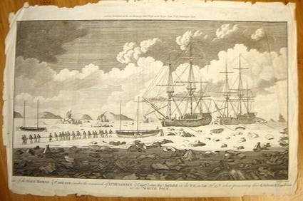
ALEXANDER HOGG ca1790 Engraving Captain Mulgrave Ships Ice Bound Cpt CookLuis Porretta Fine Arts4.3(10)See Sold PriceMar 02, 2024
Ernst Plank (Germany) Oil Lamp Magic Lantern With SlidesDana J. Tharp Auctions4.7(268)See Sold PriceFeb 24, 2024
[ARCTIC]. BOWEN, Emanuel. A New & Accurate Map of the North...Potter & Potter Auctions4.6(539)See Sold PriceMar 07, 2024
Group of 3 Santa Claus Blow Mold Christmas Yard DecorationsMatthew Bullock Auctioneers4.7(1.8k)See Sold PriceFeb 24, 2024
Map: An 18thC engraved and hand coloured map of North America and South America, titled DeClaydon Auctioneers Ltd4.3(125)See Sold PriceFeb 26, 2024
1822 MAP of NORTH & SOUTH AMERICA GEOGRAPHICAL STATISTICAL HISTORICAL antiqueJasper524.5(9.8k)See Sold PriceFeb 27, 2024
New and Correct Map of North America With the West India Islands,Jasper524.5(9.8k)See Sold PriceFeb 27, 2024
Coste Occidentale d’Afrique…' West Africa. Gulf of Guinea. BELLIN 1746 mapJasper524.5(9.8k)See Sold PriceFeb 28, 2024
Coste Orientale d’Afrique…' East Africa Kenya Tanzania Somalia. BELLIN 1746 mapJasper524.5(9.8k)See Sold PriceFeb 28, 2024
BYRD RICHARD E.: (1888-1957)International Autograph Auctions Europe S.L.4.5(52)See Sold PriceMar 14, 2024


![Physical Planisphere [map] 1757 (1 of 1)](https://p1.liveauctioneers.com/642/46204/20993568_1_x.jpg?height=282&quality=70&version=1381425533)
![Physical Planisphere [map] 1757 (1 of 1)](https://p1.liveauctioneers.com/642/34988/14371540_1_x.jpg?height=282&quality=70&version=1353355505)


![[ARCTIC]. BOWEN, Emanuel. A New & Accurate Map of the North... (1 of 1)](https://p1.liveauctioneers.com/928/318880/171360917_1_x.jpg?height=282&quality=70&version=1707501302)