The World And It's Peoples Photographed And Described 1910 Folio SizeNorth American Artifact Auctions4.6(184)See Sold PriceApr 20, 2024
Sold1838 HAND COLORED MAP MASSACHUSETTSFramed under glass. Map 14 inches x 12 inches. Overall 17 inches x 21 inches. Not examined out of frame. 1st edition 1838 by T. G. Bradford. Some foxing and stains.See Sold Price
Martha's Vineyard Map Massachusetts Tisbury EdgarMartha's Vineyard / Dukes County, Massachusetts.'' Published by B. Ashburton Tripp: Alexandria, Virginia. First edition. Map features the Island of Martha's Vineyard in center; details include towns,See Sold Price
Martha's Vineyard Map Massachusetts Tisbury Edgartown''Martha's Vineyard / Dukes County, Massachusetts.'' Published by B. Ashburton Tripp: Alexandria, Virginia. First edition. Map features the Island of Martha's Vineyard in center; details include townsSee Sold Price
SoldAntique Map : Massachusetts & Connecticut - 1883Antique Map : Massachusetts, Rhode Island & Connecticut - 1883. Hand Tinted. Size : 12" x 9.75"See Sold Price
Colton: Antique Map Massachusetts & Rhode Island, 1861Title/Content of Map: Massachusetts & Rhode Island by Colton Date Printed: 1861 Cartographer: J.H. Colton Material/Medium: Paper Size: 17 1/4" x 14" Hand colored steel engraved Map from 'Colton's GeneSee Sold Price
SoldMassachusetts, Connecticut and Rhode Island insert ofTitle/Content of Map: Massachusetts, Connecticut and Rhode Island insert of Bostn Date Printed: 1877 Cartographer: F.A. Gray Material/Medium: Paper Size: 25 1/2" x 16" Map is set in matting. May be reSee Sold Price
SoldColton: Antique Map of Massachusetts & Rhode IslandTitle/Content of Map: Massachusetts & Rhode Island by Colton Date Printed: Cartographer: J.H. Colton Size: 14" x 17" Material/Medium: Paper Provenance: New York From 'Colton's General Atlas'. Hand colSee Sold Price
SoldMassachusetts,Connecticut, and Rhode IslandTitle/Content of Map: Massachusetts,Connecticut, and Rhode Island Date: 1866 Cartographer: by Johnson Size: 18x29” Provenance: New York. Minor tear on sides and bottom. Some centerfold weakness. DoeSee Sold Price
SoldTanner: Antique Map of Massachusetts & Rhode IslandTitle/Content of Map: Massachusetts & Rhode Island with insert of Boston by Tanner Date Printed: 1843 Cartographer: H.C. Tanner Material/Medium: Paper Size: 17" x 14" Hand colored engraved Map based oSee Sold Price
SoldMassachusetts, Connecticut, Rhode IsTitle/Content of Map: Massachusetts, Connecticut, Rhode Is Date: 1863 Cartographer: By Johnson & Ward. From, Johnson’s New Illustrated Family Atlas Size: 18x26 1/2” Provenance: New York Hand colorSee Sold Price
Dorr: Antique Map of Massachusetts & Rhode Island, 1850Map: Massachusetts & Rhode Island Publication Date: 1850 Cartographer: ENOS DORR & CO. Publisher: ENOS DORR & CO. Size: Pocket – 7.30 H x 11.80 W Inches Map showing MA, RI & CT detailing counties, tSee Sold Price
Sold1833 Map1833 Map "MASSACHUSETTS / CONNECTICUT / RHODE ISLAND….Published H.P. Sumner & Co. Hartford Ct. / 1833". Sight 15" x 20", overall 22 1/2" x 27".See Sold Price
Massachusetts Conn. Rhode Island 1886Title/Content of Map: Massachusetts Conn. Rhode Island 1886 Date Printed: 1886 Material/Medium: paper Size: approx. 21.5x13.5 inches Additional Info: The People's Unrivaled Family Atlas of the World.See Sold Price
Massachusetts Connecticut Rhode Island 1886Title/Content of Map: Massachusetts Connecticut Rhode Island 1886 Date Printed: 1886 Material/Medium: paper Size: approx. 19x13 inches Additional Info: The People's Unrivaled Family Atlas of the WorldSee Sold Price
Massachusetts and Rhode IslandTitle/Content of Map: Massachusetts and Rhode Island Date: 1842 Cartographer: MORSE & BREESE Publisher: MORSE & BREESE Size: 12Height - 14.8Width Map showing counties, towns, townships, railroads, canSee Sold Price
Massachusetts 1898Title/Content of Map: Massachusetts 1898 Date Printed: 1898 Material/Medium: Paper Size: approx 11x14 inches Additional Info: Rand McNally & Co. Reserve: $30.00 Shipping: Domestic: Flat-rate of $15.00See Sold Price
Massachusetts Conn. Rhode Island 1886Title/Content of Map: Massachusetts Conn. Rhode Island 1886 Date Printed: 1886 Material/Medium: paper Size: approx. 21.5x13.5 inches Additional Info: The People's Unrivaled Family Atlas of the World.See Sold Price
Massachusetts, Connecticut, Rhode IsTitle/Content of Map: Massachusetts, Connecticut, Rhode Is Date: 1863 Cartographer: By Johnson & Ward. From, Johnson’s New Illustrated Family Atlas Size: 18x26 1/2” Provenance: New York AdditionalSee Sold Price
Antique Map of Massachusetts & Rhode Island, 1843Title/Content of Map: Massachusetts & Rhode Island with insert of Boston Date Printed: 1843 Cartographer: based on the work of H.C. Tanner Material/Medium: Paper Size: 17" x 14" Hand colored engravedSee Sold Price
Massachusetts Conn. Rhode Island 1886Title/Content of Map: Massachusetts Conn. Rhode Island 1886 Date Printed: 1886 Material/Medium: paper Size: approx. 21.5x13.5 inches Additional Info: The People's Unrivaled Family Atlas of the World.See Sold Price
Mitchell: Antique Map of Massachusetts Conneticut, 1869Title/Content of Map: Massachusetts, Conneticut & Rhode Island by Mitchell Date Printed: 1869 Cartographer: Augustus S. Mitchell Material/Medium: Paper Size: 12" x 15" Hand colored engraved Map. FromSee Sold Price
Sold4 Maps: Bradford (1838): Mass., CT, NJ, Boston.[United States/Northeast] 4 Maps. ++ MASSACHUSETTS. ++ BOSTON. ++ CONNECTICUT. ++ NEW JERSEY. ++ Maps 10, 11, 13, and 16 from T. G. Bradford, “An Illustrated Atlas, Geographical, Statistical, And HiSee Sold Price
Sold1878 HUGE MAP of Massachusetts & Boston Harbor Rand McNally Plymouth1878 HUGE MAP of Massachusetts & Boston Harbor Rand McNally Plymouth Rand McNally was a notable 19th and early 20th-century American publishing company known for their maps and travel atlases. This enSee Sold Price
SoldANTIQUE ENGRAVED MAP OF MASSACHUSETTSc.1840 engraved map of Massachusetts and Cape Cod. Apparently unmarked/unsigned. Dimensions: (Frame) H 12.75" x W 14" (Sight) H 6.25" x 7.5" Condition: Wavy within frame, light soiling to paper.See Sold Price
18TH C. ANTIQUE MAP: FRENCH & INDIAN WAR, FRAMEDThomaston Place Auction Galleries4.4(389)See Sold PriceFeb 24, 2024
CHARLES HENRY GIFFORD (Massachusetts, 1839-1904), Luminist view of three sailboats in a quietEldred's4.7(418)See Sold PriceFeb 28, 2024
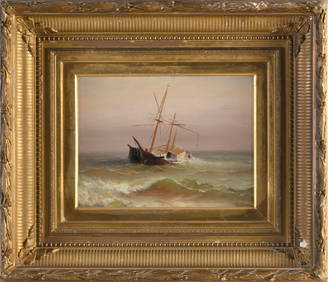
CHARLES HENRY GIFFORD (Massachusetts, 1839-1904), Shipwreck., Oil on canvas, 9.5" x 12". Framed 19"Eldred's4.7(418)See Sold PriceFeb 27, 2024
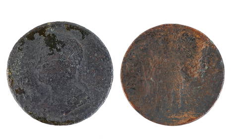
1786 VERMONT PENNY and MASSACHUSETTS COPPER CENTJohn McInnis Auctioneers,LLC4.6(504)See Sold PriceFeb 24, 2024
Large lot of assorted prints. 18th-20th century. To include: North American and other maps, CivilTremont Auctions4.6(294)See Sold PriceFeb 25, 2024
1853 Colton's Railroad & Township Map of Massachusetts, Rhode Island, and ConnecticutRail & Road Auctions4.6(165)See Sold PriceMar 07, 2024
Keith Haring - Ink on New York Map, Best Buddies, Inscribed, Signed, and DatedSapphire Auction Gallery4.1(67)See Sold PriceMar 02, 2024
Rand McNally Railroad Map Cabinet w/ 21 Railroad MapsRail & Road Auctions4.6(165)See Sold PriceMar 08, 2024
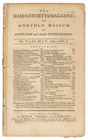
1849 THE NEW-ENGLAND MERCANTILE UNIONNorth American Artifact Auctions4.6(184)See Sold PriceApr 20, 2024
Putnam - First Map of the State of Ohio by Rufus PutnamTrillium Antique Prints & Rare Books4.5(30)See Sold PriceFeb 24, 2024
PAULINE LENNARDS PALMER (Illinois/Norway, 1867-1938), Village scene, Provincetown, Massachusetts.,Eldred's4.7(418)See Sold PriceMar 13, 2024