SoldMap of Maryland 1781Title: A Map of Maryland with Part of Virginia and Pensylvania Author: Scots Magazine Description: Copper-engraved map. 16.5x16.5 cm. (6½x6½").Key soon-to-be-former colonies at the end of the AmericSee Sold Price
Sold4 Maps incl: MAPPE-MONDE EN DEUX HEMISPHERES...[World/Maryland/Virginia] 4 Maps. ++ MAPPE-MONDE EN DEUX HEMISPHERES, L’ORIENTAL ET L’;OCCIDENTAL. [Paris]: Bonne, 1781. Recognizable as Alaska, with large inlet of water at south-center. Shows thSee Sold Price
Sold2 Maps: Maryland + A Correct Map of Virginia.[United States/Virginia/Maryland]. 2 Maps. ++ Maryland. 11 ¼” x 16 ¾”. ++ A Correct Map Of Virginia. 12 7/8” x 19 1/8”. ++ From an edition of “Carey’s General Atlas,” [ca. 1814]. PhillSee Sold Price
Sold[Rome Map ]1781, Giuseppe Vasi (Italian, 1710-178[Rome Map], Giuseppe Vasi (Italian, 1710-1782), "Nuova Pianta di Roma in Prospettira Dedicata...", 1781, engraved, folding, segmented map, on course linen, the papier-mâché slipcase mounted with larSee Sold Price
SoldFRAMED RAILROAD MAP MARYLAND, DELAWARE & DC, 1877"New Railroad Map of the States of Maryland, Delaware, and the District of Columbia", 1877; copyright 1876 G. W. Gray & Son; hand colored map features a list of railroads and their length ; central crSee Sold Price
Sold[Map, Maryland] Washington & Potomac RRtopographical "Map Showing the Washington & Potomac Railway and Branches," circa 1890; framedSee Sold Price
SoldAmos Doolittle Engraved Map: Maryland + DelawareHistoric Maps Amos Doolittle Engraved "Map of the States of Maryland and Delaware" by a.k.a. "The Paul Revere of Connecticut" c. 1796 Federal Period, Engraved by Amos Doolittle, Sculp. "Map of the StaSee Sold Price
SoldAmos Doolittle Engraved Map: Maryland + DelawareHistoric Maps Amos Doolittle Engraved "Map of the States of Maryland and Delaware" by a.k.a. "The Paul Revere of Connecticut" c. 1796 Federal Period, Engraved by Amos Doolittle, Sculp. "Map of the StaSee Sold Price
MAP, Maryland, Potomac River, BruceRare Early Map of the Upper Potomac River. Maryland, Potomac River. Norman Bruce, Sketch of the Country Between the Waters of Potomack and Those of Youghagany and Monongahela as Sketched by Genl. WashSee Sold Price
SoldAmos Doolittle Engraved Map: Maryland + DelawareHistoric Maps Amos Doolittle Engraved "Map of the States of Maryland and Delaware" by a.k.a. "The Paul Revere of Connecticut" c. 1796 Federal Period, Engraved by Amos Doolittle, Sculp. "Map of the StaSee Sold Price
1957 HISTORICAL MAP MARYLAND EASTERN SHORE & MORE3 Identical. Measures 17" x 22". Drawn by Edwin Tunis for the 60th Anniversary of the Tilghman Packing Co./1950 Talbot County Wall Map (un-mounted). 1968 & 1981 Talbot County Tourist's Guide. 1959 AAASee Sold Price
Soil Map. Maryland Worcester County SheetTitle: Soil Map. Maryland Worcester County Sheet Publication Date: 1903 Cartographer: BONSTEEL, F. E./WILLIAM T. CARTER, JR. Publisher: U.S. DEPARTMENT OF AGRICULTURE. (BUREAU OF SOILS) Brief DescriptSee Sold Price
Amos Doolittle Engraved Map: Maryland + DelawareHistoric Maps Amos Doolittle Engraved "Map of the States of Maryland and Delaware" by a.k.a. "The Paul Revere of Connecticut" c. 1796 Federal Period, Engraved by Amos Doolittle, Sculp. "Map of the StaSee Sold Price
Soil Map Maryland Harford Co. SheetTitle: Soil Map Maryland Harford Co. Sheet Cartographer: SMITH, W.G./J.O. MARTIN Publisher: U.S. DEPT. OF AGRICULTURE. BUREAU OF SOILS Size: 29 X 27 Handsomely chromolithographed map. Color coded by sSee Sold Price
Soil Map. Maryland Worcester County SheetTitle: Soil Map. Maryland Worcester County Sheet Cartographer: BONSTEEL, F. E./WILLIAM T. CARTER, JR. Publisher: U.S. DEPARTMENT OF AGRICULTURE. (BUREAU OF SOILS) Size: 33.5 X 31 Color coded demographSee Sold Price
Soil Map Maryland Harford Co. SheetTitle/Content of Map: Soil Map Maryland Harford Co. Sheet Cartographer: SMITH, W.G./J.O. MARTIN Date: 1901 Publisher: U.S. DEPT. OF AGRICULTURE. BUREAU OF SOILS Size: 29Height - 27Width Handsomely chrSee Sold Price
Sold8 Maps: Maryland + hemispheres + 6 of Florida.[Maryland/Florida/Hemispheres]. 8 Maps. Largest: 13 7/8” x 10 5/8”. Smallest: 8 1/8” x 10 3/8”. ++ The World. Hemisphere maps. [From “A New Universal Atlas, Containing Distinct Maps of all tSee Sold Price
Sold3 Framed maps: Maryland, Sandwich Isles & London.[Various] (1) “Chart of the Sandwich Isles.” London, extracting from Anderson’s edition of Cook’s Third Voyage. c.1785. 13 7/8" x 8 3/4". Framed: 19 1/2" x 14 1/2". (2) â€See Sold Price
Sold(2) 1850 COLORED MAPS: MARYLAND /DE & NEW JERSEYBoth maps removed from the same atlas, both labeled: "Entered according to an act of Congress in the year 1850 by Thomas Cowperthwait & Co. in the clerks office of the District court of the Eastern DiSee Sold Price
SoldTwo Framed 18th c. Maps Maryland - DelawareTWO framed 18th century maps of Maryland & Delaware 1) Maryland and Delaware together: "J. Denison" c. 1796 at 8" high by 10" wide inside matting.2) "State of Maryland by Samuel Lewis" measuring 11.5"See Sold Price
Sold3 Framed Maps- Maryland, Baltimore & MA/RI3 Framed Maps- Maryland, Baltimore & MA/RISee Sold Price
SoldCary: Map of Bay of Gibratar & Guadaloupe, 1781Map: 1781 Cary Map of Bay of Gibratar and Guadaloupe -- Plan of the General Attack upon the Island of Guadaloupe January 23d. 1759 [on sheet with] The Bay of Gibraltar Surveyed by Michelot & Bremond CSee Sold Price
SoldMaryland & DelawareTitle/Content of Map: Maryland & Delaware Date: 1863 Cartographer: By Johnson & Ward. From, Johnson’s New Illustrated Family Atlas Size: 18 x 13 1/2” Provenance: New York. Additional Info: Hand coSee Sold Price
SoldBicycle Ephemera LotEphemera lot: very rare c 1888 Victor Hts catalog "Victor Sunlights" 3 1/2" x 4 3/4", pocket map (Maryland and Delaware c 1880's), "1887 Bicycle Tactics" 3rd edition. All VG to exc. cond.See Sold Price
Central Railroad of New Jersey Map of Sandy Hook Route-ca. 1903JM Hobby Supply and Railroad Artifact Auctions4.4(126)See Sold PriceFeb 24, 2024
Rand McNally/Santa Fe Railroad Map of Iowa-1912JM Hobby Supply and Railroad Artifact Auctions4.4(126)See Sold PriceFeb 24, 2024
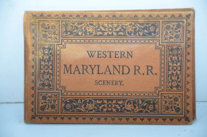
Western Maryland RR Scenery Book-1884JM Hobby Supply and Railroad Artifact Auctions4.4(126)See Sold PriceFeb 24, 2024
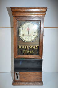
Western Maryland RR Jennings, MD Water Station ClockJM Hobby Supply and Railroad Artifact Auctions4.4(126)See Sold PriceFeb 24, 2024
LATE 17TH C. FRENCH MAP OF THE NEW WORLD BY ALEXIS-HUBERT JAILLOT (1632-1712)Thomaston Place Auction Galleries4.4(389)See Sold PriceFeb 24, 2024
18TH C. ANTIQUE MAP: FRENCH & INDIAN WAR, FRAMEDThomaston Place Auction Galleries4.4(389)See Sold PriceFeb 24, 2024
NICOLAES VISSCHER (NETHERLANDS, 1618-1709) MAP OF THE NEW WORLDThomaston Place Auction Galleries4.4(389)See Sold PriceFeb 24, 2024
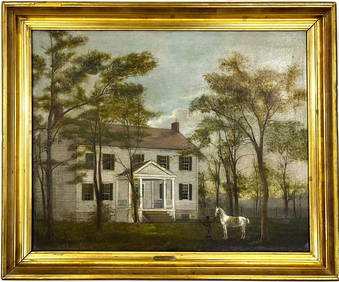
Early American Montgomery County Maryland Oil Painting on Canvas Gilt FramedChina Luban Art & Antique, Inc.4.4(78)See Sold PriceFeb 24, 2024
Keith Haring - Ink on New York Map, Best Buddies, Inscribed, Signed, and DatedSapphire Auction Gallery4.1(67)See Sold PriceMar 02, 2024
Rand McNally Railroad Map Cabinet w/ 21 Railroad MapsRail & Road Auctions4.6(165)See Sold PriceMar 08, 2024
D'Oyly (Calcutta, India) - Government House from St. Andrew's LibraryTrillium Antique Prints & Rare Books4.5(30)See Sold PriceFeb 24, 2024
D'Oyly (Calcutta, India) - Procession of the CurruckpoojaTrillium Antique Prints & Rare Books4.5(30)See Sold PriceFeb 24, 2024
Putnam - First Map of the State of Ohio by Rufus PutnamTrillium Antique Prints & Rare Books4.5(30)See Sold PriceFeb 24, 2024
Carey, pub. 1796 - Map of the State of MarylandTrillium Antique Prints & Rare Books4.5(30)See Sold PriceFeb 24, 2024
First 50 plates from Audubon's Quad Quarto (all in Vol. I)PBA Galleries4.7(383)See Sold PriceMar 07, 2024


![[Rome Map ]1781, Giuseppe Vasi (Italian, 1710-178 (1 of 2)](https://p1.liveauctioneers.com/268/28159/10763989_1_x.jpg?height=282&quality=70&version=1327357154)

![[Map, Maryland] Washington & Potomac RR (1 of 4)](https://p1.liveauctioneers.com/523/48656/22613874_1_x.jpg?height=282&quality=70&version=1386104939)