Sold[MAP OF INDIA]. Stanford's Portable Map Of India[MAP OF INDIA]. Stanford's Portable Map Of India: Shewing its present Divisions and the adjacent parts of Beluchistan, Afghanistan, Turkestan, Burmah and Siam. Lon: Edward Stanford, (1880). 33 3/4 x 2See Sold Price
SoldIndia.- Stanford (Edward) Stanford's Map of India,India.- Stanford (Edward) Stanford's Map of India, in two sections, North and South, with large title encircled in upper right corner of North section, the South section with three diagrams illustratiSee Sold Price
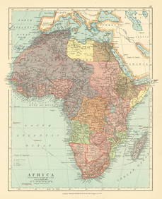
SoldStanford’s Map of India... 1857. Folding map.[India] Edward Stanford. Stanford’s Map of India Based on Surveys Executed by Order of the Honourable the East India Company, Special Maps of the Surveyor General and Other Authorities; Showing theSee Sold Price
SoldStanford (Edward) Stanford's Map of IndiaStanford (Edward) Stanford's Map of India,2 hand-coloured lithographed maps of India, in sections, linen-backed, cloth slipcase, original printed paper label, with ink signature of Lord FarnhaSee Sold Price
Indien: Stanford's Map of IndiaIndien. Stanford's Map of India based on the surveys executed by order of the honourable the East India Company ... showing the latest territorial acquisitions of the British Empire and the IndepeSee Sold Price
SoldStanford (Edward) Map of IndiaStanford (Edward) Map of India,hand-coloured engraved map in 2 parts, dissected and linen-backed, each part 825 x 1270mm., original cloth slip-case with paper label to upper cover (chipped), 8See Sold Price
India North Western Frontier Kashmir Pamir region Afghanistan. STANFORD 1896 mapCAPTION PRINTED BELOW PICTURE: 'Map of the North Western Frontier of India showing the Pamir region and part of Afghanistan' DATE PRINTED: 1896 IMAGE SIZE: Approx 48.5 x 67.5cm, 19 x 26.5 inches (LargSee Sold Price
India North Western Frontier Kashmir Pamir region Afghanistan. STANFORD 1894 mapCAPTION PRINTED BELOW PICTURE: 'Map of the North Western Frontier of India showing the Pamir region and part of Afghanistan' DATE PRINTED: 1894 IMAGE SIZE: Approx 48.5 x 67.5cm, 19 x 26.5 inches (LargSee Sold Price
West India Islands & Central American States. Caribbean. STANFORD 1904 old mapCAPTION PRINTED BELOW PICTURE: 'The West India Islands and Central American States' DATE PRINTED: 1904 IMAGE SIZE: Approx 52.5 x 70.5cm, 20.5 x 27.75 inches (Large); Please note that this is a foldingSee Sold Price
India North Western Frontier Kashmir Pamir region Afghanistan. STANFORD 1896 mapTITLE/CONTENT OF MAP: 'Map of the North Western Frontier of India showing the Pamir region and part of Afghanistan' DATE PRINTED: 1896 IMAGE SIZE: Approx 50.5 x 68.5cm, 20 x 27 inches (Large); PleaseSee Sold Price
Stanford Map of IndiaSTANFORD, Edward (1827-1904). India. Lithograph with original hand color from the Society for the Diffusion of Useful Knowledge. London: Edward Stanford, 1857-1870. 17 1/4" x 13 3/4" sheet.See Sold Price
SoldRand McNally Map India, Burma, Nepal and Ceylon, 1898Map: 1898 Rand McNally India, Burma, Nepal and Ceylon -- India Cartographer: Rand McNally Year / Place: 1898, Chicago Map Dimension: 26.2 X 19.2 in. A very nice map of South East Asia. Highly detailedSee Sold Price
SoldAntique Map : India - 1802Antique Map : India - 1802 from Walker's Geography & Gazette. Size : 10.25" x 8"See Sold Price
SoldHAND COLORED ENGRAVED MAP, INDIA, MONFIEUER SANFONHAND COLORED ENGRAVED MAP, "INDIA" MONFIEUER SANFON 17TH CENTURY. SHEET 15 1/2 X 13 5/8"See Sold Price
MAP, India & Sri Lanka, RuscelliIndia & Sri Lanka. Ptolemy/Ruscelli, Tabula Asiae X, 1598 (published). Black & White. This uncommon Ptolemaic map on a trapezoidal projection is centered on India with recognizable river systems, butSee Sold Price
MAP, India & Sri Lanka, Ptolemy/RuscelliIndia & Sri Lanka. Ptolemy/Ruscelli, Tabula Asiae X, from La Geografia di Claudio Tolomeo Alessandrino…, 1561 (published). Black & White. This Ptolemaic map on a trapezoidal projection is centered oSee Sold Price
SoldMap India by J. Arrowsmith, published 15 Feb. 1832Map India by J. Arrowsmith, published 15 Feb. 1832See Sold Price
MAP, India, SansonIndia. Nicolas Sanson, Prequ' Isle de l'Inde deca la Gange, ou sont les Royaumes, de Decan, de Golconde de Bisnagar, et le Malabar, from Geographise en Historise Werelt Beschryving, 1699 (published).See Sold Price
Big Map India and Southeast Asia coloured LapieMap of India and Southeast Asia, big size, coloured by hand. Author: Lapie M. (Pierre) (1779-1850) Atlas: Atlas universel de geographie ancienne et moderne Date: 1829 Technique: etching on steel LeafSee Sold Price
SoldLot of Maps India Sri LankaGroup of seven maps of India and Sri Lanka (Ceylon), including two maps by Guillaume Delisle (1675-1726); two copies of "Nouvelle Carte de L'Isle de Ceylon, avec des Remarques Historiques." one hand cSee Sold Price
SoldOver 38 Maps: India, Washington, NGS, Travel...[Washingt[Washington/Travel/NGS/India]. Over 38 Maps. Size varies. ++ ENOSBURGH FALLS: Town of Enosburgh. [Village in Vermont. Probably from an atlas published by Beers, 1871.] Image side near fine, vSee Sold Price
SoldBartholomew, John 1922 Lot of 3 LG Maps. India & AsiaIncl India/Farther India, Asia Political, and South Western Asia. Large Lithograph Maps Published 1922 by The Times, London for "The Times Survey Atlas of the World" Maps by John George Bartholomew ofSee Sold Price
SoldBartholomew, John 1922 Lot of 5 Maps. IndiaIncl India & Farther India, India North West, India North East, India South, and The Ganges Valley. Large Lithograph Maps Published 1922 by The Times, London for "The Times Survey Atlas of the World"See Sold Price
SoldAntique Map of India into Southeast Asia, 1541Map: India into Southeast Asia Date Printed: 1541 Cartographer: Waldseemuller & Friers Material/Medium: Paper Size: 21" X 14 1/4" Condition: Excellent Second oldest Map of India into Malay peninsula.See Sold Price
Duval - Pair: Map of India & Map of MaldivesTrillium Antique Prints & Rare Books4.5(32)See Sold PriceFeb 24, 2024
INDIA WITHIN THE GANGES SUSAN GOLE ILLUSTRATED MAPS EARLY CARTOGRAPHYJasper524.5(9.9k)See Sold PriceFeb 27, 2024
New and Correct Map of North America With the West India Islands,Jasper524.5(9.9k)See Sold PriceFeb 27, 2024
1834 Malte-Brun Map of the Caribbean -- West India IslandsJasper524.5(9.9k)See Sold PriceFeb 27, 2024
Africa. Congo Free Trade Area. British South Africa Company. STANFORD 1896 mapJasper524.5(9.9k)See Sold PriceFeb 28, 2024
Northwest Africa. Morocco Sahara Rio do Oro Ain Sefra Gardaia. STANFORD 1904 mapJasper524.5(9.9k)See Sold PriceFeb 28, 2024
Central Africa. Congo Free State Rhodesia German East Africa. STANFORD 1896 mapJasper524.5(9.9k)See Sold PriceFeb 28, 2024
Africa. French West/Equatorial. Tanganyika Belgian Congo. STANFORD c1925 mapJasper524.5(9.9k)See Sold PriceFeb 28, 2024
Africa. Congo Free Trade Area. British South Africa Company. STANFORD 1894 mapJasper524.5(9.9k)See Sold PriceFeb 28, 2024
Afrique…Nord-Ouest' & 'Inde' by Meissas. N Africa India Singapore 1861 old mapJasper524.5(9.9k)See Sold PriceFeb 28, 2024
Northwest Africa. Morocco Sahara Rio do Oro Ain Sefra Gardaia. STANFORD 1904 mapJasper524.5(9.9k)See Sold PriceFeb 28, 2024
Blackie (Pub) 1882 Folio Map. West India Islands & Central AmericaAlbion Auctions4.6(341)See Sold PriceMar 01, 2024
Stanford, Edward 1901 Large Map. Geological Map of the British IslesAlbion Auctions4.6(341)See Sold PriceMar 01, 2024
1792 OLD INDIA HISTORY ANTIQUE ILLUSTRATED WITH MAPS OF THE EIGHTEENTH CENTURY IN FRENCHNY Elizabeth 4.2(86)See Sold PriceMar 03, 2024
![[MAP OF INDIA]. Stanford's Portable Map Of India First Image](https://p1.liveauctioneers.com/dist/images/placeholder.jpg?height=282&quality=95&width=282)
![[MAP OF INDIA]. Stanford's Portable Map Of India (1 of 0)](https://p1.liveauctioneers.com/dist/images/placeholder.jpg?height=282&quality=70)
![[MAP OF INDIA]. Stanford's Portable Map Of India First Image](https://p1.liveauctioneers.com/dist/images/placeholder.jpg?height=282&quality=1&width=282)