SoldEarly Map of America, Eastern United States, M. SeutterTitled "Novi Belgii in America Septentrionali" with very elaborate cartouche and with vignette view of New Amsterdam (New York). Exquisite color, well preserved, laid down. Size: 19 7/8" x 22 3/4" (siSee Sold Price
Sold1799 United States of America Antique Map1799 United States of America Antique Map. Interesing early map of U.S. with all beyond the Mississippi River labelled Louisiana. Sized: 14" H x 19 1/2" WSee Sold Price
SoldGrp: Early Maps of US CitiesGroup of maps, primarily early maps of US and other American cities, including Colonial and Revolutionary period maps of New York City. Includes "The United States of America, according to the TreatySee Sold Price
SoldJOHN MELISH (SCOTLAND/AMERICAN 1771-1822), EARLY ANDJOHN MELISH (SCOTLAND/AMERICAN 1771-1822), EARLY AND RARE MAP OF THE UNITED STATES OF AMERICA, C.1813. ENTERED AS THE ACT DIRECTS AND PUBLISHED BY JOHN MELISH, PHILADELPHIA, JUNE 1813. SIGHT 13 X 17 1See Sold Price
SoldTwo Early English Maps of the United States,Two Early English Maps of the United States, GUTHRIE, William. – DARTON, William. A Map of the United States of America, Agreeable to the Peace of 1783. and GIBSON, John. The British Governments inSee Sold Price
SoldEARLY MAP OF THE UNITED STATES BY FADEN.EARLY MAP OF THE UNITED STATES BY FADEN. Handcolored engraving, titled The United States of North America with the British Territories and Those of Spain. London: William Faden, 1796. Discoloration. 2See Sold Price
SoldEarly United States Map.Map titled "Map of the United States of America. J. Melish del. Designed to illustrate the Geological Memoir of Wm. Maclure Esqr.". Map measures 13.75" x 17.5" (sight) and exhibits some toning, previoSee Sold Price
SoldTwo early maps, GA & US and obsolete currencyLot of two early maps, Georgia and United States along with obsolete currency. 1st item - Early map of Georgia titled, "North America. Sheet XII, Georgia, with Parts of North and South Carolina, TenneSee Sold Price
SoldEARLY WALL MAP BY MONKEARLY WALL MAP BY MONK. "New Map of that Portion of North America, Exhibiting the United States and Territories, the Canadas, New Brunswick, Nova Scotia, and Mexico, also Central America and the WestSee Sold Price
Large Early American Railroad Map Of United StatesA large early American railroad map of north east and central America. Hand colored and highlighted trails around the United States spanning from Wisconsin, Missouri, North Carolina, Maine and parts oSee Sold Price
SoldGroup of Early MapsGroup of Early Maps. Americae Nova description Impensis Anae Seile, 1663(14" x 16 1/2"); William C. Woodbridge United States Map, 1821 (12 1/2" x 19 1/2"); A New Map of America, 1799, by Mr. WauthierSee Sold Price
SoldEarly 19th Century hand colored engraved pocket mapEarly 19th Century hand colored engraved pocket map United States of America Corrected and Improved from the Best Authorities, issued by Benjamin Warner, Philadelphia, 1820. Engraved by Hugh Anderson.See Sold Price
SoldEarly McLaughlin Bros. Horseless Carriage Game.Game includes an original box, the complete cover has all side aprons, one or two small tears on lid and instructions on the back of lid. Board shows a map of North America: United States, Canada andSee Sold Price
Ettling: Antique Map of Civil War USA, 1863Title/Content of Map: 'United States of North America (Eastern & central)' The map depicts the United States as divided in the early part of the Civil War between the Union states, the Confederate staSee Sold Price
Sold1857 MONK'S NEW AMERICAN MAP OF NORTH AMERICA, UNITED1857 MONK'S NEW AMERICAN MAP OF NORTH AMERICA, UNITED STATES AND TERRITORIES AND MORE AS PICTURED. MEASURES 60" X 66". HAS SOME TEARS, STAINS, AND CRINKLING USUALLY FOUND WITH THESE ROLL DOWN EARLY MASee Sold Price
SoldCIVIL WAR USA showing Union Confederate & BorderTITLE/CONTENT OF MAP: 'United States of North America (Eastern & central)' The map depicts the United States as divided in the early part of the Civil War between the Union states, the Confederate staSee Sold Price
CIVIL WAR USA showing Union Confederate & BorderTITLE/CONTENT OF MAP: 'United States of North America (Eastern & central)' The map depicts the United States as divided in the early part of the Civil War between the Union states, the Confederate staSee Sold Price
Sold1855 Plymouth Pilgrims Memorial Colonial Americana1855 Plymouth Pilgrims Memorial Colonial Americana Mayflower Indians War MAP William Russell’s account of early Colonial America is an important look into United States history. “Pilgrim MemorialsSee Sold Price
SoldAntique map, "United States of America", by JohnAntique map, "United States of America", by John Melish, 1818, Compiled from the latest and best authorities, 16.25" by 19.5". Notice: Please note that our auctions will continue in the online only foSee Sold Price
SoldGuthrie, William 1798 Map. United States of America"The United States of America according to the Treaty of Peace of 1784" Copper Engraved Map Published 1798, London for "A New Geographical, Historical and Commercial Grammar..." by William Guthrie. ThSee Sold Price
Sold18thc Map: United States of America, Wilkes, 1797Framed antique map, United States of America, Published London 1797 by J. Wilkes. Engraved by Neele, 352 Strand, London. Hand colored, the map shows the United States in the Decade after the AmericanSee Sold Price
SoldA MAP, UNITED STATES OF AMERICA, J. CALVIN SMITH, NEW YA MAP, UNITED STATES OF AMERICA, J. CALVIN SMITH, NEW YORK, SHERMAN & SMITH, 1846, for travelers showing the railroad, canals and stage roads with distances. 22" x 26". Framed. NOTE: scale ca. 1:4, 25See Sold Price
SoldAN ANTIQUE MAP, "United States of America," NEW YORK,AN ANTIQUE MAP, "United States of America," NEW YORK, 1827, hand colored engraving on paper, engraved by Benjamin Tanner (1775-1848). 17" X 21 5/8" Note: This map unusually shows two locations for GalSee Sold Price
SoldA MAP "UNITED STATES NORTH AMERICA", G. H. SWANSTON,A MAP "UNITED STATES NORTH AMERICA", G. H. SWANSTON, 1849, Uncommon map with interesting western territories. Dakotah [sic] incorporates the territory between Minnesota and the Missouri River. The larSee Sold Price
Early Jens Risom Model 108 Arm Chair for Risom Designs in Walnut and Original Naugahyde c. 1950sBidhaus4.3(757)See Sold PriceFeb 25, 2024
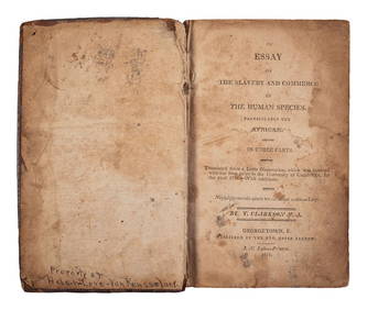
CLARKSON, Thomas (1760-1846). An Essay on the Slavery and Commerce of the Human Species,Freeman's | Hindman4.4(1.6k)See Sold PriceFeb 27, 2024
Arrowsmith & Lewis - Map of the United StatesTrillium Antique Prints & Rare Books4.5(30)See Sold PriceFeb 24, 2024
Carey, pub. 1796 - A Chart of the West IndiesTrillium Antique Prints & Rare Books4.5(30)See Sold PriceFeb 24, 2024
Carey, pub. 1796 - Map of the State of MarylandTrillium Antique Prints & Rare Books4.5(30)See Sold PriceFeb 24, 2024
Carey, pub. 1796 - Map of GeorgiaTrillium Antique Prints & Rare Books4.5(30)See Sold PriceFeb 24, 2024
Carey, pub. 1796 - Map of The State of South CarolinaTrillium Antique Prints & Rare Books4.5(30)See Sold PriceFeb 24, 2024
Carey, pub. 1796 - Map of KentuckyTrillium Antique Prints & Rare Books4.5(30)See Sold PriceFeb 24, 2024
Carey, pub. 1796 - Map of the Tennassee State formerly part of North Carolina (Tennessee)Trillium Antique Prints & Rare Books4.5(30)See Sold PriceFeb 24, 2024
Early Blonde American of Martinsville High Back Lounge Chair in Original Seafoam Blue Fabric c.Bidhaus4.3(757)See Sold PriceMar 01, 2024
Cooke, George 1801 Antique Map. United States of AmericaAlbion Auctions4.6(341)See Sold PriceMar 01, 2024
Blackie (Pub) 1882 Folio Map. United States of North AmericaAlbion Auctions4.6(341)See Sold PriceMar 01, 2024
Map of United States of North America, 1785Antiques Online Auctions4.6(410)See Sold PriceMar 14, 2024