SoldMoll: Antique Map of Colonial America New FranceTitle/Content of Map: Colonial America New France by Moll Date Printed: 1746 Cartographer: Thomas Salmom & Herman Moll Material/Medium: Paper Size: 14 1/2" x 9 1/2" Copperplate engraved. Published inSee Sold Price
SoldLotter map of Colonial America, 1776,[Carte Nouvelle de l'Amerique Angloise] by Mathias Albrecht Lotter, Augsburg, 1776, double-page copper engraving, hand colored, 24 x 19-1/2 in. (sight), in modern frame. Dampstains at bottom, top margSee Sold Price
SoldMap of Colonial America[Carte Nouvelle de L'Amerique Angloise…] by Matthieu Albert Lotter, Augsburg, circa 1776, from Lotter's [Atlas Geographique,] showing the Atlantic seaboard from Canada to Florida with the 13 originaSee Sold Price
Jansson Map of Colonial AmericaJANSSON, Jan (1588-1664). Nova Belgica et Anglia Nova. Engraved map with original hand color. Amsterdam, 1649. 19 5/8" x 23" sheet. A second state. Derived from De Laet's map of 1630, which was importSee Sold Price
MAP - Colonial North America. ConderColonial Eastern North America & West Indies. Thomas Conder, Various Plans and Draughts of Cities, Towns, Harbours &c. Drawn from the Latest Authorities, 1780 (circa). Hand Color. This very attractiveSee Sold Price
SoldBellin: Antique Map of Northeastern Colonial AmericaTitle/Content of Map: Northeastern Colonial America by Bellin Date Printed: 1740-70's Cartographer: J.N. Bellin& J.F. La Harpe Size: 13" x 10" Material/Medium: Paper Provenance: New York Copperplate eSee Sold Price
SoldGeorge Washington Liverpool Creamware PitcherGlass and PorcelainHistoric George Washington Liverpool Creamware Pitcher With Benjamin Franklin and a Map of Colonial America c.1790, Historical Liverpool Creamware Pitcher, George Washington and a MSee Sold Price
SoldGeorge Washington Liverpool Creamware PitcherGlass and PorcelainHistoric George Washington Liverpool Creamware Pitcher With Benjamin Franklin and a Map of Colonial America c.1790, Historical Liverpool Creamware Pitcher, George Washington and a MSee Sold Price
Sold5 books on mapping of eastern US, 17th-18th C.[Reference]. 5 books pertaining to eastern United States. Vp:vp. 8vo/4to. First cloth in dj, rest in wraps. Mostly very good. ++ William Cumming. British Maps Of Colonial America. (1974). ++ English MSee Sold Price
de l'Isle: Antique Map of Colonial North America, 1745Carte du Mexique et de la Floride'. Colonial North America. This early map of North America shows it divided into colonies of Spain (red), France (blue) and Great Britain (yellow), with the then BritiSee Sold Price
de l'Isle: Antique Map of Colonial North America, 1745Carte du Mexique et de la Floride'. Colonial North America. This early map of North America shows it divided into colonies of Spain (red), France (blue) and Great Britain (yellow), with the then BritiSee Sold Price
Sold1756 Magazine Colonial America Map of SpainThe January 1756 issue of “Gentleman’s Magazine”, printed at London with content related to America including Pennsylvania disputes, cultivation of American Fir trees, and on American settlementSee Sold Price
Soldc 1770 Hand-Colored Map of Colonial North AmericaHistoric Maps Hand-Colored Engraved Map of Colonial North America c. 1770 Hand-Colored Engraved Map of Colonial North America, Framed, English, Very Fine. This engraved 15.5" square, matted and framedSee Sold Price
SoldHomann Heirs' Map of British Colonial AmericaHomann Heirs' Map of British Colonial America "Dominia Anglorum in America Septentrionali," Nuremberg, circa 1740, four-section hand-colored copperplate map showing the Eastern Seaboard from NewfoundlSee Sold Price
SoldHandcolored Engraved Copper Colonial America MapHistoric Maps 1740 Beautifully Detailed Hand-Colored Engraved Copper Plate Map of Early Colonial Era America c. 1740, Hand-Colored Engraved Copper Plate Map title, “CARTA GEOGRAFICA DELL AMERICA SETSee Sold Price
SoldHandcolored Engraved Copper Colonial America MapHistoric Maps 1740 Beautifully Detailed Hand-Colored Engraved Copper Plate Map of Early Colonial Era America c. 1740, Hand-Colored Engraved Copper Plate Map title, “CARTA GEOGRAFICA DELL AMERICA SETSee Sold Price
Soldc 1740 Handcolored Engraved Colonial America MapHistoric Maps 1740 Hand-Colored Engraved Map of Colonial Era America c. 1740, Hand-Colored Engraved Copper-Plate Map title, "CARTA GEOGRAFICA DELL AMERICA SETTENTRIONALE" by G. Albrizzi, Venice, FrameSee Sold Price
1756 Magazine Colonial America Map of SpainThe January 1756 issue of "Gentleman’s Magazine", printed at London with content related to America including Pennsylvania disputes, cultivation of American Fir trees, and on American settlements. ASee Sold Price
Soldc 1740 Handcolored Engraved Colonial America MapHistoric Maps 1740 Hand-Colored Engraved Map of Colonial Era America c. 1740, Hand-Colored Engraved Copper-Plate Map title, “CARTA GEOGRAFICA DELL AMERICA SETTENTRIONALE” by G. Albrizzi, Venice, ESee Sold Price
SoldKITCHIN, THOMAS. A New Map of the British Empire inKITCHIN, THOMAS. A New Map of the British Empire in Nth. America. Hand-colored engraved folding map of colonial North America from George Millar's New and Universal System of Geography. 13½x15See Sold Price
SoldMOLL, HERMAN. A Map of New France Containing Canada,MOLL, HERMAN. A Map of New France Containing Canada, Louisiana &c. in Nth America. Hand-colored engraved map of colonial North America. 7¾x10¾ inches sheet size, ample margins; mounted to foSee Sold Price
SoldNorth eastern and mid Atlantic colonial America, 1780/81 scarce map by J. B. NolinTitle: North eastern and mid Atlantic colonial America, 1780/81 scarce map by J. B. Nolin Date/Period: 1780/81 Materials: Hand colored copper plate engraved Size: 14 1/2 x 10 1/4” A rarely seenSee Sold Price
SoldColonial Map of North America by Spilsbury, 1761, Colonial Map of North America by Spilsbury, 1761, recently hand-colored. A New Map of North American from the Latest Discoveries, 1761. Matted and framed, 14 x 18", 11 x 14.5" (sight). John SpilsburSee Sold Price
SoldColonial America: 1754 Hand-Colored Map. 12" x 9Colonial America: 1754 Hand-Colored Map. 12" x 9.25" engraved map on laid paper, titled:See Sold Price
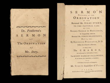
1771 Colonial America 1ed Patriot Sermon SALEM Massachusetts Pemberton StorySchilb Antiquarian Rare Books4.8(421)See Sold PriceMar 10, 2024
18TH C. SPANISH COLONIAL SANTOS, SOUTH-WEST AMERICAThomaston Place Auction Galleries4.4(386)See Sold PriceFeb 24, 2024
1849 Mitchell School ATLAS 24 MAPS America Holy Land France Africa Egypt AsiaSchilb Antiquarian Rare Books4.8(421)See Sold PriceMar 31, 2024
Two (2) Antique 18th C. Copper Engraved Framed Maps - America & EuropeMagnusson Art Group4.5(46)See Sold PriceMar 14, 2024
Arrowsmith & Lewis - Map of North AmericaTrillium Antique Prints & Rare Books4.5(30)See Sold PriceFeb 24, 2024
Map: An 18thC engraved and hand coloured map of North America and South America, titled DeClaydon Auctioneers Ltd4.3(125)See Sold PriceFeb 26, 2024
New and Correct Map of North America With the West India Islands,Jasper524.5(9.8k)See Sold PriceFeb 27, 2024
Colonial West Africa. Nigeria Cameroon Congo. British German. TIMES 1900 mapJasper524.5(9.8k)See Sold PriceFeb 28, 2024
Colonial West Africa. Nigeria Cameroon Congo. British German. TIMES 1895 mapJasper524.5(9.8k)See Sold PriceFeb 28, 2024
Buffon, Vaugody & Bell 1785 America - Map of the New ContinentAlbion Auctions4.6(336)See Sold PriceMar 01, 2024
John Singleton Copley - A Boy with a Flying SquirrelFederal Assets Auctioneers4.4(411)See Sold PriceFeb 28, 2024