Map of Castle of LimerickMap of Castle of Limerick, Cartographer Thomas Stafford/George Carew, circa 1633 Size: 30 x 38 cm.See Sold Price
IRELAND. St Patrick's Dublin Killarney round towerTITLE/CONTENT OF MAP: 'Ireland' Vignettes: St Patrick's, Dublin; Limerick Castle; The Holy Well; Ross Castle, Lake of Killarney; Round Tower, Wicklow. Shows the four provinces of Munster, Leinster, CoSee Sold Price
IRELAND. St Patrick's Dublin Killarney round towerTITLE/CONTENT OF MAP: 'Ireland' Vignettes: St Patrick's, Dublin; Limerick Castle; The Holy Well; Ross Castle, Lake of Killarney; Round Tower, Wicklow. Shows the four provinces of Munster, Leinster, CoSee Sold Price
IRELAND. St Patrick's Dublin Killarney round towerTITLE/CONTENT OF MAP: 'Ireland' Vignettes: St Patrick's, Dublin; Limerick Castle; The Holy Well; Ross Castle, Lake of Killarney; Round Tower, Wicklow. Shows the four provinces of Munster, Leinster, CoSee Sold Price
IRELAND. St Patrick's Dublin Killarney round towerTITLE/CONTENT OF MAP: 'Ireland' Vignettes: St Patrick's, Dublin; Limerick Castle; The Holy Well; Ross Castle, Lake of Killarney; Round Tower, Wicklow. Shows the four provinces of Munster, Leinster, CoSee Sold Price
IRELAND. St Patrick's Dublin Killarney round towerTITLE/CONTENT OF MAP: 'Ireland' Vignettes: St Patrick's, Dublin; Limerick Castle; The Holy Well; Ross Castle, Lake of Killarney; Round Tower, Wicklow. Shows the four provinces of Munster, Leinster, CoSee Sold Price
IRELAND: St Patrick's Dublin Killarney round towerTITLE/CONTENT OF MAP: 'Ireland' Vignettes: St Patrick's, Dublin; Limerick Castle; The Holy Well; Ross Castle, Lake of Killarney; Round Tower, Wicklow. Shows the four provinces of Munster, Leinster, CoSee Sold Price
SoldGerman book KULTUR BILDER cigarette albumI-11 "DEUTSCHE KULTUR BILDER" Large German cigarette card album. Multicolor large front and back covers with medieval map, castle, coats-of-arms, etc. 14 1/2" x 12 1/2" with 300 color cards (completeSee Sold Price
SoldJ.W. Carey, watercolour, view at Desmond Castle,J.W. Carey, watercolour, view at Desmond Castle, Limerick, signed and dated 1929, 10ins x 13ins, gilt framedSee Sold Price
German book DEUTSCHE KULTUR BILDER cigarette cardI-5 "DEUTSCHE KULTUR BILDER" - German cigarette card album. Multicolored large front and back covers with medieval map, castles, coats-of-arms, etc. 14 ½" x 12 ½". With 300 color cards (complete setSee Sold Price
SoldLot of Scotland ViewsThirty-four postcard views of Scotland and the clans. Lot includes maps, castles and heraldic emblems.See Sold Price
SoldMap Town & Castle of Lerida , Belgium, Flanders,Copper plate engrv 14" x 18", From Tindals Continuation of Rapin's History of EnglandSee Sold Price
1941 General Hwy Map, New Castle County, DEDescription: Vintage 1941 General Highway Map, New Castle County, Delaware. Prepared by the Delaware State Highway Department, in cooperation with the Public Roads Administration. Material: paper. MeaSee Sold Price
SoldGERMAN ENGRAVED MAP depicting castle high on a hilGERMAN ENGRAVED MAP depicting castle high on a hill with village below, historical story line u.r. signed Wursburg, center portion cut out. Over all 20 1/2 in. by 14 1/2 in. Written with pen & ink onSee Sold Price
SoldCOUNTY MAP OF LIMERICKtaken from Samuel Lewis "Topographical Dictionary of Ireland" 1837. The dictionary was the first detailed study of its kind and as it was published before the famine it is an important document of itsSee Sold Price
SoldSCOTLAND general map showing castles & kirks. Railways.TITLE/CONTENT OF MAP: 'SCOTLAND' The map shows some early railways The top image on the right hand side shows the entire map. To view a close up of the map showing the level of printed detail, pleaseSee Sold Price
SoldFramed maps and Castle PrintsFramed maps and castle prints..All sales are subject to Bremo Auctions Terms & Conditions. Please review before bidding.See Sold Price
SCOTLAND. General map showing castles & kirks. SDUKTITLE/CONTENT OF MAP: 'SCOTLAND' The top image on the right hand side shows the entire map. To view a close up of the map showing the level of printed detail, please click on the bottom image on the rSee Sold Price
SCOTLAND. General map showing castles & kirks.TITLE/CONTENT OF MAP: 'SCOTLAND' The map shows some early railways The top image on the right hand side shows the entire map. To view a close up of the map showing the level of printed detail, pleaseSee Sold Price
SCOTLAND. General map showing castles & kirks.Reserve Reduced! TITLE/CONTENT OF MAP: 'SCOTLAND' The map shows some early railways DATE PRINTED: 1845 IMAGE SIZE: Approx 41.5 x 34.0cm, 16.25 x 13.5 inches (Large) TYPE: Antique steel engraved map wiSee Sold Price
SCOTLAND. General map showing castles & kirks. SDUKTITLE/CONTENT OF MAP: 'SCOTLAND' DATE PRINTED: 1874 IMAGE SIZE: Approx 42.0 x 33.5cm, 16.5 x 13.25 inches (Large) TYPE: Antique steel engraved map with original outline hand colouring CONDITION: Good;See Sold Price
SoldJEREMIAH HODGES MULCAHY (1820- 1886)Untitled (depicting Carrigogunnell Castle, in Limerick, Ireland. with figures in the back ground.), 1857.Dimensions: canvas H 19.25" x W 28" Condition : Good. Re-lined and cleaned. Remnants of paper sSee Sold Price
Sold11 silver souvenir spoons, IrelandGrouping of 11 silver souvenir spoons from Ireland, five with enamel work, including Blarney Castle, Dublin, Limerick, Killarney, and Belfast. Longest spoon measures 5 1/8" long, total weight of all pSee Sold Price
17TH C. MAP OF THE BERKSHIRES BY JOHN SPEED, FRAMEDThomaston Place Auction Galleries4.4(386)See Sold PriceFeb 24, 2024
Peltro, William Tompkins (Engraver) :ENGRAVING - ST. PATRICKS CHURCH & ARMOURY AT PEELE CASTLE, INLuis Porretta Fine Arts4.3(10)See Sold PriceMar 02, 2024
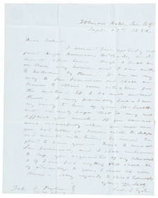
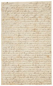
1850 California gold rush letter from Fred Snyder to brotherPBA Galleries4.7(381)See Sold PriceMar 07, 2024
WESTERN AFRICA.Kong Mountains.Caravan routes.Slave Coast.TALLIS/RAPKIN 1849 mapJasper524.5(9.8k)See Sold PriceFeb 28, 2024
WESTERN AFRICA.Kong Mountains.Caravan routes.Slave Coast.TALLIS/RAPKIN 1851 mapJasper524.5(9.8k)See Sold PriceFeb 28, 2024