Map of Cahir CastleMap of Cahir Castle, taken by the Earl of Effex in Anno 1599, page 42 and 43, Dated 1599, Cartographer Thomas Stafford/George ,Carew, circa 1633 Size: 30 x 38 cm.See Sold Price
SoldArtist Unknown (British, 17th Century) Cahir CastleArtist Unknown (British, 17th Century) Cahir Castle Taken by the Earle of Essex in Anno 1599. Etching 11.5" x 14.25" Frame: 18.5" x 21.25"See Sold Price
SoldGerman book KULTUR BILDER cigarette albumI-11 "DEUTSCHE KULTUR BILDER" Large German cigarette card album. Multicolor large front and back covers with medieval map, castle, coats-of-arms, etc. 14 1/2" x 12 1/2" with 300 color cards (completeSee Sold Price
Definitives: Architecture £1 CCP3, spectacular1982 Cahir Castle £1 on CCP3, bottom left corner block of 15, four stamps in the centre with an almost complete dry-print of brown affecting four stamps, leaving only a hint of parts of the CastlSee Sold Price
SoldArchitecture: £1 postal forgery1984 Architecture £1 Cahir Castle postal forgery on ordinary paper, line-perf. 15, complete horizontal strip of 5, u/m mint, better centred than usual. SG 550 F, Mi. 502PFä.See Sold Price
German book DEUTSCHE KULTUR BILDER cigarette cardI-5 "DEUTSCHE KULTUR BILDER" - German cigarette card album. Multicolored large front and back covers with medieval map, castles, coats-of-arms, etc. 14 ½" x 12 ½". With 300 color cards (complete setSee Sold Price
SoldLot of Scotland ViewsThirty-four postcard views of Scotland and the clans. Lot includes maps, castles and heraldic emblems.See Sold Price
SoldMap Town & Castle of Lerida , Belgium, Flanders,Copper plate engrv 14" x 18", From Tindals Continuation of Rapin's History of EnglandSee Sold Price
1941 General Hwy Map, New Castle County, DEDescription: Vintage 1941 General Highway Map, New Castle County, Delaware. Prepared by the Delaware State Highway Department, in cooperation with the Public Roads Administration. Material: paper. MeaSee Sold Price
Map of Castle of LimerickMap of Castle of Limerick, Cartographer Thomas Stafford/George Carew, circa 1633 Size: 30 x 38 cm.See Sold Price
SoldGERMAN ENGRAVED MAP depicting castle high on a hilGERMAN ENGRAVED MAP depicting castle high on a hill with village below, historical story line u.r. signed Wursburg, center portion cut out. Over all 20 1/2 in. by 14 1/2 in. Written with pen & ink onSee Sold Price
SoldSCOTLAND general map showing castles & kirks. Railways.TITLE/CONTENT OF MAP: 'SCOTLAND' The map shows some early railways The top image on the right hand side shows the entire map. To view a close up of the map showing the level of printed detail, pleaseSee Sold Price
SoldFramed maps and Castle PrintsFramed maps and castle prints..All sales are subject to Bremo Auctions Terms & Conditions. Please review before bidding.See Sold Price
SCOTLAND. General map showing castles & kirks. SDUKTITLE/CONTENT OF MAP: 'SCOTLAND' The top image on the right hand side shows the entire map. To view a close up of the map showing the level of printed detail, please click on the bottom image on the rSee Sold Price
SCOTLAND. General map showing castles & kirks.TITLE/CONTENT OF MAP: 'SCOTLAND' The map shows some early railways The top image on the right hand side shows the entire map. To view a close up of the map showing the level of printed detail, pleaseSee Sold Price
SCOTLAND. General map showing castles & kirks.Reserve Reduced! TITLE/CONTENT OF MAP: 'SCOTLAND' The map shows some early railways DATE PRINTED: 1845 IMAGE SIZE: Approx 41.5 x 34.0cm, 16.25 x 13.5 inches (Large) TYPE: Antique steel engraved map wiSee Sold Price
SCOTLAND. General map showing castles & kirks. SDUKTITLE/CONTENT OF MAP: 'SCOTLAND' DATE PRINTED: 1874 IMAGE SIZE: Approx 42.0 x 33.5cm, 16.5 x 13.25 inches (Large) TYPE: Antique steel engraved map with original outline hand colouring CONDITION: Good;See Sold Price
SoldPlan of Choisy le Roy, 1783Plan Des Chateaux et Jardins de Choise Le Roy. Map of castle and gardens of Choise Le Roy, Marne, 1783. Framed in two panels with central matting covering the seam of the book binding. Frame 37.5 x 52See Sold Price
SoldTopo Map group, 1:24,000 series, 7.5 minute (112332)About 120 maps of the 7.5 minute series. Modern, c 1960-2000. These cost in excess of $6 each today. This group also includes three other maps, Kelso- Castle Rock, Mineral Lake and New Castle Hills. PSee Sold Price
Beers & Pomeroy: Antique Map of New Castle, DelawareTitle/Content of Map: New Castle, Delaware 1868 Date Printed: 1868 Cartographer: Beers & Pomeroy Material/Medium: Lithograph Size: 20" x 21" Original hand colored lithograph by Beers & Pomeroy, 1868.See Sold Price
SoldAntique Map Of German CastleMeasuring 18" X 21". Framed. Shipping: We are unable to ship this item. Please contact our local UPS Store, store1152@theupsstore.com, or the Packaging Store, hello@packandshipnow.com, for a quote. PlSee Sold Price
SoldFramed Map Of North Castle New YorkFramed Map Of North Castle New York. Framed in black toned frame and cream / brown double mat. Not examined out of frame. Some spots on map. Wall art, home decor, home accessory. Measures approx 24 inSee Sold Price
Antique Map Of German CastleMeasuring 18" X 21". Shipping: We are unable to ship this item. Please contact our local UPS Store, store1152@theupsstore.com, for a quote. Please be sure and include your shipping address, a descriptSee Sold Price
17TH C. MAP OF THE BERKSHIRES BY JOHN SPEED, FRAMEDThomaston Place Auction Galleries4.4(386)See Sold PriceFeb 24, 2024
Peltro, William Tompkins (Engraver) :ENGRAVING - ST. PATRICKS CHURCH & ARMOURY AT PEELE CASTLE, INLuis Porretta Fine Arts4.3(10)See Sold PriceMar 02, 2024
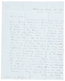
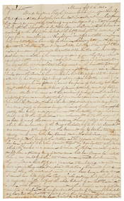
1850 California gold rush letter from Fred Snyder to brotherPBA Galleries4.7(381)See Sold PriceMar 07, 2024
WESTERN AFRICA.Kong Mountains.Caravan routes.Slave Coast.TALLIS/RAPKIN 1849 mapJasper524.5(9.8k)See Sold PriceFeb 28, 2024
WESTERN AFRICA.Kong Mountains.Caravan routes.Slave Coast.TALLIS/RAPKIN 1851 mapJasper524.5(9.8k)See Sold PriceFeb 28, 2024