The World And It's Peoples Photographed And Described 1910 Folio SizeNorth American Artifact Auctions4.6(184)See Sold PriceApr 20, 2024
Vintage 1936 Alaska Steamship Co. Map - AlaskaThis map depicts the Territory of Alaska as it appeared in 1936. The map was made by the Alaska Steamship Co. to show its route to Alaska. Also included on the map are some facts about Alaska, such asSee Sold Price
Mine Related Maps, Alaska, c 1900-1910 (112192)Four maps from the files of engineer J.L. McPherson. Blueline of Wrangell recording District, 1911, about 12 x 18"; black ink on linen map of the Tombstone Lode, 1911, about 10 x 14", probably at NomeSee Sold Price
SoldMitchell: Antique Map of Alaska, 1869Title/Content of Map: Alaska by Mitchell Date Printed: 1869 Cartographer: Augustus S. Mitchell Material/Medium: Paper Size: 12" x 15" Hand colored engraved Map. From 'Mitchell's New General Atlas.' PuSee Sold Price
Rand McNally Indexed Pocket Map of Alaska, 1920Map: Alaska - Rand McNally Indexed Pocket Map Tourists' And Shippers' Guide Maker: Rand, McNally & Co Date: 1920 Size: Pocket - 18.8 inches high x 25.3 inches wide Detailed map with index on reverse.See Sold Price
Britannica Map of Alaska & Isles, 1903Title/Content of Map: 'Alaska; Inset map of Western Portion of Aleutian Islands, Sitka, Glacier Bay, and Vicinity' Date Printed: 1903 Image Size: Approx 28.0 x 39.0cm, 11 x 15.25 inches (Large); PleasSee Sold Price
SoldALASKA FOUR BOOKLETS BOUND VOL 1890'SALASKA, FOUR BOOKLETS BOUND IN ONE VOLUME. RE: ALASKA: INCLUDES "MAP OF ALASKA" SHOWING KNOWN GOLD BEARING ROCKS, WASHINGTON 1898. 44 PGS WITH LARGE FOLD OUT MAPS. "ALASKA HANDBOOK 84", WASHINGTON 189See Sold Price
Alaska 1891Title/Content of Map: Alaska 1891 Date Printed: 1891 Material/Medium: paper Size: approx. 11x14 inches Additional Info: Cram's Unrivaled Atlas of the World. Grand New Census Edition Reserve: $25.00 ShSee Sold Price
Caamano Manuscript Map of Alaska[Map, Alaska, Pacific] CAAMANO, Jacinto (1759-1825). Manuscript Chart of Bucareli Sound, Alaska (Scale in Nautical Miles). Ink on paper. Spain, c. 1792. 21 1/2" x 17 3/4" sheet, 31" x 28" framed. A RASee Sold Price
Alaska map with native land protestsHeading: (Map - Alaska) Author: Title: Native Protest Map Place Published: [Washington, D.C.] Publisher: Date Published: 1968 Description: Blue line map (or xerographic?).See Sold Price
McNally: Map of Alaska, 1920Map: Alaska Rand, McNally Indexed Pocket Map Tourists' And Shippers' Guide. Alaska Pocket Map, Tourists' and Shippers' Guide 1920 Date: 1920 Authors: RAND, MCNALLY & CO., RAND, MCNALLY & CO. PublisherSee Sold Price
Alaska 1897Title/Content of Map: Alaska 1897 Date Printed: 1897 Material/Medium: Paper Size: approx 22x14.5 inches Additional Info: Cram's Universal Atlas Reserve: $25.00 Shipping: Domestic: Flat-rate of $15.00See Sold Price
SoldAlaskan Gold Rush map and how-to, 1898Heading: (Klondike Gold Rush) Author: Title: The "Map of Maps" Alaska. Yukon, Cariboo, Omineca, Cassiar, and a Portio of the Kootenay Gold Fields Place Published: Salt Lake City, Utah et al. PublisheSee Sold Price
Alaska 1891Title/Content of Map: Alaska 1891 Date Printed: 1891 Material/Medium: paper Size: approx. 11x14 inches Additional Info: Cram's Unrivaled Atlas of the World. Grand New Census Edition Reserve: $25.00 ShSee Sold Price
Alaska 1897Title/Content of Map: Alaska 1897 Date Printed: 1897 Material/Medium: Paper Size: approx 22x14.5 inches Cram's Universal Atlas Reserve: $25.00 Shipping: Domestic: Flat-rate of $15.00 to anywhere witSee Sold Price
Alaska 1891Title/Content of Map: Alaska 1891 Date Printed: 1891 Material/Medium: paper Size: approx. 11x14 inches Additional Info: Cram's Unrivaled Atlas of the World. Grand New Census Edition Reserve: $20.00 ShSee Sold Price
Alaska 1897Title/Content of Map: Alaska 1897 Date Printed: 1897 Material/Medium: Paper Size: approx 22x14.5 inches Additional Info: Cram's Universal Atlas Reserve: $25.00 Shipping: Domestic: Flat-rate of $15.00�See Sold Price
Alaska 1897Title/Content of Map: Alaska 1897 Date Printed: 1897 Material/Medium: Paper Size: approx 22x14.5 inches Additional Info: Cram's Universal Atlas Reserve: $25.00 Shipping: Domestic: Flat-rate of $15.00See Sold Price
Alaska and Adjoining Territory 1869.Title/Content of Map: Alaska and Adjoining Territory 1869. Date Printed: 1869 Cartographer: LINDENKOHL, H. Size: 23.75X33.5 "The Yukon River, ranges of mountains, shores of Norton Sound and many featuSee Sold Price
SoldAlaska 1897Title/Content of Map: Alaska 1897 Date Printed: 1897 Material/Medium: Paper Size: approx 22x14.5 inches Cram's Universal Atlas Reserve: $30.00 Shipping: Domestic: Flat-rate of $15.00 to anywhere witSee Sold Price
Alaska 1891Title/Content of Map: Alaska 1891 Date Printed: 1891 Material/Medium: paper Size: approx. 11x14 inches Additional Info: Cram's Unrivaled Atlas of the World. Grand New Census Edition Reserve: $25.00 ShSee Sold Price
Alaska | HawaiiTitle/Content of Map: Alaska | Hawaii Publication Date: 1904 ca. Cartographer: CRAM, GEORGE F. Publisher: GEO. F. CRAM 1904 ca. CHICAGO Size: Folio – 16.25 H x 22.25 W Inches In: Cram's indexed CounSee Sold Price
Rand McNally: Antique Map of Alaska, 1898Title/Content of Map: Alaska, 1898 Date Printed: 1898 Cartographer: Rand McNally Material/Medium: Lithograph Size: 18" x 24 1/2" Original lithograph published by Rand McNally, 1898. Insets show KlondiSee Sold Price
SoldAlaska, Utah and Arizona Ephemera (106394)Lots of ephemera including approx 20 unused Utah envelopes, WW 2 Alaska folded newspapers, Western maps, Alaska and Arizona booklet and more.Geff Pollock Collection Date: State/Country: City/County:See Sold Price
Railway Routes in Alaska w/19 mapsHeading: (Maps - Alaska) Author: Title: Railway Routes in Alaska: Message From the President of the United States, Transmitting Maps and Profiles to Accompany the Report of the Alaska Railroad CommisSee Sold Price
Oregon Short Line RR April 1899 Public TimetableJM Hobby Supply and Railroad Artifact Auctions4.4(126)See Sold PriceFeb 24, 2024
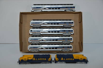
Alaska RR McKinley Explorer 7 Unit Diesel Loco and Passenger Car Set-Bachmann-HO ScaleJM Hobby Supply and Railroad Artifact Auctions4.4(126)See Sold PriceFeb 25, 2024
LATE 17TH C. FRENCH MAP OF THE NEW WORLD BY ALEXIS-HUBERT JAILLOT (1632-1712)Thomaston Place Auction Galleries4.4(389)See Sold PriceFeb 24, 2024
18TH C. ANTIQUE MAP: FRENCH & INDIAN WAR, FRAMEDThomaston Place Auction Galleries4.4(389)See Sold PriceFeb 24, 2024
Keith Haring - Ink on New York Map, Best Buddies, Inscribed, Signed, and DatedSapphire Auction Gallery4.1(67)See Sold PriceMar 02, 2024
Inuit-Made Catholic Altarpiece, Alaska, Early 20th C.Material Culture4.6(769)See Sold PriceFeb 29, 2024
Rand McNally Railroad Map Cabinet w/ 21 Railroad MapsRail & Road Auctions4.6(165)See Sold PriceMar 08, 2024
Putnam - First Map of the State of Ohio by Rufus PutnamTrillium Antique Prints & Rare Books4.5(30)See Sold PriceFeb 24, 2024