Sold[Map Miscellany]. 19 Maps. Sizes vary 7.5 x 8.5 t[Map Miscellany]. 19 Maps. Sizes vary 7.5 x 8.5 to 22 x 17. Mostly 19th Century Colton & Johnson maps; many in color, including Africa, Germany, Northern [Polar] Regions, South America, Sweden. This iSee Sold Price
Sold1745 MAP OF NORMANDY BY THE HOMANN FAMILYHand-colored map with an elaborate cartouche. Sight size 19.75 x 23.5 inches, overall 32 x 31.5.See Sold Price
SoldJohannes Kip After L. Knyff Antique Map of YorkJohannes Kip After Leonard Knyff (1650-1722) antique map of York. Measures 13.75" x 19" (plate size) and 18.75" x 22 3/8" (sheet size). Vg+-Ex/Ex condition. Unframed, loose and not mounted or glued doSee Sold Price
SoldRand-Mcnally New Commercial Atlas Map of New JerseyReserve Reduced! Title: Rand-Mcnally New Commercial Atlas Map of New Jersey Publication Date: 1912 Cartographer: RAND-MCNALLY & COMPANY Publisher: RAND MCNALLY & CO. Size: 25.75 X 19 Page 44-45 from TSee Sold Price
Atlantic & Pacific Junction. Topographical Map of aTitle: Atlantic & Pacific Junction. Topographical Map of a Portion of the Isthmus Of Darien Publication Date: 1854 Cartographer: LISBORNE, LIONEL Publisher: U.S. SENATE Size: 13.75 X 19.25 AdditionalSee Sold Price
Map of IowaTitle/Content of Map: Map of Iowa Date: 1881 Cartographer: LOEHNES, A. Publisher: H.R. PAGE & CO. Size: 12.75 x 19 inches Folds into violet coated board covers, imprinted "Indexed map of Iowa ... pricSee Sold Price
Robert de Vaugondy - Map of Champagne, FranceArtist: de Vaugondy, Robert (French, 1688-1766) Title: Map of Champagne, France from Atlas Universel Date: 1757 Medium: Hand-colored engraving Dimensions: 19" x 23.25" (plate size), 19.75" x 26" (sheeSee Sold Price
SoldRAND McNALLY 1905 MAP OF RAILROAD MAP OF MISSOURISight size 19.75 x 27.25 inches, 29.75 x 35.25 inches. Professionally matted in archival material.See Sold Price
Africae nova Tabula - By Henricus HondiusTitle: Africae nova Tabula - By Henricus Hondius Date/Period: 1631 Materials: Copper Plate Dimensions: 19.75 x 14.85 inches Richly ornamented map of Africa’s continent. The general geography for thiSee Sold Price
SoldSpain, Jean-Baptiste Louis Clouet 1787Map: De l'Espagne en General Maker: Jean-Baptiste Louis Clouet From Géographie Moderne Origin: Paris Date: 1787 Medium: Engraving hand-colored at publication Sheet Size: 19.75 x 26.75 inches No ReserSee Sold Price
SoldJean-Baptiste Louis Clouet: Central Asia 1787Map: Central Asia De La Tartarie Maker: Jean-Baptiste Louis Clouet From Géographie Moderne Origin: Paris Date: 1787 Medium: Engraving hand-colored at publication Sheet Size: 19.75 x 26.75 inches No RSee Sold Price
SoldFrance, Jean-Baptiste Louis Clouet 1787Map: La France Mineralogique Maker: Jean-Baptiste Louis Clouet From Géographie Moderne Origin: Paris Date: 1787 Medium: Engraving hand-colored at publication. Sheet Size: 19.75 x 26.75 inches No ReseSee Sold Price
SoldJean-Baptiste Louis Clouet: North Africa 1787Map: Barbary Coast, North Africa Maker: Jean-Baptiste Louis Clouet From Géographie Moderne Origin: Paris Date: 1787 Medium: Engraving hand-colored at publication Sheet Size: 19.75 x 26.75 inches No RSee Sold Price
SoldEarly Color Map in FacsimileEarly color map by Blaeuw of Asia, this example a high quality reproduction. Image size 15.75 in x 21.5 in. Sheet size 19.5 in x 25 in. Condition: Superb! Unframed, loose and not mounted or glued downSee Sold Price
Johnson's Framed Map Wisconsin, MichiganJohnson's Map of Wisconsin and Michigan, framed size 28" x 19.75"See Sold Price
SoldMap of "Edenburgum Vugro Edenburg", Janssen c.1650Map of "Edenburgum Vulgro Edenburg" with original book text on verso (Latin). Taped at center of fold and sheet edges on verso. Measures 15.75" x 19.25" sheet size. Written in pencil verso is JanssenSee Sold Price
SoldMap of the Holy Land - 1782Map of the Holy Land - 1782 Lattre Handcolored Etching 1782 - France Map of the Holy Lands Image Size: 26.5 x 19.5 in. Overall Framed Size: 36 x 28.75 in. Framed behind glass.See Sold Price
SoldVintage Air France Airline Travel Routes World MapVintage Air France Airline Travel Routes World Map, by Lucien Boucher (French, 1889-1971) color offset, C.1948. Framed. Size: 19.5'' x 33.75'', 50 x 86 cm (sight); 24.5'' x 39'', 62 x 99 cm (frame).See Sold Price
SoldA 1913 COMMERCIAL & RAILROAD MAP OF CHICAGORand, McNally 'New Commercial Atlas Map of Chicago District.' Professionally matted, 24.75 x 19 inch sight size.See Sold Price
SoldFramed Wm. Blaeu Nova Belgica Et Anglia MapLovely example of the Wm. Blaeu map of the Dutch & British colonies in North America, C. 1650. Sight size, 15.25" x 19.75". "Nova Belgica Et Anglia Nova", handwritten (?) 1650 below. Colored. In R. VaSee Sold Price
SoldTwo Diderot Maps (California / Mexico) 1751-1780Two Diderot Maps (California & Northwest and Mexico) 1751 - 1780. Measure approximately 11 3/8" x 12.75 to 14" image sizes and 16" x 19" sheet sizes. Creased at fold lines. Unframed, loose and not gluSee Sold Price
Sold18th/19th C. Map18th/19th C. map. "Moraviae" in sex circulos Divisae quos Mandato Caesareo. Editore I oh. Bapt. Momanno Noriberge. Colorful and intricate cartouche. Image size 19" H x 22.75" in gilt frame.See Sold Price
SoldAntique Map of Amsterdam by OttensAntique Map of Amsterdam by Reinier & Joshua Ottens. Size: 19.25" x 23", 49 x 58 cm (sight); 25.75" x 29.25", 65 x 74 cm (frame). Provenance: Private New York Estate.See Sold Price
Alighiero Boetti - Map - 1985Reference #: ULNR114 Artist Name: Boetti, Alighiero Title: Map Medium: Offset Lithograph Edition Size: Unknown Year: 1985 Framed: No Paper Size: 28.5 x 35.5 inches Image Size: 19.25 x 29.75 inches ConSee Sold Price
AIME EDMOND DALLEMAGNE (1882-1971) Engraving Paris Numbered & Pencil SignedLuis Porretta Fine Arts4.3(10)See Sold PriceMar 02, 2024
EARLY COLONIAL WEST AFRICA. Empires of Sokoto Gando Mas.Tribes.Fellatah 1882 mapJasper524.5(9.9k)See Sold PriceFeb 28, 2024
AFRICA. Antiqua; Rome Carthage, start Punic War 1908 old antique map chartJasper524.5(9.9k)See Sold PriceFeb 28, 2024
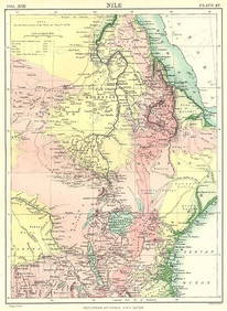
NILE VALLEY. Sudan Tanzania Ethiopia Uganda Lake Victoria. Britannica. 1898 mapJasper524.5(9.9k)See Sold PriceFeb 28, 2024
Colonial Africa. British German French Spanish Portuguese Italian TIMES 1900 mapJasper524.5(9.9k)See Sold PriceFeb 28, 2024
WEST AFRICA. French. Gold Coast Ghana. inset Gambia; Sierra Leone 1920 mapJasper524.5(9.9k)See Sold PriceFeb 28, 2024
AFRICA. European Possessions in Central; map of Zanzibar 1907 old antiqueJasper524.5(9.9k)See Sold PriceFeb 28, 2024
COLONIAL CENTRAL AFRICA. Congo German East Africa Rhodesia. BARTHOLOMEW 1898 mapJasper524.5(9.9k)See Sold PriceFeb 28, 2024
Carte d'Afrique. Africa Soudan Zanzibar. LAPIE 1831 old antique map plan chartJasper524.5(9.9k)See Sold PriceFeb 28, 2024
NORTH AFRICA.Afrika;Atlaslander Morocco Algeria Marokko Algerien 1958 old mapJasper524.5(9.9k)See Sold PriceFeb 28, 2024
Afrique. Pays des Hottentots #50. Namibia South Africa VANDERMAELEN 1827 mapJasper524.5(9.9k)See Sold PriceFeb 28, 2024
Africa inc. discoveries of Livingstone Barth Vogel Chadda Exp. SWANSTON 1860 mapJasper524.5(9.9k)See Sold PriceFeb 28, 2024
FRENCH WEST AFRICA. Afrique Occidentale Française. Plan of Niger floods 1938 mapJasper524.5(9.9k)See Sold PriceFeb 28, 2024
Carte de l'Afrique propre, de la Numidie… North Africa. LAPIE 1829 old mapJasper524.5(9.9k)See Sold PriceFeb 28, 2024
Coste Orientale d’Afrique…' East Africa Kenya Tanzania Somalia. BELLIN 1746 mapJasper524.5(9.9k)See Sold PriceFeb 28, 2024
Carte du Golfe de Guinée. Gulf of Guinea Nigeria Cameroon BELLIN/SCHLEY 1748 mapJasper524.5(9.9k)See Sold PriceFeb 28, 2024
SOUTHERN AFRICA & MALAY ARCHIPELAGO. Cape Colony Indonesia &c. BUTLER 1888 mapJasper524.5(9.9k)See Sold PriceFeb 28, 2024
NAMIBIA. South West Africa protectorate. HARMSWORTH 1920 old antique map chartJasper524.5(9.9k)See Sold PriceFeb 28, 2024
Colonial Africa. British German French Spanish Portuguese Italian TIMES 1895 mapJasper524.5(9.9k)See Sold PriceFeb 28, 2024
EARLY COLONIAL WEST AFRICA. Empires of Sokoto Gando Mas.Tribes.Fellatah 1886 mapJasper524.5(9.9k)See Sold PriceFeb 28, 2024
Operation Torch Nov 1942-May 1943. World War 2. Western Mediterranean 1966 mapJasper524.5(9.9k)See Sold PriceFeb 28, 2024
Africa by Arrowsmith & Lewis 1812 old antique vintage map plan chartJasper524.5(9.9k)See Sold PriceFeb 28, 2024


![[Map Miscellany]. 19 Maps. Sizes vary 7.5 x 8.5 t First Image](https://p1.liveauctioneers.com/dist/images/placeholder.jpg?height=282&quality=95&width=282)
![[Map Miscellany]. 19 Maps. Sizes vary 7.5 x 8.5 t (1 of 0)](https://p1.liveauctioneers.com/dist/images/placeholder.jpg?height=282&quality=70)
![[Map Miscellany]. 19 Maps. Sizes vary 7.5 x 8.5 t First Image](https://p1.liveauctioneers.com/dist/images/placeholder.jpg?height=282&quality=1&width=282)