(MAP) JANSSON, JAN. Hungaria Regnum. Amsterdam, ca.(MAP) JANSSON, JAN Hungaria Regnum. Amsterdam, ca. 1650. Engraved map of Hungary with later hand coloring, vignette title with allegorical figures to lower left. Latin text to verso. Framed and mattedSee Sold Price
SoldJAN JANSSON MAP MAKERTitled: "Fezzae et Marocchi Regna Africae Celeberrima" Amsterdam / ca.1660, Map Maker: Jan Jansson Hand Colored Dimensions: H 20" x W 15". Condition: Good, has some tears on the sides and center foldSee Sold Price
SoldJansson (Jan) Hungaria RegnumJansson (Jan) Hungaria Regnum,engraved map with hand-colouring, 425 x 515mm., central vertical fold, split through the image, French text verso, pale browning, [Amsterdam], c.1650 De L'IsleSee Sold Price
Sold1 piece. Hand-Colored Engraved Map. Jansson, Jan.1 piece. Hand-Colored Engraved Map. Jansson, Jan. Mar del Nort." [Amsterdam], [ca. 1650.] 17 1/4 x 22 3/8 inches; 438 x 568 mm, narrow margins. Browned & mounted to bd. Orig. color. Framed. The NorthSee Sold Price
Sold1 piece. Partly Hand-Colored Engraved Map. [Janss1 piece. Partly Hand-Colored Engraved Map. [Jansson, Jan.] Magnae Britanniae et Hiberniae, Nova Descripto." Amsterdam, [ca. 1638-1646]. 17 x 21 3/8 inches (430 x 540 mm). Browned, split along center fSee Sold Price
Sold(MAP) JANSSON, JAN. Buckingamiae Comitatus cum(MAP) JANSSON, JAN Buckingamiae Comitatus cum Bedfordiensi; vulgo Buckingamshire and Bedfordshire. Amsterdam, ca. 1645. Double-page engraved map hand-colored in outline. With decorative cartouche andSee Sold Price
Sold(MAP) JANSSON, JAN. Principatus Walliae Pars Borealis(MAP) JANSSON, JAN Principatus Walliae Pars Borealis Vulgo North Wales. Amsterdam, ca. 1650. Double-page engraved map with later hand-coloring. Depicting North and South Wales, decorative cartouches aSee Sold Price
SoldJansson (Jan) Hungaria RegnumJansson (Jan) Hungaria Regnum,Hungary with vignette title of allegorical figures lower left, engraved map with original hand-colouring, 425 x 515mm., Latin text verso, splitting at head and foSee Sold Price
SoldMap or Table of Nautical WindsTabula Anemographica seu Pyxis Nautica Ventorum nomina sex linguis repraesentans. Jansson, Joan (Jan), Amsterdam, ca 1650. Plate approx. 17.25 x 21.6 in. (44 x 55cm). Before magnetic compasses, navigSee Sold Price
SoldMap "Orbis Terrarum Veteribus..."Orbis Terrarum Veteribus Cogniti Typus Geographicus Jansson, Jan. (1588-1664), Amsterdam, ca 1650. Approx. 18.5 x 22.5 in. (plate impression approx. 16 x 20 in.), currently matted and shrink wrappeSee Sold Price
Sinus Gangeticus, Vulgo Golfo de Bengala. NovaBy Jan Jansson, Amsterdam, ca. 1657 In Jansson’s Atlas Maior 47 cm x 54 cm Watermarked paper. Original color (outlines of provinces). Small tears outside margins at top and bottom. Title cartouSee Sold Price
[Map of Ireland]. [Jan Jansson, cartographer]. H[Map of Ireland]. [Jan Jansson, cartographer]. Hibernia Regnum Vulgo IrelandSee Sold Price
Hondius Map of Asia*** START PRICE IS THE RESERVE *** [Asia] HONDIUS, Hendrik (1597-1651). Asia recens summa cura delineata. Engraved map with original hand color in outline. Amsterdam: Jan Jansson, ca. 1631. 18 3/4" xSee Sold Price
SoldJan Jansson map of Scotland, c.1640Heading: Author: Jansson, Jan Title: Scotia Regnum Place Published: Amsterdam Publisher: Date Published: c.1640 Description: Copper-engraved map, hand-colored. 38.2x50 cm (See Sold Price
SoldJANSSON, Jan (1588-1664). Insulae Americanae in OceanoJANSSON, Jan (1588-1664). Insulae Americanae in Oceano Septentrionali cum Terris Adjacentibus. [Amsterdam, ca 1640]. Engraved map of the West Indies with hand-coloring, Dutch text on verso, sheet 19 xSee Sold Price
SoldJansson Map of the East Indian Ocean ArchipelagosJan Jansson (1588 - 1664), "Indiae Orientalis Nova Descriptio," Amsterdam, ca. 1630. This hand colored map depicts a section of Southeast Asia, including what is now Laos, Cambodia, Thailand, Vietnam,See Sold Price
Principatus Wallae pars Borealis by Jan Jansson, 17thAmsterdam: ca. 1646, copper engraved map of North Wales including Anglesey, Caernavonshire, Denbighshire, Flintshire, Merioneth and Montgomery. With antique coloring, decorative title cartouche,See Sold Price
SoldJansson (Jan) Anglia RegnumJansson (Jan) Anglia Regnumarmorial title cartouche, with royal arms above, engraved map, 395 x 500mm., French text verso, slight showthrough, Amsterdam, c.1640 § Sanson (Nicolas) Provinces d'See Sold Price
SoldBENG Jansson (Jan) Anglia RegnumBENG Jansson (Jan) Anglia Regnumarmorial title cartouche, with royal arms above, engraved map, 395 x 500mm., French text verso, slight showthrough, Amsterdam, c.1640 § Sanson (Nicolas) PrSee Sold Price
SoldMercator-Hondius Mexico Map ca. 1638Hendrik Hondius (1588-1651), Jan Jansson (1588-1664), and Gerardus Mercator (1512–1594), "Nova Hispania et Nova Galicia," Amsterdam: Hondius & Jansson, ca. 1638. Hand colored map of Mexico fromSee Sold Price
SoldTerra Firma et Novum Regnum Granatense et PopayanJan Jansson / Wilhelm Blaeu, Terra Firma et Novum Regnum Granatense et Popayan, engraving, ca. 1647 , 19.5 x 15.5 19.5 x 15.5See Sold Price
SoldMap, Jansson, Jan, Genova, Amsterdam, c.1635MAP. Author: Jansson, Jan, Riviera di Genova di Ponente, Amsterdam, c.1635, Copper-engraved map, hand-colored. 38.2x49 cm. (15x19¼"). The Italian Riviera from Genoa in the west to the Gulf of Spezz iSee Sold Price
Sold1 piece. Hand Colored Engraved Map. Jansson, Jan1 piece. Hand Colored Engraved Map. Jansson, Jan. "Tabula Italia." Amsterdam, 1640. 18 x 21 1/4 inches; 457 x 540 mm. Margins repaired, small vertical tear at upper right edge. Vignette borders.See Sold Price
1 vol. [Janssonius, Joannes] [Jansson, J1 vol. [Janssonius, Joannes] [Jansson, Jan]. [Novus Atlas.] [Amsterdam], [ca. 1646-1649.] [Vol. IV, Magna Britannia (Camden's Britannia Illustrata).] Folio, contemp. full vellum; somewhat worn & dustSee Sold Price
JAN VAN DER DESYATER c1732 First Edition Thoughts On Sleepless Nights Rare!Luis Porretta Fine Arts4.3(10)See Sold PriceMar 02, 2024
LARGE LATE 17TH C. DUTCH CHART OF CANADA, GREAT LAKES, NEW FRANCE, LABRADOR, HUDSON BAY, BY PIERREThomaston Place Auction Galleries4.4(389)See Sold PriceFeb 24, 2024
EARLY 18TH C. DUTCH CHART OF PACIFIC OCEAN BY FREDERIK DE WIT (1629-1706) WITH CALIFORNIA AS ANThomaston Place Auction Galleries4.4(389)See Sold PriceFeb 24, 2024
EARLY 18TH C. MAP OF ITALY, FRAMEDThomaston Place Auction Galleries4.4(389)See Sold PriceFeb 24, 2024
Hand Colored Map of the city of Amsterdam 1720Global Auctions Company4.3(36)See Sold PriceMar 03, 2024
[MAPS]. DUFOUR, Auguste-Henri (1795-1865). Bound Volume of ...Potter & Potter Auctions4.6(544)See Sold PriceMar 07, 2024
1749-59 21 volumes NETHERLANDS HISTORY ILLUSTRATED antique VELLUM BOUNDJasper524.5(9.8k)See Sold PriceFeb 27, 2024
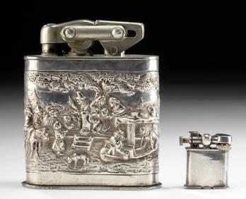
20th C. Mexican & Dutch Silver & Plated Lighters (2)Artemis Fine Arts4.8(1.4k)See Sold PriceFeb 26, 2024


![[Map of Ireland]. [Jan Jansson, cartographer]. H (1 of 1)](https://p1.liveauctioneers.com/906/53015/25432044_1_x.jpg?height=282&quality=70&version=1395428013)


![1 vol. [Janssonius, Joannes] [Jansson, J (1 of 2)](https://p1.liveauctioneers.com/65/235/112848_1_x.jpg?height=282&quality=70&version=1062695503)


![[MAPS]. DUFOUR, Auguste-Henri (1795-1865). Bound Volume of ... (1 of 2)](https://p1.liveauctioneers.com/928/318880/171361279_1_x.jpg?height=282&quality=70&version=1707501302)