Claude Monet French 1840 - 1926 Oil on canvas Painting Impressionism Renoir Manet Pissarro Era.International Art Auction Gallery4.4(166)See Sold PriceFeb 24, 2024
Antique American Hudson River School Sunset Landscape Framed Original Oil PaintingCurated Gallery Auctions4.6(138)See Sold PriceFeb 25, 2024
Robert William Wood (1889 - 1979) Texas BluebonnetsPremier Auction Galleries4.3(338)See Sold PriceMar 09, 2024
BIRGER SANDZEN (1871-1954) COLORADO OIL ON CANVAS 1936Soulis Auctions4.8(958)See Sold PriceFeb 24, 2024
George Adomeit (American 1879-1964) CAPE COD LandscapePremier Auction Galleries4.3(338)See Sold PriceMar 09, 2024
Vincent Van Gogh Dutch 1853-1890 Oil on canvas. Paul Gaugin, Cezanne, Degas EraInternational Art Auction Gallery4.4(166)See Sold PriceFeb 24, 2024
Renaissance Old Master Altarpiece Adoration Magi Oil Painting Christ Child Virgin Mary Wise MenHess Fine Auctions4.5(213)See Sold PriceMar 02, 2024
19TH C GERMAN OIL PAINTING BY EMIL ZSCHIMMER C 1872Antique Arena Inc.4.5(883)See Sold PriceFeb 24, 2024
JOHN CONSTABLE ANTIQUE ENGLISH CLOUDS OIL PAINTINGAntique Arena Inc.4.5(883)See Sold PriceFeb 24, 2024
ATTRIBUTED TO GILBERT STUART (MA/RI/UK, 1755-1828)Thomaston Place Auction Galleries4.4(394)See Sold PriceFeb 24, 2024
Pablo Picasso Spanish 1881-1973 Oil On Canvas Painting Dali Magritte Braque Juan GrisInternational Art Auction Gallery4.4(166)See Sold PriceFeb 24, 2024
ATTRIB Francisco Miralles Y Galup (Spain,France,1848-1901) oil painting antiqueBroward Auction Gallery4.7(300)See Sold PriceMar 10, 2024
AMERICAN SCHOOL (Early 20th c) Two WorksJohn McInnis Auctioneers,LLC4.5(505)See Sold PriceFeb 25, 2024
Marc Chagall-Limited Edition -Paris Opera Ceiling after ChagallArt Legacy Auctions4.5(225)See Sold PriceFeb 24, 2024
SoldMap Hudson River Showing Steamboat RouteProfessionally framed and matted Map of the Hudson River Showing Route of Day Line Steamers. Back pocket has articles. Measures 32 by 16.5 inches. Property of Katonah EstateSee Sold Price
SoldMap of the Northern Lakes of OntarioMap- ''The Northern Lakes, District of Ontario, showing all rivers, lakes.... and the Kawartha Lakes Districts. Steamboat and canoe routes, portages Etc. ,, published by G. W. Marshall, Toronto, linenSee Sold Price
SoldCoulton Waugh Map "Ye Mighty Hudson River", 1958Couton Waugh (English/New York 1896-1973)Medium: Hand colored mapDescription: Large sectioned proctorial map of the Hudson River showing Four (4) section of the river from New York City to Bear MountaSee Sold Price
Sold1778 Revolutionary War Magazine & Map of Hudson's RiverThe January 1778 issue of Gentleman’s Magazine featuring a folding map of “Hudson’s River with the Adjacent Country”, showing area from Lake Ontario to Long Island and Philadelphia. ImportantSee Sold Price
1778 Revolutionary War Map Hudson's River CountryThe January 1778 issue of Gentleman's Magazine featuring a folding map of Hudson's River with the Adjacent Country, showing area from Lake Ontario to Long Island and Philadelphia. Important RevolutionSee Sold Price
Young: Antique Tourist Map of Virginia, 1851Map: Tourist map of Virginia Date Printed: 1851-1859 Cartographer: J. Young Material/Medium: Paper Size: 16" x 13 1/4" Rare Pocket Map. Pulished in Philadeplhia. Hand colored. Showing steamboat routesSee Sold Price
SoldBenjamin's New Map Hudson RiverDated 1845 "MAY BE HAD AT THE / Bar of the Steam-boat Troy, / Books and the New Publications of the day". 30 x 11 1/2 inchesSee Sold Price
SoldJohn Murphy: Bird's Eye View of Boston Harbor, 1899Map: Untitled (Cover Title: Bird's Eye View of Boston Harbor and South Shore to Provincetown Showing Steamboat Routes) Maker: John F. Murphy Publisher: John F. Murphy, Boston Date: 1899 Size: Folio -See Sold Price
Untitled. [Cover Title: Bird's Eye View of BostonTitle/Content of Map: Untitled. [Cover Title: Bird's Eye View of Boston Harbor and South Shore to Provincetown Showing Steamboat Routes] Date: 1890 ca. Cartographer: MURPHY, JOHN F. Size: 19X16 Ten ceSee Sold Price
Untitled. [Cover Title: Bird's Eye View of BostonTitle: Untitled. [Cover Title: Bird's Eye View of Boston Harbor and South Shore to Provincetown Showing Steamboat Routes] Publication Date: c1890 Cartographer: MURPHY, JOHN F. Publisher: JOHN F. MURPHSee Sold Price
SoldMap: Hudson's River, with the Adjacent Country cirMap: Hudson's River, with the Adjacent Country circa 1778 from Gentleman's Magazine, showing the land around the Hudson, including Pennsylvania, Connecticut, New Jersey and Long Island. (Good conditioSee Sold Price
Hudson River Guide and Map 1903Title: The Hudson River Guide and Map: Showing Prominent Residences and Historic Landmarks of the River. With Descriptive Pages, Legends, and Traditions Author: Wallace, Bruce Description: [30] pp. 9See Sold Price
SoldScarce 1846/48 Mitchell map of ArkansasDetailed early map of Arkansas, hand colored by counties, with a chart showing the steamboat routes and illustrating canals, railroads, and other details. 1846 date, but from the 1848 New Universal AtSee Sold Price
Union News: Birdseye View of Boston Harbor, 1917Title/Content of Map: Birds Eye View of Boston Harbor in colors along the South Shore to Plymouth, Cape Cod Canal and Provincetown Showing all Steamboat Routes. Date Printed: 1917 Cartographer: Finn,See Sold Price
US Coast Survey Map of New York Bay & Hudson RiverSketch B No. 3, showing the progressive of the survey in New York Bay and Hudson RIver from 1851 to 1859 Published Washington D.C. 1859, includes inset maps of "Hudson River from Albany to New BaltimoSee Sold Price
SoldThree Kentucky maps,lithographed with hand-tinted counties: "Kentucky and Tennessee", J. H. Colton & Co., 1853, 14 x 18"; "A New Map of Kentucky", Thomas, Cowperthwait & Co., 1850, showing "Stage and Steamboat Routes", sSee Sold Price
WILLARD'S NEW MAP OF THE HUDSON RIVERPrinted Document, "Willard's New Map of the Hudson River." One page, 11 1/2" x 28 3/4". "N. Tuttle, Printer, 225 River-Street, Troy." "Published by H.A. Willard of the Steam-Boat EMPIRE." 1843. ImageSee Sold Price
SoldHUDSON BAY: Canada. Route from Fort York toTITLE/CONTENT OF MAP: 'Map of Hudson Bay and Part of The Dominion of Canada; Inset map of Diagram showing the Route between Forty York, Hudson Bay and Liverpool' DATE PRINTED: 1881 IMAGE SIZE: ApproxSee Sold Price
SoldHudson River Guide and Map 1903Heading: Author: Link, William F. Title: The Hudson by Daylight. Map, Showing the Prominent Residences, Historic Land-Marks, Old Reaches of the Hudson, Indian Names... Place Published: New York PubliSee Sold Price
New-York Central & Hudson River Rail Road, 1881Map: New-York Central and Hudson River Rail Road and Its Connections Cartographer: Matthews, Northrup Co. Publishing: Buffalo, 1881 Size: 14.75 x 31.75 inches A highly detailed route map from DecemberSee Sold Price
SoldRailroad Map Shows Mississippi River to Pacific Route11"x 38" geological map showing a railroad surveyed route from the Mississippi River to the Pacific Ocean. Map has some frayed edges, but is still in useful decorative condition. Please see photos forSee Sold Price
1876 Colton Folding Map of the Western United States1876 Colton Folding Map of the Western United States -- Colton's Map of the States and Territories West of the Mississippi River to the Pacific Ocean Showing the Overland Routes, Projected Rail Road LSee Sold Price
Colton: Antique Map of the Western United States, 1876Map: 1876 Colton Folding Map of the Western United States -- Colton's Map of the States and Territories West of the Mississippi River to the Pacific Ocean Showing the Overland Routes, Projected Rail RSee Sold Price
Colton: Folding Map of the Western United States, 1876Map: 1876 Colton Folding Map of the Western United States -- Colton's Map of the States and Territories West of the Mississippi River to the Pacific Ocean Showing the Overland Routes, Projected Rail RSee Sold Price
Lake Superior and Mississippi River RR 1869 Seven Percent Bonds Book/Report-1869JM Hobby Supply and Railroad Artifact Auctions4.4(127)See Sold PriceFeb 24, 2024
Union Pacific RR Map of the United States-1926JM Hobby Supply and Railroad Artifact Auctions4.4(127)See Sold PriceFeb 24, 2024
Union Pacific RR Across The Continent West From Omaha, NE Book-April 2, 1868JM Hobby Supply and Railroad Artifact Auctions4.4(127)See Sold PriceFeb 24, 2024
New York Central and Hudson River RR ca 1880s Public TimetableJM Hobby Supply and Railroad Artifact Auctions4.4(127)See Sold PriceFeb 24, 2024
New York Central and Hudson River RR Public Timetable-November 3, 1901JM Hobby Supply and Railroad Artifact Auctions4.4(127)See Sold PriceFeb 24, 2024
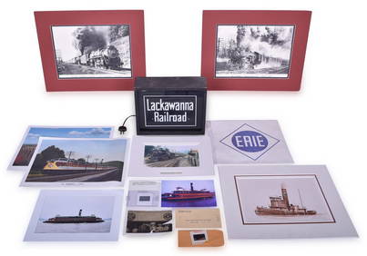
Fourteen Assorted Lackawanna Railroad Items - Light Up Sign, Slides, Photographs, Art Prints, andRail & Road Auctions4.6(165)See Sold PriceMar 07, 2024
Group of New York Central Railroad Paper - Rule Books, Employee Timetables, Stationary, Log Books,Rail & Road Auctions4.6(165)See Sold PriceMar 07, 2024
WEST AFRICA Explorers' routes Senegal Ashanti. Mountains of Kong. SDUK 1857 mapJasper524.5(9.9k)See Sold PriceFeb 28, 2024
WEST AFRICA explorers' routes. Beaufort Gray Park Dochard Caillie. SDUK 1874 mapJasper524.5(9.9k)See Sold PriceFeb 28, 2024
WEST AFRICA I Explorers' routes Senegal Ashanti Ivory Gold Coast. SDUK 1851 mapJasper524.5(9.9k)See Sold PriceFeb 28, 2024
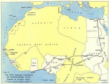
West Africa WW2 Nigeria Sudan Egypt. Takoradi air reinforcement route 1954 mapJasper524.5(9.9k)See Sold PriceFeb 28, 2024
WEST AFRICA showing early explorers' routes & Mountains of Kong. SDUK 1844 mapJasper524.5(9.9k)See Sold PriceFeb 28, 2024
Goode, George Brown 1884 Lot of 4 Natural History & Meteorology MapsAlbion Auctions4.7(341)See Sold PriceMar 01, 2024
Robert de Vaugondy - Map of Canada - Mer de l' Ouest or Sea of the West and a Northwest PassageProverde Auctions4.3(3)See Sold PriceFeb 28, 2024
Hudson River Map & North American Postcards, 45Auctions at Showplace4.6(744)See Sold PriceFeb 13, 2025