Marc Chagall-Limited Edition -Paris Opera Ceiling after ChagallArt Legacy Auctions4.5(215)See Sold PriceFeb 24, 2024
Salvador Dali Pantagruel Limited Edition Lithograph Hand signed and numberedArt Legacy Auctions4.5(215)See Sold PriceFeb 24, 2024
Pablo Picasso Bouquet of Peace Collection Domaine Picasso Limited Edition on paper.Art Legacy Auctions4.5(215)See Sold PriceFeb 24, 2024
A RARE MAXFIELD PARRISH JACK AND THE BEANSTALK PRINTSoulis Auctions4.8(945)See Sold PriceFeb 24, 2024
LARGE MECHANICAL PRINT 'STARS' AFTER MAXFIELD PARRISHSoulis Auctions4.8(945)See Sold PriceFeb 24, 2024
Heinrich Aldegrever, etc. 15 old master prints. 16th-17th centuries. Aldegrever works include "ManTremont Auctions4.6(292)See Sold PriceFeb 25, 2024
SoldMap: Historical War Map, 150 Miles Around RichmondCharles Magnus, New York, 1864; lithograph, printed in red and dark blue, 28 X 20 3/4 in., in protective frameSee Sold Price
Sold1863 Civil War Map, Richmond Area1863 “MANUS’ HISTORICAL WAR MAP: ONE HUNDRED & FIFTY MILES AROUND RICHMOND”, Choice Very Fine. 27.75” x 20.75”, laid down on silk for display and stability, toned along mSee Sold Price
SoldCivil War Map of Richmond[Civil War Map] Grants Campaign War Map Supplement - 25 Miles Around Richmond. Lithographed map. Published by J.H. Bufford at Wastington St., Boston, MA.20" x 15" sheet. Scarce map of the area aroundSee Sold Price
Magnus Map of 150 miles around Richmond, VAMagnus, Charles (1826 - 1900). One Hundred & Fifty Miles Around Richmond. Lithographed Map. New York: Charles Magnus, 1864. 26 ¼" x 30 ¼" sheet. "Eleventh edition 3000 of Magnus' all around map"See Sold Price
MAGNUS MAP - Potomac Army Guide to RichmondMagnus Map. 5 ½" x 8 ¾" Half Dollar Portfolio, which included a "Potomac Army Guide" (150 Miles around Richmond) which when unfolded is 23" x 22 ½". The portfolio originally contained also stationeSee Sold Price
SoldPopular Civil War Era Map of the Capital of theOne Hundred Fifty Miles around Richmond-Battleground of the Wilderness. Julius Bien (1826-1909). Two color lithograph. New York & Washington, c. 1869. 26 x 30 inches, 40 1/4 x 35 1/2 inches framed. ThSee Sold Price
SoldAmerica.- Virginia.- Bacon (George W.) Bacon's New MapAmerica.- Virginia.- Bacon (George W.) Bacon's New Map of the Seat of War in Virginia and Maryland, showing the interesting localities around Richmond, Washington, Baltimore &c., lithograph with someSee Sold Price
G.Woolworth Colton, Map of Washington, 19861Title: G. Woolworth Colton's New County and Railroad Map of the Country 500 Miles Around The City Washington Showing the Seat of War in the East; With List of Forts, Military Stations, Table of PopulaSee Sold Price
Lot of Early Maps & PostersMid to late 19th Century roll up wall maps of US, Nh & Vt, 500 miles around Washington DC, war posters, Liberty Loan, Dawn of American Liberty, 861 National Political Chart, and other, estate of HumphSee Sold Price
SoldLLOYD POCKET MAP OF NEW YORKLLOYD, H. H. 12000 Square Miles Around New York City.New York: H. H. Lloyd, 1866. Hand-colored, two-sheet engraved folding pocket map, the sheets unjoined as issued (the upper sheet measurinSee Sold Price
SoldWAR GAMES MAP OF GETTYSBURGWAR GAMES MAP OF GETTYSBURG Huge 6' x 6' topographical map of the region around and including Gettysburg, ca. 1915, produced by the War Dept. and used by Gen. Robert C. Richardson, Jr. in his trainingSee Sold Price
Sold(CIVIL WAR.) Forbes, W. H. A Complete Map of R(CIVIL WAR.) Forbes, W. H. A Complete Map of Richmond and its Fortifications within a Circle of 12 Miles. Lithographed folding map, 630x470 mm sheet size; minor dampstain in upper left corner, scatterSee Sold Price
MAP OF VALOGNES, FRANCE - DECIMATED ON D-DAYMAP OF VALOGNES, FRANCE - DECIMATED ON D-DAY British War Office 1943 map of Valognes, France, 34 1/2" x 22", showing the ill-fated townalong with the region about fifty miles surrounding. Folds, quiteSee Sold Price
III REICH - MAP OF OSTPREUSSEN & LITHUANIA AROUND 1935III Reich period printed foldable map of the of Ostpreussen & Lithuania. Printed around 1935. Scale: 1:1,000,000.See Sold Price
SoldLOT OF WWII ENGLISH WAR & CATHEDRAL PAMPHLETSLot includes 10 small books and pamphlets detailing English maps, The Blitz, and various historical Cathedrals around England. Also includes small books on Pompeii, Napoleon and other miscellaneous toSee Sold Price
SoldA.E.F. "REPURPOSED" GERMAN MAPA.E.F. 'REPURPOSED' GERMAN MAP Interesting relic from the A.E.F. in France, a 19' x 18' map in black and green showing the region around the German city of Usingen. The map is marked 'Second Edition (See Sold Price
SoldJohnson: Antique Civil War Map of Richmond, 1862Scarce and important 1862 A. J. Johnson map of the vicinity of Richmond, Virginia, during the American Civil War. Full title: “Johnson’s Map of the Vicinity of Richmond, and Peninsular CaSee Sold Price
Sold1862 Hand Colored Engraving Civil War Map of Richmond1862 Hand Colored Engraving Civil War Map of Richmond and Peninsular Areas Hand colored engraving of civil war map of Richmond, it's surrounding counties, and it's closest peninsulas compiled from theSee Sold Price
Johnson: Civil War Map of Richmond, 1862Johnson's 1862 Civil War map of Richmond, Johnson & Ward, 1862 17.75 x 26.5. This is a rare and important 1862 A. J. Johnson map of the vicinity of Richmond, Virginia, during the American Civil War. TSee Sold Price
SoldCivil War map of Richmond, Virginia,hand colored, "Johnson's Map of the Vicinity of Richmond and Peninsular Campaign in Virginia", 1862 by Knowles Hare, several small punctures, light foxing, creases, chips at margins, 18 x 26-3/4"See Sold Price
Sold1862 -Historical War Map- Civil War1862 “Historical War Map” Detailing the Civil War Rebellion 1862, “THE HISTORICAL WAR MAP,” Printed by R.R. Landon, Chicago, IL, Fine. 26” x 24.5” fold-out map, uncSee Sold Price
Sold1862 -Historical War Map- Civil WarMaps1862 “Historical War Map” Detailing the Civil War Rebellion 1862, “THE HISTORICAL WAR MAP,” Printed by R.R. Landon, Chicago, IL, Fine. 26” x 24.5” fold-out map,See Sold Price
Sold1862 -Historical War Map- Civil WarMaps1862 “Historical War Map” Detailing the Civil War Rebellion 1862, “THE HISTORICAL WAR MAP,” Printed by R.R. Landon, Chicago, IL, Fine. 26” x 24.5” fold-out map,See Sold Price
Sold1862 -Historical War Map- Civil WarMaps1862 “Historical War Map” Detailing the Civil War Rebellion 1862, “THE HISTORICAL WAR MAP,” Printed by R.R. Landon, Chicago, IL, Fine. 26” x 24.5” fold-out map,See Sold Price
1875 Rand Avery and Co. Map of Express Companies and Railroads of the USA and CanadaJM Hobby Supply and Railroad Artifact Auctions4.4(126)See Sold PriceFeb 24, 2024
Investors Supplement of the Commercial and Financial Chronicle-September 29, 1888JM Hobby Supply and Railroad Artifact Auctions4.4(126)See Sold PriceFeb 24, 2024
18TH C. ANTIQUE MAP: FRENCH & INDIAN WAR, FRAMEDThomaston Place Auction Galleries4.4(386)See Sold PriceFeb 24, 2024
Jerusalem Map for British Soldiers in Palestine - WW2Levy Auction House4.4(11)See Sold PriceFeb 27, 2024
WAR CHIEF Native American Bronze Statue Sculpture Western Art Marble Base 24" x 23"Weatherham Estate Treasures4(154)See Sold PriceMar 07, 2024
Large lot of assorted prints. 18th-20th century. To include: North American and other maps, CivilTremont Auctions4.6(292)See Sold PriceFeb 25, 2024
Civil War Map, Positions of the Army of the Ohio Front oh Dalton GA Dated 1864 34"L x 24"TSwisher Bros. Auction LLC4.5(237)See Sold PriceFeb 24, 2024
Civil War Map, Positions of the 16th Army Corps Dated 1864 34"L x 24"TSwisher Bros. Auction LLC4.5(237)See Sold PriceFeb 24, 2024
Group of Ten Railroad Photographs, Maps, and Prints - New Jersey, Long Island, and New YorkRail & Road Auctions4.6(165)See Sold PriceMar 07, 2024
Collection of Allied Military Silk Printed Maps, WWII Era and LaterMaterial Culture4.6(759)See Sold PriceFeb 29, 2024
The Complete History of World War II 1948North American Artifact Auctions4.7(175)See Sold PriceApr 20, 2024
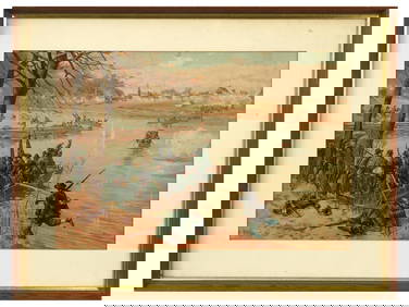
ANTIQUE AMERICAN CIVIL WAR LITHO BY THURE DE THULSTRUPAntique Arena Inc.4.5(834)See Sold PriceFeb 24, 2024
[CIVIL WAR]. Group of Nine Newspapers, Six Confederate and ...Potter & Potter Auctions4.6(538)See Sold PriceMar 07, 2024
[WORLD WAR II – OKINAWA]. Okinawa Shima Western Beaches Top...Potter & Potter Auctions4.6(538)See Sold PriceMar 07, 2024
Mort Kunstler Civil War Print - On to Richmond Custom Gallery FramedMynt Auctions4.6(658)See Sold PriceFeb 24, 2024
[CIVIL WAR]. A group of 10 illustrated covers featuring political cartoons depicting AfricanFreeman's | Hindman4.4(1.6k)See Sold PriceFeb 27, 2024
[CIVIL WAR]. Letter from Adjutant M. Herbert Wood, 23rd USCT, to his sister Mollie concerning herFreeman's | Hindman4.4(1.6k)See Sold PriceFeb 27, 2024
[CIVIL WAR]. Pay Voucher for Private Miles Logan of the 11th Regiment US Colored Troops.Freeman's | Hindman4.4(1.6k)See Sold PriceFeb 27, 2024
Putnam - First Map of the State of Ohio by Rufus PutnamTrillium Antique Prints & Rare Books4.5(28)See Sold PriceFeb 24, 2024
1822 MAP of NORTH & SOUTH AMERICA GEOGRAPHICAL STATISTICAL HISTORICAL antiqueJasper524.5(9.7k)See Sold PriceFeb 27, 2024


![[CIVIL WAR]. Group of Nine Newspapers, Six Confederate and ... (1 of 1)](https://p1.liveauctioneers.com/928/318880/171360938_1_x.jpg?height=282&quality=70&version=1707501302)
![[WORLD WAR II – OKINAWA]. Okinawa Shima Western Beaches Top... (1 of 1)](https://p1.liveauctioneers.com/928/318880/171361141_1_x.jpg?height=282&quality=70&version=1707501302)

![[CIVIL WAR]. A group of 10 illustrated covers featuring political cartoons depicting African (1 of 2)](https://p1.liveauctioneers.com/197/319238/171468107_1_x.jpg?height=282&quality=70&version=1707520367)
![[CIVIL WAR]. Letter from Adjutant M. Herbert Wood, 23rd USCT, to his sister Mollie concerning her (1 of 3)](https://p1.liveauctioneers.com/197/319238/171468124_1_x.jpg?height=282&quality=70&version=1707520367)
![[CIVIL WAR]. Pay Voucher for Private Miles Logan of the 11th Regiment US Colored Troops. (1 of 2)](https://p1.liveauctioneers.com/197/319238/171468127_1_x.jpg?height=282&quality=70&version=1707520367)


