SoldMap, "Abruzzo Citra et Ultra", 17th CenturyMap, "Abruzzo Citra et Ultra",detailed map of the feudal state of Abruzzo, a region in Italy, East of Rome , margins are as is, some soiling, 20.5" by 24"See Sold Price
SoldVintage ABRUZZO CITRA ET ULTRA Framed MapTop right corner reads ABRUZZO CITRA ET ULTRA. Piece is vintage possibly antique. Piece is professionally framed with brown toned wooden frame. 27 inches long 21 inches tall. Framed map, wall art, homSee Sold Price
SoldItaly.- Magini (Giovanni Antonio) Abruzzo Citra, EtItaly.- Magini (Giovanni Antonio) Abruzzo Citra, Et Ultra, regional map of Abruzzo from the the first atlas of Italy produced by an Italian, platemark 380 x 470 mm. (15 x 18 1/2 in), sheet 415 x 540 mSee Sold Price
SoldMap, Virginiae et Floridae, 17th centuryFramed copper engraved map with hand-coloring, ''Virginiae partis australis, et Floridae partis orientalis...,'' by Willem Janszoon Blaeu (Dutch, 1571-1638), after Mercator and Hondius, from Blaeu's 'See Sold Price
SoldAN ANTIQUE FINLAND MAP, "Finmarchiæ et Laplandiæ,"AN ANTIQUE FINLAND MAP, "Finmarchiæ et Laplandiæ," 17TH/18TH CENTURY, hand colored ink engraving on paper, after Frederik de Wit (Dutch 1630-1706) hand numbered in ink 131 U/R, plate: 19 1/2See Sold Price
Large lot (28x) antique German engravings / maps etLarge lot (28x) antique German engravings / maps et cetera. 17th - 18th - 19th - 20th centuries. Size: 12 - 52 cm. In fair / good condition.See Sold Price
SoldLarge lot 28x) of antique German engravings / maps etLarge lot 28x) of antique German engravings / maps et cetera.  17th - 18th - 19th - 20th Century.  Size: 12 - 52 cm.  In fair / good condition.See Sold Price
SoldWillem Janszoon Blaeu (Dutch, 1571-1638) 17C MapWillem Janszoon Blaeu (Dutch, 1571-1638) 17th century map. Nova Belgica et Anglia Nova hand colored engraved map. In good condition, not glued down tape hinge at top. Text on back. Image size 15.3 incSee Sold Price
SoldAN ANTIQUE MAP, "Novissima et Perfectissima Africæ,"AN ANTIQUE MAP, "Novissima et Perfectissima Africæ," CAREL ALLARD, AMSTERDAM, 17TH/18TH CENTURY, exquisitely parcel gilt hand colored engraving on paper, Carel Allard (Dutch 1648 - 1709), cartogrSee Sold Price
Sold17TH CENTURY MAP BY JAN JANSSONA seventeenth century map, Nova et Accurata Poli Arctici, by Jan Jansson. Ht: 29" Wd: 33.5" (framed)See Sold Price
Sold17TH C. HANDCOLORED MAP CONGO AND ANGOLA17th Century handcolored map 'Regna Congo et Angola', 18" x 21", framed 27" x 30". Some damage.See Sold Price
Sold17th Century French School. “Piemonte et Monferrato17th Century French School. “Piemonte et Monferrato [sic]”, Map, Unframed, 16.5” x 20.5”.See Sold Price
SoldFERNANDO ALVARES SECO - Map of 'Portugal deitado'FERNANDO ALVARES SECO - Map of 'Portugal deitado' (Portugal lying down), 17th century PORTVGALLIA et ALGARBIA quae LVSITANIA'. First map of Portugal called 'Portugal lying down'. Amsterdam, Johannes BSee Sold Price
SoldVISSCHER. Portugalliae et Algarbiae RegnaVISSCHER, Nicolaum. Portugalliae et Algarbiae Regna. 17th century. Engraved map, hand-coloured. Framed. 45.8cm x55.7cm (18" x 22")See Sold Price
SoldHenricus Hondius 17th Century Map of Terra Firma etHenricus Hondius 17th Century Map of Terra Firma et Novum Regnum Gratense et Popayan 17.5''x22'' Sheet. Hand colored map of Central American with text on verso. Loose, unframed. Slight overall wear frSee Sold Price
SoldMap, Comitatus Marchia et Ravensberg, BlaeuAn antique map. 17th century. Titled Comitatus Marchia et Ravensberg by Dutch Cartographer, atlas maker and publisher Willem Janszoon Blaeu (1571-1638). A copperplate engraving in full color. The sheeSee Sold Price
SoldMap, Principatus Anhaldinus et MagdeburgensisAn antique map. 17th century, c.1630, Titled Principatus Anhaldinus et Magdeburgensis, Archiepiccopatus, by Dutch Cartographer, atlas maker and publisher Jodocus Hondius (1563-1612). A copperplate engSee Sold Price
SoldMap of "Gastinois et Senonois"Hand colored. William Blaeu, Dutch (17th Century). Approx. 15" H x 19" W unframed, 23" H x 26" W framed. Crease & wear.See Sold Price
Visscher: Antique Map of Visscher Castille Madrid, 1690Title: La Castille Propre ou Vieille, et la Nouvelle; avec l'Estremadure Castillane Dressé sur les Memoires de Rodrigo Mendes Silva, et Autres. Late 17th century Visscher Castille with Madrid townSee Sold Price
SoldJansson Terra di Bari et Basilicata Mid 17th C.[Jansson (Jan)] Terra di Bari et Basilicata, circa mid 17th century. Map of Italy. Map titled "Terra di Bari et Basilicata". Information on the region on verso. Measures 23.25" x 19.5" sheet size. UnfSee Sold Price
SoldJansson Terra di Bari et Basilicata Mid 17th C.[Jansson (Jan)] Terra di Bari et Basilicata, circa mid 17th century. Map of Italy. Map titled "Terra di Bari et Basilicata". Information on the region on verso. Measures 23.25" x 19.5" sheet size. UnfSee Sold Price
Sold17th Century Johannes Blaeu Map17th century 'Montgomeria Comitatus et Comitatus Mervinia' Johannes Blaeu Map from his Atlas Major. This is a splendid map of Merioneth and the duchy of Montgomery. The map is richly embellished withSee Sold Price
Sold17TH C. HAND-COLORED MAP CONGO AND ANGOLA17th Century hand-colored map 'Regna Congo et Angola', 18" x 21", framed 27" x 30". Some damage.See Sold Price
Nicolaes Visscher, Map of the World, 17th Century'Orbis Terrarum Tabula Recens Emendata et in Lucem Edita', 17th century map. Dutch bible double-hemisphere world map with allegorical figure scenes of Europe, Asia, Africa and America in the 4 cornersSee Sold Price
1662 Medieval Royal Advisors Byzantine Alexios III Antioch III Syria James ISchilb Antiquarian Rare Books4.8(422)See Sold PriceMar 10, 2024
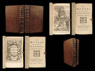
1697 French Ballet & Opera Isaac Benserade Pelee et Thetis Triumph of Love 2vSchilb Antiquarian Rare Books4.8(422)See Sold PriceMar 10, 2024
17th Century Hand Colored Engraved Map of GermanyGlobal Auctions Company4.3(36)See Sold PriceMar 03, 2024
Willem Blaeu, Etc. 17th C. Antiquarian Maps, 2Auctions at Showplace4.6(731)See Sold PriceMar 17, 2024
1629 SPAIN Hispania sive de regis antique Johannes Laet ELZEVIER 17th centuryJasper524.5(9.8k)See Sold PriceFeb 27, 2024
WEST AFRICA Niger/Gambia rivers tribes towns. 'Pays des Negres'. MALLET 1683 mapJasper524.5(9.8k)See Sold PriceFeb 28, 2024
WEST AFRICA. Guinea. Nigeria Ghana Benin Togo Sierra Leone. MALLET 1683 mapJasper524.5(9.8k)See Sold PriceFeb 28, 2024
WEST CENTRAL AFRICA. Congo Angola Gabon Cameroon Sao Tome. MALLET 1683 old mapJasper524.5(9.8k)See Sold PriceFeb 28, 2024
NORTH AFRICA. 'Biledulgerid', a former North African country. MALLET 1683 mapJasper524.5(9.8k)See Sold PriceFeb 28, 2024
WEST AFRICA/MAGHREB Tribes Garamantes Getgulie 'Ancienne Libye'. MALLET 1683 mapJasper524.5(9.8k)See Sold PriceFeb 28, 2024
MALLET. Description de l'Univers. Africa. Volume 3 title page. MALLET 1683Jasper524.5(9.8k)See Sold PriceFeb 28, 2024
NORTH AFRICA. Barbary. Morocco Tunisia Libya Egypt. 'Barbarie'. MALLET 1683 mapJasper524.5(9.8k)See Sold PriceFeb 28, 2024
NORTH AFRICA. Morocco Tunisia Libya. 'Mauritanie'. Malta Melita. MALLET 1683 mapJasper524.5(9.8k)See Sold PriceFeb 28, 2024
NUBIA. 'Nubie'. Nile Valley. Sudan Ethiopia Egypt. MALLET 1683 old antique mapJasper524.5(9.8k)See Sold PriceFeb 28, 2024
SUB-SAHARAN AFRICA. 'Ancienne Ethiopie'. Ancient Ethiopia. MALLET 1683 old mapJasper524.5(9.8k)See Sold PriceFeb 28, 2024
ANTIQUE JUDAICA VELLUM BINDING, ILLUSTRATED IN DE JURE NATURALI ET GENTIUM (1695).NY Elizabeth 4.3(85)See Sold PriceMar 03, 2024
NICOLAS LEMERY'S 1717 PHARMACOPEIA IS AN OLD FRENCH PHARMACOLOGY TREATISE FROM THE 17TH CENTURY.NY Elizabeth 4.3(85)See Sold PriceMar 03, 2024
ANTIQUE 1686 OPERA OMNIA BY JOHN LIGHTFOOT TELLIMA BOUND FOLIO WITH ISRAEL MAPNY Elizabeth 4.3(85)See Sold PriceMar 03, 2024
1634 SAVOY HISTORY & ELZEVIR REPUBLIC ANCIENT SABAUDIA RESPUBLICA ET HISTORIANY Elizabeth 4.3(85)See Sold PriceMar 03, 2024
THE 17TH-CENTURY VELLUM OF SAVOY SABAUDIAE RESPUBLICA ET HISTORIA ANTIQUENY Elizabeth 4.3(85)See Sold PriceMar 03, 2024
CURTIUS RUFUS QUINTUS, SIXTEENTH-CENTURY ELZEVIER HISTORIARUM LIBRI W/ MAP 16.33NY Elizabeth 4.3(85)See Sold PriceMar 03, 2024