SoldMap: A Post Office Directory Map of London for 1910, onMap: A Post Office Directory Map of London for 1910, on linen , scale 4 inches to 1 mile, published by Kelly's Directories Ltd, High Holborn in British Museum binding, having red marbled cover and leaSee Sold Price
SoldA Post Office Directory Map of London for 1910, onA Post Office Directory Map of London for 1910, on linen , scale 4 inches to 1 mile, published by Kelly's Directories Ltd, High Holborn in British Museum binding, having red marbled cover and leatherSee Sold Price
SoldBook: Post Office Directory Map of London for 1918,Book: Post Office Directory Map of London for 1918, Index to the Streets and Places. Published by Kelly's Directories Ltd, London, 1918See Sold Price
Four antique folding maps comprising WH Smith & SonsFour antique folding maps comprising WH Smith & Sons Railway Map of London and Environs, Post Office Directory Map of London 1892, Post Office Directory Map of London 1902 and Bacon's Motoring and CycSee Sold Price
SoldA map of London, Post Office Directory, circa 1893, 25"A map of London, Post Office Directory, circa 1893, 25" x 35.5".See Sold Price
A mixed group of maps,A mixed group of maps, atlases and London related material, including a London underground map, 1926; The Post Office London Directory street plan, 1965; The Official Railway Map of EnglandSee Sold Price
1900 Map of London – printed for the...1900 Map of London – printed for the Post Office Directory, uncoloured, measures 109cmx300cm approx. laid on linen, overall condition appears A/GSee Sold Price
SoldLondon.- Kelly & Co. (publisher) London Drawn &NO RESERVE London.- Kelly & Co. (publisher) London Drawn & Engraved Expressly for the Post Office Directory 1901, large folding lithographed map, 760 x 1080 mm (29 7/8 x 42 1/2 in), dissected and mounSee Sold Price
SoldOne volume ' Beautiful Leaved Plants ' by Lowe andOne volume ' Beautiful Leaved Plants ' by Lowe and Howard, London 1891 with coloured illustrations, two volumes ' Post Office Directory Map of London for 1914 ', two early dictionaries, small leatherSee Sold Price
Post Office Directory Map of Bath c.1900Title: Post Office Directory Map of Bath [cover title] New Map of Bath Drawn & Engraved for the Post Office Bath Directory Author: Lewis, W. Description: Folding map, tipped along one panel into red pSee Sold Price
Post Office Directory Map of Bath c.1900Title: Post Office Directory Map of Bath [cover title] New Map of Bath Drawn & Engraved for the Post Office Bath Directory Author: Lewis, W. Description: Folding map, tipped along one panel into red pSee Sold Price
Sold1874 ATLAS OF WAYNE CO. NY MAPS BY BEERS.1874 ATLAS OF WAYNE CO. NY MAPS BY BEERS. 87 PGS OF HAND COLORED MAPS INCL. BUSIN. DIRECTORY, DISTANCE TABLE, POST OFFICES, POPULATION, ETC. PUBLISHED BY D. G. BEERS & CO, PHIL. 1874. NEW GREEN CLOTHSee Sold Price
Sold1874 ATLAS OF SENECA CO. NY BY POMEROY, MAPS.1874 ATLAS OF SENECA CO. NY BY POMEROY, MAPS. 45 PGS HAND COLORED MAPS INCL. BUSIN. DIRECTORIES, EXPLANATIONS, POPULATION, POST OFFICES, ETC. PUBLISHED BY POMEROY, WHITMAN & CO, PHIL. 1874. ORIG. HARDSee Sold Price
Maps- London & ParisMaps.- London, Drawn & Engraved Expressly for the Post Office 1898, 24 printed paper panels laid onto cloth, 1100 x 750mm., worn at folds and edges, [1898] § Royal Commission on Historical MonumentSee Sold Price
Davies (Benjamin Rees) London. Drawn and EngravedDavies (Benjamin Rees) London. Drawn and Engraved expressly for the Post Office Directory,showing from Highgate down to Brixton Hill, and Plaistow across to East Acton, lithographed map with hSee Sold Price
Two Post Office London Directories.CRITCHETT & WOODS, 13th edition, 1812, small 8vo, later bound; the other for 1823, later half morocco (2)See Sold Price
Antique Map, Environs of LondonFramed antique map, "Environs of London". 19th century. Oval map with four corner cartouches depicting New London Bridge, Triumphal Arch, Hammersmith Suspension Bridge, and New Post Office. The imageSee Sold Price
Geological Map of the Environs of London.Title: Geological Map of the Environs of London. Date: 1884 Cartographer: LETTS Size: 12.5 X 15.5 Mile circles from the General Post Office. Please note that this lot has a confidential reserve. WhenSee Sold Price
SoldOrographical Map of the Environs of London.Publication Date: 1884 Title: Orographical Map of the Environs of London. Cartographer: LETTS Height: 12.5Width: 15.5 Mile circles from the General Post Office. Indicates heights in feet above sea levSee Sold Price
Orographical Map of the Environs of London.Title: Orographical Map of the Environs of London. Publication Date: 1884 Cartographer: LETTS Publisher: LETTS, SON & CO. LIMITED Size: 12.5 X 15.5 Mile circles from the General Post Office. IndicatesSee Sold Price
Geological Map of the Environs of London.Publication Date: 1884 Title: Geological Map of the Environs of London. Cartographer: LETTS Height: 12.5Width: 15.5 Mile circles from the General Post Office. Reserve: $90.00 Shipping: Domestic:See Sold Price
SoldBowles, Carrington 1782 Road Map. Devon, CornwallShowing Dorchester, Axminster, Bridport, Falmouth, Truro etc. Copper Engraved Map Published 1782, London for "Bowles's Post-chaise Companion, Or, Travellers Directory Through England and Wales" by CarSee Sold Price
OVERLAND ROUTE TO INDIA. Ship France Germany Euphrates.TITLE/CONTENT OF MAP: 'Overland Route to India' Vignettes: Post office, London; Gibraltar; Malta; Aden; Bombay; Madras; Suez. The key shows the Mail Steam Packet Route (orange); Marseilles Overland RoSee Sold Price
Hammonds Map of Kentucky and Tennessee Railroads-1910JM Hobby Supply and Railroad Artifact Auctions4.4(127)See Sold PriceFeb 24, 2024
Kenyons Pocket Map and Shippers Guide of Wisconsin-1914JM Hobby Supply and Railroad Artifact Auctions4.4(127)See Sold PriceFeb 24, 2024
A J HANDFORD British Lithographer Rome from Mount Aventi Signed c1910 FramedLuis Porretta Fine Arts4.3(10)See Sold PriceMar 02, 2024
Thirty Pieces of Lackawanna Railroad Ephemera - Chief Engineer Timebook, Map, Public Timetables,Rail & Road Auctions4.6(165)See Sold PriceMar 07, 2024
Rand McNally Railroad Map Cabinet w/ 21 Railroad MapsRail & Road Auctions4.6(165)See Sold PriceMar 08, 2024
Ernest Lawson (American/Canadian, 1873-1939) - Landscape with Red Roofed HutsFreeman's | Hindman4.5(158)See Sold PriceFeb 28, 2024
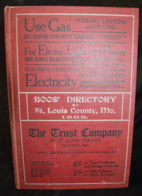
BOOS" Directory of St Louis County 1909North American Artifact Auctions4.7(198)See Sold PriceApr 20, 2024
MILDRED W. PELZER (1890-1985) 1930s IOWA WPA PAINTERSoulis Auctions4.8(953)See Sold PriceFeb 24, 2024
[ARCTIC]. BOWEN, Emanuel. A New & Accurate Map of the North...Potter & Potter Auctions4.6(545)See Sold PriceMar 07, 2024
VINTAGE 1930'S POST OFFICE/BANK COUNTER W/ 2 TRANSACTION WINDOWS 86" X 107" X 11"THOS. CORNELL GALLERIES, LTD./CORNELL AUCTIONS, OBJECTS, AND TRADE4.5(322)See Sold PriceFeb 24, 2024
Moses Soyer Oil on Canvas Painting Signed and datedCollective Hudson4.5(58)See Sold PriceMar 01, 2024
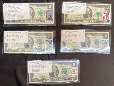
TEN $2 BILLS STAMPED JULY 4, 1976 FROM RICHMOND, VA. 6 ARE CONSECUTIVELY NUMBEREDThe Rug LifeSee Sold PriceMar 07, 2024
Scotland.- Edinburgh.- Under the Patronage of Sir David Wedderburn, Bart. Postmaster-General forForum Auctions4.3(53)See Sold PriceFeb 29, 2024
Scotland.- Sir Walter Scott's Edinburgh.- The Post-Office annual directory, from Whitsunday 1808, toForum Auctions4.3(53)See Sold PriceFeb 29, 2024
Hamms Beer and Cheese Plate Advertising PosterMatthew Bullock Auctioneers4.7(1.8k)See Sold PriceMar 02, 2024
John Senex Map of Louisiana & Mississippi RiverWillow Auction House4.5(289)See Sold PriceMar 14, 2024


![[ARCTIC]. BOWEN, Emanuel. A New & Accurate Map of the North... (1 of 1)](https://p1.liveauctioneers.com/928/318880/171360917_1_x.jpg?height=282&quality=70&version=1707501302)