2 Illuminated Books of Hours LeavesSchmidt's Antiques Inc. Since 19114.8(431)See Sold PriceMar 02, 2024
Illuminated Manuscript Leaf of The CrucifixionSchmidt's Antiques Inc. Since 19114.8(431)See Sold PriceMar 02, 2024
RARE 1930s AUTOGRAPH BOOK FEATURING RUTH & GEHRIGJohn McInnis Auctioneers,LLC4.6(504)See Sold PriceFeb 25, 2024
Timetable, Paper and Ephemera Lot-Eastern USA RailroadsJM Hobby Supply and Railroad Artifact Auctions4.4(126)See Sold PriceFeb 24, 2024
SCARCE 1971 Kim Il Sung Signed Book "ON THE WORK OF THE WOMAN'S UNION"Rbfinearts4.4(575)See Sold PriceFeb 24, 2024
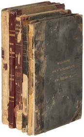
1885 CIVIL WAR 1ed Famous Memoirs US Grant Sheridan Sherman 6v RARE LOT MapsSchilb Antiquarian Rare Books4.8(422)See Sold PriceMar 10, 2024
"WINTER AND SUMMER IN MAINE" 1904 PHOTO ALBUMJohn McInnis Auctioneers,LLC4.6(504)See Sold PriceFeb 25, 2024
1821 THE (3) VOYAGES of CAPT JAMES COOK VOL. I-VIIJohn McInnis Auctioneers,LLC4.6(504)See Sold PriceFeb 24, 2024
[BASEBALL]. [SHEET MUSIC]. KALBFLEISCH, J. H. The Live Oak ...Potter & Potter Auctions4.6(544)See Sold PriceMar 07, 2024
Illuminated Manuscript Leaf of The VisitationSchmidt's Antiques Inc. Since 19114.8(431)See Sold PriceMar 02, 2024
Illuminated Manuscript Leaf of GethsemaneSchmidt's Antiques Inc. Since 19114.8(431)See Sold PriceMar 02, 2024
c1700s RARE Arabic Handwritten Manuscript Middle East Persia Journal ARABIASchilb Antiquarian Rare Books4.8(422)See Sold PriceMar 10, 2024
SoldManuscript Chart of AlaskaCAAMANO, Jacinto (1759-1825?). Manuscript Chart of Bucareli Sound, Alaska (Scale in Nautical Miles). Ink on paper. Spain, c. 1792. 21 1/2 x 17 3/4 inches sheet, 31 x 28 inches framed A RARE EIGHTEENTHSee Sold Price
Caamano Manuscript Map of Alaska[Map, Alaska, Pacific] CAAMANO, Jacinto (1759-1825). Manuscript Chart of Bucareli Sound, Alaska (Scale in Nautical Miles). Ink on paper. Spain, c. 1792. 21 1/2" x 17 3/4" sheet, 31" x 28" framed. A RASee Sold Price
SoldManuscript Chart, World Empires18th century manuscript chart, hand-colored, "An Historical Chart… of the Principal Empires of the World." 34.5" x 14.5". On laid paper and linen-backed.See Sold Price
SoldManuscript Chart of Vancouver, Canada (Nootka)QUIMPER, Manuel (1757-1844). Manuscript Chart of Clayoquot Sound, North of Nootka on the West Coast of Vancouver Island Canada. Ink on paper. Spain, c. 1792. 18 1/4 x 21 inches sheet, 27 1/4 x 30 1/2See Sold Price
SoldManuscript Chart of Neah BayManuscript Chart of Neah Bay. James Allen Scarborough (1805-1852). Manuscript map. c. 1849. 11 1/2 x 19 3/4 inches sheet. Fine manuscript chart of Neah Bay, now part of the Makah Reservation in WashinSee Sold Price
SoldManuscript chart of the Sea of Marmara from thedecorative title cartouche Plan du Grand Canal de Constantinople Fait Sur Le Lieu Par I.A.M.D.C. An 1733 , lower right, detailed coastal outline with 3 compass roses and rhum lines, pen and black inkSee Sold Price
Antique Mongolian Buddhist Manuscript ChartWell preserved Antique Paper Manuscript from Mongolia Plain Wood Covers Lot contains a total 143 leaves. More than 80 of these pages contain detailed charts and more than 6 have star-shaped diagrams.See Sold Price
Original manuscript chart of the Adriatic Sea byFRANZINI, Major Marino Miguel Franconian (1779 - 1861). Carta Reduzida do Golfo Adriatic dedicada a S. A. R. Principe Regente N. S. Pro Marino Miguel Franzini Primro Tenente da Armata Real. ManuscriptSee Sold Price
Manuscript chart of "Isla de los Estados" or "StatenManuscript chart of "Isla de los Estados" or "Staten Island" (Tierra del Fuego). Pen and Ink on paper. C. 1810. 10" x 16" sheet, 12 1/2" x 18 1/2" framed. A Captivating chart of "The End of the Earth"See Sold Price
SoldMinute book for company in Alaskan gold rush.[Manuscript/Alaska Gold Rush] Minute book maintained for the directors of the Alaskan Transportation, Trading, Mining and Manufacturing Company over a 2-month period during Klondike gold rush. IncludeSee Sold Price
SoldScaletta, Carlo-Cesare (1666-1744) Epitome GnomoniScaletta, Carlo-Cesare (1666-1744) Epitome Gnomonica. Bologna: Pisarri, 1702. First edition, quarto, illustrated with text woodcuts and engravings, a full-page, and an added manuscript chart, contempoSee Sold Price
[MAP]. BLAEU, Willem Jansz. Insvlæ Americanæ....Based on Gerritsz’s Foundation Manuscript Chart of the Gulf of Mexico 270. [MAP]. BLAEU, Willem Jansz. InsvlæSee Sold Price
Ms. Chart of a Voyage to San Diego in 1849California Gold Rush Rare Manuscript Chart of a Voyage from Boston to San Diego in 1849 276. [MAP].See Sold Price
SoldAfrican & Chinese slaves rebel on CubaHeading: (Cuba - Slavery) Author: Title: Manuscript chart listing rebellious African and Chinese slaves in Cuba Place Published: Cuba Publisher: Date Published: 1858 Description: <See Sold Price
Manuscript Map of Staten Island / Cape HornManuscript chart of "Isla de los Estados" or "Staten Island" (Tierra del Fuego). Pen and Ink on paper. C. 1810. 10 x 16 inches sheet. A Captivating chart of “The End of the Earth” by an American SSee Sold Price
SoldResident Evil 4 Alice (Milla Jovovich) Map Movie PAlice (Milla Jovovich) two sided, glossy, 'World Aeronautical Chart' Alaska airplane map in Japanese. (approx. 19.5" x 26" unfolded.)See Sold Price
Resident Evil 4 Alice (Milla Jovovich) MapResident Evil Afterlife - Direct from the set of Resident Evil Afterlife, this is Alice (Milla Jovovich) two sided, 'World Aeronautical Chart' Alaska airplane map in Japanese. (approx. 19.5" x 26" unfSee Sold Price
SoldResident Evil Afterlife Alice (Milla Jovovich) MapResident Evil Afterlife - Direct from the set, this is Alice's (Milla Jovovich) two sided, glossy, 'World Aeronautical Chart' Alaska airplane map in Japanese. (approx. 19.5" x 26" unfolded.) (4REA2024See Sold Price
SoldA 19th Century linen-backed Manuscript Sea Chartdrawn by Lieutenant (later Major-General) Richard Wace RA (1842-1920) charting his first voyage to India in 1864 and subsequent return in 1866, pen, ink and blue wash, signed and inscribed with additiSee Sold Price
SoldRand McNally General chart of Alaska comp. by WilliamRand McNally General chart of Alaska comp. by William Ward Duffield 1897. U.S. Coast and Geodetic Survey.Dimensions:52" X 30Inv.147See Sold Price
Vancouver chart of Alaska coastHeading: (Map) Author: Vancouver, George Title: Cote Nord-Ouest de l'Amerique Reconnue par le Cape. Vancouver, Vie Partie... Place Published: Paris Publisher: Date Published: 1799 DescrSee Sold Price
General Chart of AlaskaU.S. C. & G.S., U.S. COAST AND GEODETIC SURVEY, 1895, Wall – 27.25 H x 50.25 W Inches, Two-sheet folding map at the time of the Gold Rush. Size: Wall – 27.25 H x 50.25 W Inches Please note: Item wSee Sold Price
Antique Tibetan Buddhist Astrology Chart ManuscriptWell preserved Antique Paper Manuscript from Mongolia 12 double sided pages plus the 3-disc device. The manuscript is accompanied by 1) a circular diagram drawn one half on each of two folios, which tSee Sold Price
SoldGeneral Chart of Alaska to Accompany Reindeer RepAuthor: U.S. Government Lithographed map. 85.7x126.5 cm. (33¾x49¾"). Large map of Alaska, with insets of the panhandle and the Aleutian islands. The public schools and reindeer stations are shown, aSee Sold Price
Illuminated Manuscript Leaf of The CrucifixionSchmidt's Antiques Inc. Since 19114.8(431)See Sold PriceMar 02, 2024
Illuminated Manuscript Leaf of GethsemaneSchmidt's Antiques Inc. Since 19114.8(431)See Sold PriceMar 02, 2024
Illuminated Manuscript Leaf of The VisitationSchmidt's Antiques Inc. Since 19114.8(431)See Sold PriceMar 02, 2024
2 Illuminated Books of Hours ManuscriptsSchmidt's Antiques Inc. Since 19114.8(431)See Sold PriceMar 02, 2024
c1700s RARE Arabic Handwritten Manuscript Middle East Persia Journal ARABIASchilb Antiquarian Rare Books4.8(422)See Sold PriceMar 10, 2024
Inuit-Made Catholic Altarpiece, Alaska, Early 20th C.Material Culture4.6(769)See Sold PriceFeb 29, 2024
Southern Africa Cape of Good Hope-Madagascar ADMIRALTY sea chart 1935 (1955) mapJasper524.5(9.8k)See Sold PriceFeb 28, 2024
Gulf of Guinea. Ghana Togo Benin Nigeria. ADMIRALTY sea chart 1928 (1954) mapJasper524.5(9.8k)See Sold PriceFeb 28, 2024
South Namibia coast. Walvis Bay-Orange River ADMIRALTY sea chart 1881 (1954) mapJasper524.5(9.8k)See Sold PriceFeb 28, 2024


![[BASEBALL]. [SHEET MUSIC]. KALBFLEISCH, J. H. The Live Oak ... (1 of 5)](https://p1.liveauctioneers.com/928/318880/171361400_1_x.jpg?height=282&quality=70&version=1707501302)


![[MAP]. BLAEU, Willem Jansz. Insvlæ Americanæ.... (1 of 6)](https://p1.liveauctioneers.com/514/20077/6858498_1_x.jpg?height=282&quality=70)