SoldMallet, 3 maps: Asia & China. c.1683[Asia]. 3 engraved maps, fully hand-colored, from Alain Manesson Mallet's ''Description de l'Univers,'' Paris: c.1683. ++ Asie Ancienne. ''De L'Asie. Figure I'' upper margin with #5. French text on veSee Sold Price
Sold3 maps of China & Asia [ca. 1747-85]. Handcol. OL[China/Asia]. 3 engraved maps, each with some outline coloring. Very good condition. ++ Thomas Bowen. A New & Accurate Map Of Asia, Drawn from the most approved Modern Maps & Charts. c.1747. 12 1/8 xSee Sold Price
Sold3 maps incl: De Vaugondy. L'EMPIRE DE LA CHINE.[Asia/China/Britain/Mideast] 3 Maps: ++ Robert de Vaugondy. L’EMPIRE DE LA CHINE Dressee d’Apries les Cartes de l’Atlas Chinois. [No date in cartouche. The same engraving plate was used for theSee Sold Price
Sold3 maps of China/Asia: De Fer, 1705 + Bayly, 1782.[China/Asia]. 3 engraved maps, hand-colored in outline. Very good condition. ++ Nicolas de Fer. La Partie Orientale De L'Asie Ou Se Trouvent Le Grand Empire Des Tartares Chinois Et Celuy Du Iapon. EngSee Sold Price
GREAT TARTARY. 'Grande Tartarie'. Russia China N & Central Asia. MALLET 1683 mapTITLE OF THE MAP: 'Grande Tartarie' (De L'Asie) Tartary (Latin: Tartaria) or Great Tartary (Latin: Tartaria Magna) was a name used by Europeans from the Middle Ages until the twentieth century to desiSee Sold Price
GREAT TARTARY. 'Grande Tartarie'. Russia China N & Central Asia. MALLET 1683 mapTITLE OF THE MAP: 'Grande Tartarie' (De L'Asie) Tartary (Latin: Tartaria) or Great Tartary (Latin: Tartaria Magna) was a name used by Europeans from the Middle Ages until the twentieth century to desiSee Sold Price
SoldJournal of the Proceedings of the Late Embassy...[Asia/China] Henry Ellis. JOURNAL OF THE PROCEEDINGS OF THE LATE EMBASSY TO CHINA… Lon: John Murray, 1817. 1st edition. Abbey, Travel, 526. Tooley 208. 11 plates: 3 maps (1 folding), 1 frontis (stipSee Sold Price
SoldAsia, Russia, China: 4 maps, 1835-1856[Asia]. 4 engraved double-page maps in outline hand-coloring, condition varies. Largest 19 1/4 x 29 1/4, smallest 22 5/8 x 20 1/4 in. First 3 maps listed published Liverpool: George Philip & Son, andSee Sold Price
SoldBartholomew, John 1922 Group of 3 Maps of AsiaSouth Western Asia, Asia - Political, and Father India showing Siam and Indo China. Large Lithograph Maps Published 1922 by The Times, London for "The Times Survey Atlas of the World" Maps by John GeoSee Sold Price
Sold7 Vols: CHINA IN CONVULSION, ...SHANSI, 4 others.[Asia/China] 6 Titles (7 Vols). Mostly 8vo, mostly in orig cloth, 2 modern cloth. ++ Arthur H. Smith. CHINA IN CONVULSION. 2 Vols. Oliphant, Anderson & Ferrier, 1901. 5 maps (3 folding), numerous platSee Sold Price
Sold3 Asian mapsJohnson, Alvin- 3 hand-colored maps, 1862- ''Japan- Nippon, Kiusiu, Sikok, Yesso and the Japanese Kuriles''; ''Asia''; and ''China''- paper has some age toning, minor tears around edges. 14 x 18''See Sold Price
Mallet: Antique Map of Ancient Asia, 1683Title of the Map: 'Asie Ancienne' Ancient Asia. India China Japan Arabia Russia. Date Printed: 1683 Image Size: Approx Overall page size 13 x 21cm approximately (5 x 8 inches); image size 10.5 x 14.5cSee Sold Price
Sold3 maps: Moll, China, Japan; E. Hemisphere; Asia.[Asia]. 3 engraved maps, each hand-colored, in very good condition overall. ++ Herman Moll. The Empire Of China, And Island of Japan, Agreeable to Modern History. c.1727-1739. 9 7/8 x 9 1/2 in. Wide sSee Sold Price
Sold3 maps, China/Asia,Japan, 1809-14[China/Japan/Asia]. 3 engraved double-page maps from ''Pinkerton's Modern Atlas'' drawn by I. Hubert and engraved by Neele. 22 x 19 7/8 in. to 20 x 27 3/4 in. Original outline color to Japan and Asia,See Sold Price
1899 Rand McNally Map of Asia from China, Japan to Indonesia -- China, French Indo-China, Siam,Title: 1899 Rand McNally Map of Asia from China, Japan to Indonesia -- China, French Indo-China, Siam, Malaysia & Korea Cartographer: Rand McNally Year/Place: 1899, Chicago Dimensions: 18.6 x 12.3 in.See Sold Price
Mallet: Antique Map of Ancient Asia, 1683Title/Content of Map: 'Asie Ancienne' India China Japan Arabia Russia. Date Printed: 1683 Image Size: Approx Overall page size 13 x 21cm approximately (5 x 8 inches); image size 10.5 x 14.5cm approximSee Sold Price
Mallet: Antique Map of Ancient Asia, 1683TITLE OF THE MAP: 'Asie Ancienne' India China Japan Arabia Russia. DATE PRINTED: 1683 IMAGE SIZE: Approx Overall page size 13 x 21cm approximately (5 x 8 inches); image size 10.5 x 14.5cm approximatelSee Sold Price
ASIA. 'Asie Moderne'. India China Japan Arabia Persia (Iran). MALLET 1683 mapTITLE OF THE MAP: 'Asie Moderne' (De L'Asie) DATE PRINTED: 1683 IMAGE SIZE: Approx Overall page size 13 x 21cm approximately (5 x 8 inches); image size 10.5 x 14.5cm approximately (4 x 5.5 inches) TYPSee Sold Price
ASIA. 'Asie Moderne'. India China Japan Arabia Persia (Iran). MALLET 1683 mapTITLE OF THE MAP: 'Asie Moderne' (De L'Asie) DATE PRINTED: 1683 IMAGE SIZE: Approx Overall page size 13 x 21cm approximately (5 x 8 inches); image size 10.5 x 14.5cm approximately (4 x 5.5 inches) TYPSee Sold Price
ASIA. 'Asie Moderne'. India China Japan Arabia Persia (Iran). MALLET 1683 mapTITLE OF THE MAP: 'Asie Moderne' (De L'Asie) DATE PRINTED: 1683 IMAGE SIZE: Approx Overall page size 13 x 21cm approximately (5 x 8 inches); image size 10.5 x 14.5cm approximately (4 x 5.5 inches) TYPSee Sold Price
SoldRambles in Eastern Asia, Including China and ManiAuthor: Ball. B[enjamin] L. 417 + [3] ad pp. Woodcut map. 7½x4½, original read blindstamped cloth, spine lettered in gilt. First Edition. Scarce work of some interest, written in journal form with lSee Sold Price
Sold3 maps: China/Asia, [c1640] - [1785].[Asia/Russia]. 3 engraved maps, uncolored, two in very good condition. ++ China Veteribus Sinarum Regio Nunc Incolis Tame Dicta. c.1640. 10 1/2 x 13 1/4 in. Mild worming top of center fold, light foxiSee Sold Price
EARLY FRENCH MAP OF THE NORTH PACIFICEarly hand-colored map of the North Pacific, 15 1/4" x 11 3/4", printed in French circa 1779-1780 by "Dupuis". The map depicts the coast of Asia from southern China to the Kamchatka Peninsula, the JapSee Sold Price
Sold3 Engraved maps3 Engraved maps. 1). Europe, Showing its Political Divisions. 2). Asia, Showing It's Political Divisions and also the various /route of Travel between London & India, China and Japan. 3). Oregon, WasiSee Sold Price
Chatelain - 3 Maps of the British Isles (England, Ireland, Scotland)Trillium Antique Prints & Rare Books4.5(32)See Sold PriceFeb 24, 2024
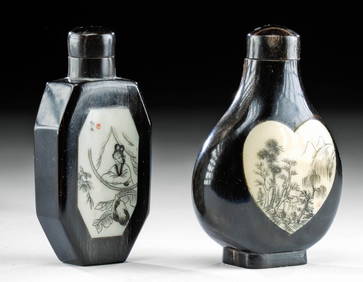
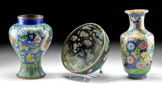
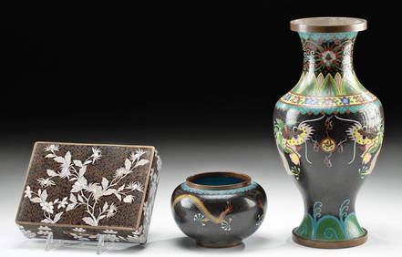
Chinese Enameled Copper Snuff Box w/ Ivory FiguresArtemis Fine Arts4.8(1.4k)See Sold PriceFeb 26, 2024
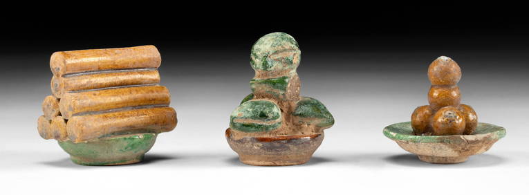
Chinese Ming Glazed Mingqi / Food Offerings, 3pcsArtemis Fine Arts4.8(1.4k)See Sold PriceFeb 26, 2024
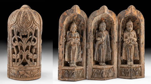
19th C. Chinese Folding Wood Travel Altar, 3 GuanyinArtemis Fine Arts4.8(1.4k)See Sold PriceFeb 26, 2024
Artifact Bundle - Roman, Chinese, Sumerian, LuristanArtemis Fine Arts4.8(1.4k)See Sold PriceFeb 26, 2024
Chinese Ming / Qing Blue-on-White Porcelain VesselsArtemis Fine Arts4.8(1.4k)See Sold PriceFeb 26, 2024
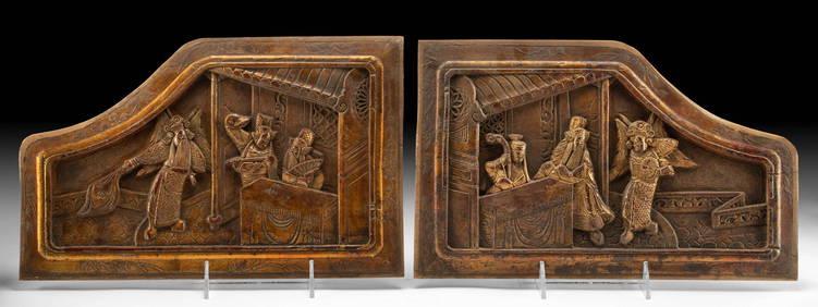
19th C. Chinese Qing Wood Relief Panels for Martial BedArtemis Fine Arts4.8(1.4k)See Sold PriceFeb 26, 2024
Chinese Han Dynasty Terracotta Mingqi Figures (pr)Artemis Fine Arts4.8(1.4k)See Sold PriceMar 01, 2024
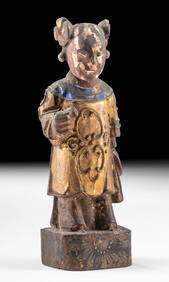
19th C. Chinese Gilded Figure (for Shrine / Altar NicheArtemis Fine Arts4.8(1.4k)See Sold PriceMar 01, 2024


![3 maps of China & Asia [ca. 1747-85]. Handcol. OL (1 of 3)](https://p1.liveauctioneers.com/179/15522/5074078_1_x.jpg?height=282&quality=70&version=1206672512)


![3 maps: China/Asia, [c1640] - [1785]. (1 of 3)](https://p1.liveauctioneers.com/179/15522/5073998_1_x.jpg?height=282&quality=70&version=1206672512)