Marc Chagall-Limited Edition -Paris Opera Ceiling after ChagallArt Legacy Auctions4.5(219)See Sold PriceFeb 24, 2024
Salvador Dali Pantagruel Limited Edition Lithograph Hand signed and numberedArt Legacy Auctions4.5(219)See Sold PriceFeb 24, 2024
Pablo Picasso Bouquet of Peace Collection Domaine Picasso Limited Edition on paper.Art Legacy Auctions4.5(219)See Sold PriceFeb 24, 2024
A RARE MAXFIELD PARRISH JACK AND THE BEANSTALK PRINTSoulis Auctions4.8(953)See Sold PriceFeb 24, 2024
LARGE MECHANICAL PRINT 'STARS' AFTER MAXFIELD PARRISHSoulis Auctions4.8(953)See Sold PriceFeb 24, 2024
Heinrich Aldegrever, etc. 15 old master prints. 16th-17th centuries. Aldegrever works include "ManTremont Auctions4.6(294)See Sold PriceFeb 25, 2024
SoldMaine Coast ( U.S. Coast Survey), Litho, C.1864Artist: A.D. Bache, Title: U.S. Coast Survey - Sketch A - Maine Coast, Pub: U.S. Coast Survey, Date: C.1864, Medium: Lithograph, Paper size: 23 x 30, Retail: $675, Condition: Good condition, with foldSee Sold Price
SoldMAINE COAST ( U.S. COAST SURVEY), LITHO, C.1864Artist: A.D. Bache, Title: U.S. Coast Survey - Sketch A - Maine Coast, Pub: U.S. Coast Survey, Date: C.1864, Medium: Lithograph, Paper size: 23 x 30, Retail: $675, Condition: Good condition, with foldSee Sold Price
Sold1853 U.S. Coast Survey R.I. to Maine MapLarge map 22x34", as viewed, matted and framed larger of the U.S. coast line between R.I. and Maine as detailed in Survey A, sketch 1. On paper so some aging along the fold lines. Very detailed.See Sold Price
SoldA.D. Bache U.S. Coast Survey Charts East CoastA.D. Bache: Preliminary Coastal Chart N. 8, Sequin Island to Kennebunkport, Maine 1859. Measures 38” X 22”. Paper size 40" x 24 1/2". Used Condition, creases, burn. electrotype have some sSee Sold Price
Six charts from the U.S. Coasts SurveyTitle: Six charts from the U.S. Coasts Survey Author: U.S. Coast Survey Description: Includes: Chart of Portland Harbor, Maine. 56x52 cm. 1855. * Sketch A. Showing the Progress of the Survey in SectioSee Sold Price
Six charts from the U.S. Coasts SurveyTitle: Six charts from the U.S. Coasts Survey Author: U.S. Coast Survey Description: Includes: Chart of Portland Harbor, Maine. 56x52 cm. 1855. * Sketch A. Showing the Progress of the Survey in SectioSee Sold Price
Six charts from the U.S. Coasts SurveyTitle: Six charts from the U.S. Coasts Survey Author: U.S. Coast Survey Description: Includes: Chart of Portland Harbor, Maine. 56x52 cm. 1855. * Sketch A. Showing the Progress of the Survey in SectioSee Sold Price
Sold19th C. Chart of "Penobscot Bay to Kennebunk19th Century chart of Maine "Penobscot Bay to Kennebunk Entrance" coasts chart #105 by the U.S. Coast survey, 46 x 35 1/2. Good condition.See Sold Price
Sold19th century chart “Wells to Cape Ann”Original US Coast and Geodetic survey chart from 1899 showing the New England coast from Cape Ann in Gloucester Mass up to Wells Maine. Identified as chart no 108. Nicely framed. 43” x 36”See Sold Price
SoldKennebunkport, ME, 1872 mapKennebunkport Sea Shore Company Lands, from U. S. Coast Survey, Topography Coast of Maine, Vicinity of Kennebunkport, surveyed in 1869-70," 1872, J. Mayer & Co., Litho, Boston, 21"H x 35"W plus marginSee Sold Price
Booth Bay Harbor MaineTitle/Content of Map: Booth Bay Harbor Maine Cartographer: WEST, P. C. F./F. W. DORR Date: 1864 Publisher: U.S.COAST SURVEY Size: 19Height - 15.5Width "from a trigonometrical survey..." Detailed coastSee Sold Price
Greenwich CT Coast, US Coast Survey 1849Title: Harbors Of Captain's Island East And Captain's Island West (Harbors of Refuge) Subject: Greenwich, CT Coast Maker: US Coast Survey Date: 1849, US Coast Survey: Washington DC Size: 14.4 x 17.4 iSee Sold Price
SoldAtlantic Coast, U.S. Coast Survey, c. 1846Domestic: Free Shipping Map Title: Chart Showing the Contour of the Atlantic coast..., U.S. Coast Survey Date: c. 1846 Medium: Steeplate engraved map. Size: 28.75 x 35.5 inches. Showing the Atlantic cSee Sold Price
SoldWALL MAP OF THE STATE OF MAINE.Circa 1862, Portland, Maine. J. Chace, Jr. & Co. Publishers. U.S. Coast Survey Table by H.F. Walling. A large map showing the state of Maine. The towns and counties, maps of some small towns tipped inSee Sold Price
SoldUS Coast Survey Map of the Louisiana CoastAntique US Coast Survey Map of the Louisiana Coast , "U.S. Coast Survey, A.D. Bache, Superintendent", 1855, lithograph, with later hand-coloring, showing Vermillion Bay, LA to Mobile Bay, AL, sight 15See Sold Price
St. George's River & Muscle Ridge Channel MaineU.S. Coast Survey, Bache, A.D., 1873, Wall – 37.80 H x 26.25 W Inches, Details Monhegan I. to Monroe I. Shows soundings, islands, light houses, also roads & fields near South Thomaston. Light browniSee Sold Price
SoldFRAMED 1868 CHART FOX ISLANDS THOROUGHFARE, MAINEU.S. Coast Survey, Benjamin Peirce Superintendent, 1868, Scale 20,000, in black and gold frame, matted and glazed, OS: 28 1/2" x 40", SS: 22 3/4" x 34". Damaged on left edge.See Sold Price
SoldMap of Gulf Coast for US Coast SurveyMap of Gulf Coast for US Coast Survey , "U.S. Coast Survey....Section No. 8, 1845-1851", lithograph, with later hand-coloring, sight 15 1/2 in. x 22 3/4 in., framed Provenance: Estate of Julia Evans RSee Sold Price
SoldU.S. Coast Survey Map of South Farallon Island and San(lot of 2) Alexander Dallas Bache (American, 1806 - 1867), South Farallon Island, 1855, and San Clemente Island, 1856, U.S. Coast Survey hand-colored copper engraved maps, overalls (with frames): 18"hSee Sold Price
SoldCivil War Era U.S. Coast Survey, 1859Civil War Era U.S. Coast Survey, 1859: (1) "Report of the Superintendent of the Coast Survey showing The Progress of the Survey during The Year 1859" (Washington: Thomas H. Ford, Printer, 1860), 370 pSee Sold Price
SoldU.S. COAST SURVEY PRINTED MAPSU.S. COAST SURVEY PRINTED MAPS, H 7"-9 1/2" W 7 1/2"-16":Including map of Sketch E. No. 2, "Showing the Progress of the Survey in the Vicinity of Savannah, Georgia, 1850-1852", measuring H. 8 1/2" x 8See Sold Price
Sold2 U.S. Coast Survey Maps, Catalina Harbor & West CoastLot of two U.S. Coast Survey Maps to include: Catalina Harbor, "1852" and Reconnaissance of the Western Coast of the United States, middle sheet, from San Francisco to the Umpquah River, "1854," frameSee Sold Price
SoldAN ANTIQUE SURVEY MAP, "U.S. Coast Survey: GalvestonAN ANTIQUE SURVEY MAP, "U.S. Coast Survey: Galveston Entrance," CIRCA 1867, lithograph on paper, No. 13, a United States Coast Survey, Benjamin Pierce, Superintendent, "The Triangulation was executedSee Sold Price
SoldGrp: 2 Maps of San Francisco U.S. Coast SurveyTwo maps of San Francisco, California, by the U.S. Coast Survey, featuring a high level of topographical and hydrographical detail. SKU: 03479See Sold Price
Boston and Maine RR A Trip from Ocean to Ocean Book-1901JM Hobby Supply and Railroad Artifact Auctions4.4(126)See Sold PriceFeb 24, 2024
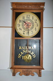
Atlantic Coast Line RR Station ClockJM Hobby Supply and Railroad Artifact Auctions4.4(126)See Sold PriceFeb 24, 2024
Eight Working HO Scale Diesel Locomotives-Seaboard Coast Line RR/Army TrainJM Hobby Supply and Railroad Artifact Auctions4.4(126)See Sold PriceFeb 25, 2024
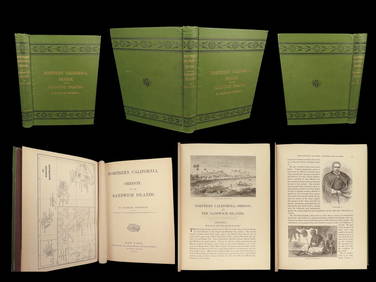
1874 HAWAII 1ed Northern California Oregon Pacific Island Travel Puget RedwoodsSchilb Antiquarian Rare Books4.8(422)See Sold PriceMar 10, 2024
BOTH TITLE PAGES OF COLLINS" COASTAL SURVEY, 1776, IN MATCHING FRAMESThomaston Place Auction Galleries4.4(389)See Sold PriceFeb 24, 2024
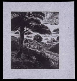
CARROLL THAYER BERRY (ME, 1886-1978)Thomaston Place Auction Galleries4.4(389)See Sold PriceFeb 25, 2024
Vintage Puck Magazine U.S. Senate Political LithoThe Benefit Shop Foundation Inc.4.3(2.9k)See Sold PriceFeb 28, 2024
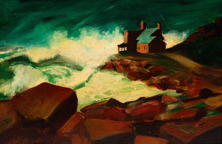
William A. Hill (1886 -1969) Antique American Impressionist Maine Coast Original Oil PaintingCurated Gallery Auctions4.6(128)See Sold PriceFeb 25, 2024
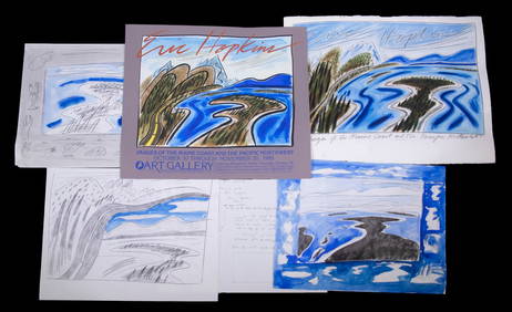
Alton S. Tobey, Toward the Arctic SunLotus International Auctions, LLC4.6(153)See Sold PriceMar 03, 2024
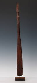
Food Spatula, Geelvink Bay, Northwest Coast Papua New Guinea, Early 20th C. or OlderMaterial Culture4.6(769)See Sold PriceFeb 29, 2024
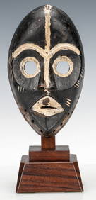
African Gunye Ge Dan Mask, Ivory Coast, Early-Mid 20th C.Material Culture4.6(769)See Sold PriceFeb 29, 2024
African Guro Standing Female Figure, Ivory Coast, Mid 20th C.Material Culture4.6(769)See Sold PriceFeb 29, 2024
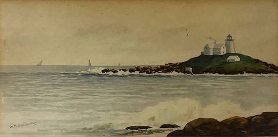
AFTER CHARLES HERBERT WOODBURY (1864-1940) "MAINE COAST".Amelia Jeffers, Auctioneers & Appraisers4.5(116)See Sold PriceMar 07, 2024
1852 CHART SHOWING POSITIONS of DAVIS'S SOUTH SHOAL & OTHER DANGERS antiqueJasper524.5(9.8k)See Sold PriceFeb 27, 2024
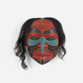
Don Lelooska, Untitled (Northwest Coast mask)Toomey & Co. Auctioneers4.7(391)See Sold PriceFeb 29, 2024
Group of 2 Georg Fischer 207 Tin Litho Wind-Up MotorcyclesMatthew Bullock Auctioneers4.7(1.8k)See Sold PriceMar 02, 2024