SoldLarge Lot of 18th and 19th c. Maps of EuropeGroup of 29 18th and 19th c. maps of Europe including maps of Antwerp, Brussels, Berlin, England, Scandinavia, Amsterdam, Dublin, the Plymouth Sound, Vienna, Venice, Cunersdorf, Prague, Dresden, ParisSee Sold Price
SoldTwo 18th C. Maps & Two 18th C. EngravingsLot consists of three 18th century engravings--1st item: Mid 18th century map titled "A New Map of Carolina by Robert Morden"; page taken from a book or publication "A Description of Carolina"; map siSee Sold Price
SoldSamuel Holland / H.D. Tyler, map early ManhattanSamuel Holland / H.D. Tyler, map early Manhattan, Samuel Holland / H.D. Tyler (British, 18th c.), "Map of the Original Grants of village lots from the Dutch West India Company to the inhabitants of NeSee Sold Price
Sold3 18th C. Engraved Maps of FranceLot of three engraved maps of France, 20 1/4"h x 24 1/2"w (largest). Creases and toning.See Sold Price
SoldH/P EARLY MANUSCRIPT MAP/ACTUAL SURVEY NYH/P EARLY MANUSCRIPT MAP/ACTUAL SURVEY NEW YORK INCL. INDIAN TERRITORY/SECTION LOT/PLOT, 18TH C. 19" X 34"See Sold Price
Sold18th C Engraving Zucchi w/ Map England18th Century engraving by Zucchi showing a map of England and Scotland from the German Sea. Fine ,measures 7.25 x 11". Please note that this lot has a confidential reserve. When you leave a bid in advSee Sold Price
Antique European Map Spain & Portugal, 18th CAntique European Map Spain & Portugal. Matted dimensions ca 30x24 plate 27. 18th century Please note that this lot has a confidential reserve. When you leave a bid in advance of the auction, submit yoSee Sold Price
Soldlot of 18th and early 19th c. leather bound booksincl. 1784 Belkap's History of NH in 3 vols. w/fold out map (as is), 1833 Burlington printed Zaddock Thompson's History of VT, partial 1733 series of The Spectator London, American Antiquities, etc. 1See Sold Price
Sold(3) NEWBURGH, N.Y. INDENTURE 1729, LOT AND PARCELLOT (2) INCL. RARE NEWBURGH, N.Y. INDENTURE (NEW BURROUGH) 1729, LOT AND PARCEL MAP "THE MINISTER'S LAND" A MAP OF NEWBURGH LOTS LYING IN THE GERMEN PASS, 18TH C., ALSO INCL. IS A HAND COLOR MAP OF THSee Sold Price
Sold(3) ANTIQUE MAPS, BRAZIL, PERU, AMAZON, 18TH C.(lot of 3) Antique maps, including: (1) "Carte de la Terre Ferme du Perou, du Bresil, et du Pays des Amazones," (Peru, Brazil, Amazon), c.1725, Coven & Mortiers Publishers, based on the cartography ofSee Sold Price
Sold(3) ANTIQUE MAPS, SPAIN, PORTUGAL, SAXONY, 18TH C.(lot of 3) Antique maps, including: (1) "Saxonie Inferioris Circulus...," c.1730, Georg Matthaus Seutter (German, 1678-1757), hand colored, approx 20.5"h, 23.75"w; (1) "La Catalogna Li Regni Di AragonSee Sold Price
SoldLot of 16- 16th, 17th and 18th C BooksLot of 16- 16th, 17th and 18th C Books: Les Commentaires de Cesar, 1652 with map; Cleopatre, 1st part 1648; Historia delle Guerre, 1638; Roma Antica e Moderna; Lettres Politiques et Moralles de PlineSee Sold Price
SoldLOT MANUSCRIPT MAPS/SURVEYS, STATE OF NYLOT ASSORTED MANUSCRIPT MAPS/SURVEYS W/ SECTION LOT/PLOT, STATE OF NEW YORK, 18TH C., LARGEST 18" X 19"See Sold Price
Sold2 German Maps and 4 French books, 18th c.Lot of 6 European books & documents. 1ST ITEM: Two German maps, one depicting the Kingdom of Hanover and the other depicting a German village with central school and church. Both retailed by Franz LaFSee Sold Price
SoldHand-Colored Copper Engraved Antique Maps(lot of 2) Matthäus Seutter III (German, 1678-1757), Roterodami Delineatio Ichnographica et Scenographica opera, and Heredibus Homanni (18th c.), Haga Comitum (Prospect von Graven Haag), hand-coloredSee Sold Price
Sold18th/19th C. Maps and Colored Engravings(4)18th and 19th century maps and colored engravings. Group of four. Measure 13.375 in. - 18.5 in. x 9.625 in. - 11.25 in. F-G/G to G-VG. Unframed, loose and not mounted or glued down. If lot is absent oSee Sold Price
Sold5 RARE H/C MANUSCRIPT/ACTUAL SURVEY MAP STOCKPORT NYLOT (5) RARE H/C MANUSCRIPT ACTUAL SURVEY MAP STOCKPORT NY W/ SECTION, BLOCK & LOT NAMED INCL. DELAWARE RIVER; ROAD TO FORT PENN, 18TH C. 19" X 24" W/ MANUSCRIPT LETTER TO SAMUEL PRESTON AUTHORIZING ASee Sold Price
SoldFramed 18th century French maps, Abraham Ortelius(lot of 2) Framed 18th century French maps, including an Abraham Ortelius (1528-1598), Poictou / Pictonum Vicinarum que Regionum Fidiss Descripto., Antwerp, C. Plantin, 1579, hand colored map of the PSee Sold Price
Sold(2) 18TH CENTURY FRENCH & GERMAN MAPS(lot of 2) Maps; (1) framed map from the "Atlas Universal" by Gilles Robert de Vaugondy and son (France, c.1723-1786), entitled "Gouvernement General de L'Isle de France, divise par Pays, Par le Sr. RSee Sold Price
Sold18th C. Map of LouisianaAn 18th C. hand-colored engraved map by Emanuel Bowen, titled "A New and Accurate Map of Louisiana with Part of Florida and Canada, and the Adjacent Countries", Plate 59. Likely from the "Complete AtlSee Sold Price
Sold2-Pc Lot 18th C. Carved Wooden Santos 23 1/2"H, 6" x2-Pc Lot 18th C. Carved Wooden Santos 23 1/2"H, 6" x 8" / 17" x 9" x 6"See Sold Price
SoldFRAMED RARE 18TH C. MAP OF CORFU BY HOMANNSPlan de la Place de Corfu avec ses Environs Assiegee Par les Infideles, tranchee ouverte le 25me Juillet jusqu'au 22 me d'Aout, Iour de la Fuite des Ottomans". Homann, J. B. Circa 1740. Hand colored cSee Sold Price
Sold18th C Map Ancient World JerusalemEngraved plate showing maps of ancient world including inset of Judea and Samaria and one of Jerusalem. Early 18th century.Very Good, trimmed to plate lines, measures 7 x 5.5". Reserve: $20.00 ShippinSee Sold Price
Sold18TH C MAP, NORTH AMERICA, UNITED STATES & MEXICOJohann Baptist Homann (German, 1664-1724). "Regni Mexicani seu Novae Hispaniae" - circa 1725, engraving with hand coloring. Approx. 20.75" x 24" (sheet) Item from the Estate of Forest "Tag" Hunter, AtSee Sold Price
EARLY 18TH C. MAP OF ITALY, FRAMEDThomaston Place Auction Galleries4.4(393)See Sold PriceFeb 24, 2024
18TH C. ANTIQUE MAP: FRENCH & INDIAN WAR, FRAMEDThomaston Place Auction Galleries4.4(393)See Sold PriceFeb 24, 2024
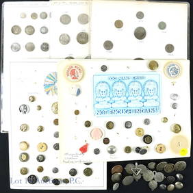
CHINESE KANGXI PERIOD PORCELAIN SAUCERSThomaston Place Auction Galleries4.4(393)See Sold PriceFeb 24, 2024
18th C. Chinese Export Porcelain Posset PotEpic Auctions and Estate Sales4.6(210)See Sold PriceMar 02, 2024
Three 18th C. Chinese Export Porcelain CupsEpic Auctions and Estate Sales4.6(210)See Sold PriceMar 02, 2024
Baker 18th C. Style 3 Drawer Bombe ChestEpic Auctions and Estate Sales4.6(210)See Sold PriceMar 02, 2024
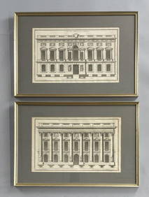
2 Framed 18th C. Parisian Architectural PrintsEpic Auctions and Estate Sales4.6(210)See Sold PriceMar 02, 2024
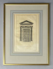
18th C. Etching "A Door of the Composite Order"Epic Auctions and Estate Sales4.6(210)See Sold PriceMar 02, 2024
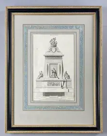
18th C. French Neoclassical Tomb Print IEpic Auctions and Estate Sales4.6(210)See Sold PriceMar 02, 2024
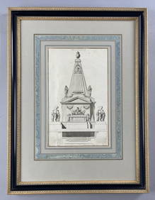
18th C. French Neoclassical Tomb PrintEpic Auctions and Estate Sales4.6(210)See Sold PriceMar 02, 2024
LOT OF 9 ANTOINE DE MARCENAY ETCHINGS 18th C.Marnie Collection Auction4.5(70)See Sold PriceMar 10, 2024
Two (2) Antique 18th C. Copper Engraved Framed Maps - America & EuropeMagnusson Art Group4.5(53)See Sold PriceMar 14, 2024
Map: An 18thC engraved and hand coloured map of Buckinghamshire after Robert Morden. Approx. 8 1/4"Claydon Auctioneers Ltd4.3(125)See Sold PriceFeb 26, 2024
Map: An 18thC engraved and hand coloured map of Northamptonshire, with description ofClaydon Auctioneers Ltd4.3(125)See Sold PriceFeb 26, 2024
Map: An 18thC engraved and hand coloured map of North America and South America, titled DeClaydon Auctioneers Ltd4.3(125)See Sold PriceFeb 26, 2024
Map: An 18thC engraved map of Bedfordshire titled An Accurate Map of the County of Bedford DividedClaydon Auctioneers Ltd4.3(125)See Sold PriceFeb 26, 2024
Map: An 18thC engraved map titled A New and Improved Map of Oxfordshire.. after Thomas Kitchin.Claydon Auctioneers Ltd4.3(125)See Sold PriceFeb 26, 2024
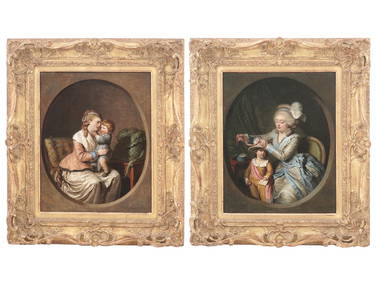
18TH C FRENCH PAINTINGS BY PIERRE ALEXANDRE WILLEAntique Arena Inc.4.5(878)See Sold PriceMar 09, 2024