SoldSamuel Holland / H.D. Tyler, map early ManhattanSamuel Holland / H.D. Tyler, map early Manhattan, Samuel Holland / H.D. Tyler (British, 18th c.), "Map of the Original Grants of village lots from the Dutch West India Company to the inhabitants of NeSee Sold Price
(5) EARLY FRAMED BRITISH MAPS & COAT OF ARMS(lot of 5) Framed English color maps, originally in a bound book, likely 18th c., showing the coat of arms and regions of Rippon, Scarborough, Pontefract, the Bishoprick of Durham and Stamford, set inSee Sold Price
Sold18th C. British Map - Triangular Trade - Thomas BowenThomas Bowen. A New & Accurate Chart of the Western or Atlantic Ocean Drawn from the Most Approved Modern Maps Etc. By Thos. Bowen 1788. Engraved for Thomas Bankes's New System of Geography. PublishedSee Sold Price
Sold18TH C. BRITISH MAP OF SUFFOLK COUNTYA Map of Suffolk County by J. OWEN & E. BOWEN 1753, with "The Road from Ipswich to Norwich" above, hand colored copperplate engraving, in black and gold stick frame, French-lined mat, glazed, OS: 11"See Sold Price
SoldHENRY POPPLE 18th C. MAP: BRITISH EMPIRE IN AMERICAA Map of the British Empire in America with the French, Spanish and Hollandish Settlements', by Henry Popple, Covens & Mortier: Two sheets joined at the center, the left hand sheet includes an ornateSee Sold Price
SoldLarge Lot of 18th and 19th c. Maps of EuropeGroup of 29 18th and 19th c. maps of Europe including maps of Antwerp, Brussels, Berlin, England, Scandinavia, Amsterdam, Dublin, the Plymouth Sound, Vienna, Venice, Cunersdorf, Prague, Dresden, ParisSee Sold Price
SoldAssorted 18th/19th C. American/European Books[1 box] Lot, assorted 18th / 19th C. American and British law, geography, religious, etc. titles.See Sold Price
SoldAssorted 18th/19th C. American/European Books[1 box] Lot, assorted 18th / 19th C. American and British religious, history, etc. titles.See Sold Price
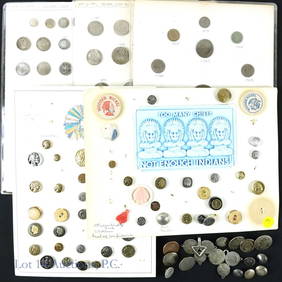
LOT OF 5 EARLY COPPER CENTSLOT OF 5 EARLY COPPER CENTS Lot of early 18th C. copper coinage including four British half cents and one colonial shield cent. Weight: 44.2 gramsSee Sold Price
Sold1755 FRENCH MAP OF BRITISH COLONIESSr. Robert de Vaugondy (18th c., France) 18th c map of the British Colonies with inset of the South Carolina Coast. Map by Sr. Robert de Vaugondy. Hand-Colored, on laid paper in two parts. 20.5" h x 2See Sold Price
SoldSet of 18th C. British MeasuresSet of 18th century British measures, lot of five, heavily hallmarked. Provenance: MA estate.See Sold Price
SoldTwo 18th C. Maps & Two 18th C. EngravingsLot consists of three 18th century engravings--1st item: Mid 18th century map titled "A New Map of Carolina by Robert Morden"; page taken from a book or publication "A Description of Carolina"; map siSee Sold Price
SoldFrench 18th C. Map of the WorldGROUP LOT OF 6 MAPS WITH FINE ORIGINAL COLOR Louis Brion de la Tour (c. 1743 – 1803) from Louis C. Desnos' Atlas General Engraved maps with hand color in full Paris, 1779 (1783) each approximately 2See Sold Price
Sold18th C. Kitchin Map Georgia & South CarolinaHand-colored Revolutionary War-era British map by Thomas Kitchin (also Kitchen) "A Map of such parts of Georgia and South Carolina as tend to Illustrate the Progress and Operations of the British ArmySee Sold Price
Sold18THC. LOTTER'S MAP OF THE BRITISH COLONIES FOR THEFOR THE FRENCH MARKET (24" X 19 1/2" PLATE SIZE)See Sold Price
SoldPAINTINGS: PORTRAIT OF A LADY & GENTLEMAN, 18TH C.(lot of 2) Framed oil paintings on canvas, Portraits of a Lady and Gentleman, 18th c., British school, not signed, matching 19th c. parcel gilt frames, both with paint loss, sight: 11"h, 9.5", overallSee Sold Price
Sold2 ANTIQUE HAND COLORED ENGRAVING BRITISH BOTANICALLot of 2 Henry Fletcher (British 18th c.)- ''November'' and "March"- engraving with hand-coloring, designed by Peter Gafsteels, engraved by H. Fletcher., From the Collection of Rob Furber Gardiner atSee Sold Price
Sold3 18th C. Engraved Maps of FranceLot of three engraved maps of France, 20 1/4"h x 24 1/2"w (largest). Creases and toning.See Sold Price
SoldH/P EARLY MANUSCRIPT MAP/ACTUAL SURVEY NYH/P EARLY MANUSCRIPT MAP/ACTUAL SURVEY NEW YORK INCL. INDIAN TERRITORY/SECTION LOT/PLOT, 18TH C. 19" X 34"See Sold Price
SoldLot of 6 18th C. American Revolution Ephemera ItemsLot of six 18th century ephemera items related to the American Revolution, including Silas Talbot signature; General James Clinton letter; British Commander Sir William Howe letter; legal item regardiSee Sold Price
Sold18th - 19th C. US & BRITISH SOCKET BAYONET LOT18th - 19th C. US & BRITISH SOCKET BAYONET LOT Lot of 3 18th - 19th Century US and British Socket Bayonets. (2) M1816 Bayonets. Straight, triangular blades. Marked "US" with inspector marks stamped onSee Sold Price
SoldThree 18th and 19th c. maps, Ireland and UK(Lot of 3) Framed 18th and 19th century maps, ''Buckingham Shire'' by Robert Morden, ''Seven United Provinces'' by Eman Bowen, and ''Ireland'' by Herman Moll 1732, largest overall: 19.5''h x 22''wSee Sold Price
SoldCOLORED PRINT, MAP OF THE NEW CONTINENT, J. GIBSONFramed colored print on paper, "A Map of the New Continent", J. Gibson sculpt. (John Gibson, British,18th c.), sight: 8.5"h, 7"w, overall: 17"h, 15.5"w, 3.25lbs Start Price: $80.00See Sold Price
Sold18th C Engraving Zucchi w/ Map England18th Century engraving by Zucchi showing a map of England and Scotland from the German Sea. Fine ,measures 7.25 x 11". Please note that this lot has a confidential reserve. When you leave a bid in advSee Sold Price
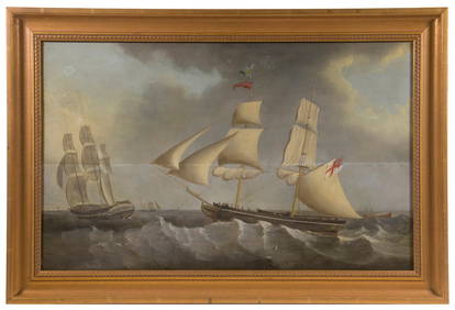
LATE 18TH C. OIL PAINTING OF BRITISH MAN-O-WARThomaston Place Auction Galleries4.4(394)See Sold PriceFeb 24, 2024
EARLY 18TH C. MAP OF ITALY, FRAMEDThomaston Place Auction Galleries4.4(394)See Sold PriceFeb 24, 2024
18TH C. ANTIQUE MAP: FRENCH & INDIAN WAR, FRAMEDThomaston Place Auction Galleries4.4(394)See Sold PriceFeb 24, 2024
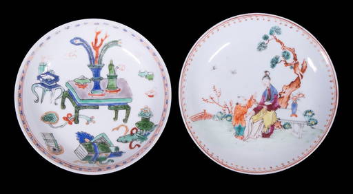
CHINESE KANGXI PERIOD PORCELAIN SAUCERSThomaston Place Auction Galleries4.4(394)See Sold PriceFeb 24, 2024
18th C. Chinese Export Porcelain Posset PotEpic Auctions and Estate Sales4.6(210)See Sold PriceMar 02, 2024
Three 18th C. Chinese Export Porcelain CupsEpic Auctions and Estate Sales4.6(210)See Sold PriceMar 02, 2024
Baker 18th C. Style 3 Drawer Bombe ChestEpic Auctions and Estate Sales4.6(210)See Sold PriceMar 02, 2024
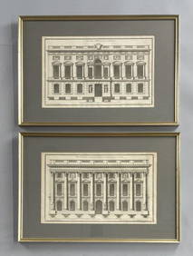
2 Framed 18th C. Parisian Architectural PrintsEpic Auctions and Estate Sales4.6(210)See Sold PriceMar 02, 2024
LOT OF 9 ANTOINE DE MARCENAY ETCHINGS 18th C.Marnie Collection Auction4.5(70)See Sold PriceMar 10, 2024
Two (2) Antique 18th C. Copper Engraved Framed Maps - America & EuropeMagnusson Art Group4.5(53)See Sold PriceMar 14, 2024
Map: An 18thC engraved and hand coloured map of Buckinghamshire after Robert Morden. Approx. 8 1/4"Claydon Auctioneers Ltd4.3(125)See Sold PriceFeb 26, 2024
Map: An 18thC engraved and hand coloured map of Northamptonshire, with description ofClaydon Auctioneers Ltd4.3(125)See Sold PriceFeb 26, 2024
Map: An 18thC engraved and hand coloured map of North America and South America, titled DeClaydon Auctioneers Ltd4.3(125)See Sold PriceFeb 26, 2024
Map: An 18thC engraved map of Bedfordshire titled An Accurate Map of the County of Bedford DividedClaydon Auctioneers Ltd4.3(125)See Sold PriceFeb 26, 2024
Map: An 18thC engraved map titled A New and Improved Map of Oxfordshire.. after Thomas Kitchin.Claydon Auctioneers Ltd4.3(125)See Sold PriceFeb 26, 2024
ANTIQUE 18TH C ENGLISH MALE PORTRAIT OIL PAINTINGAntique Arena Inc.4.5(883)See Sold PriceMar 02, 2024
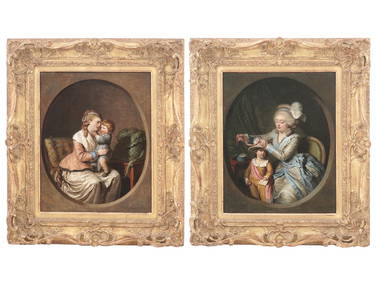
18TH C FRENCH PAINTINGS BY PIERRE ALEXANDRE WILLEAntique Arena Inc.4.5(883)See Sold PriceMar 09, 2024