Vintage Ca. 1940's International Panel Delivery Truck Converted into Stationary Food Truck, WasSwisher Bros. Auction LLC4.4(241)See Sold PriceFeb 25, 2024
Martin Custom Acoustic Guitar 000 Body Style Rosewood with Hard CaseHess Fine Auctions4.5(197)See Sold PriceMar 02, 2024
1968 Gibson LG-0 Acoustic Dreadnought Parlor GuitarHess Fine Auctions4.5(197)See Sold PriceMar 02, 2024
Replica Robinson 1862 Sharps CarbineSchmidt's Antiques Inc. Since 19114.8(431)See Sold PriceMar 02, 2024
PAIR (18th c) OF FLINTLOCK DUELING PISTOLSJohn McInnis Auctioneers,LLC4.6(502)See Sold PriceFeb 24, 2024
PAIR T KETLAND of LONDON .60 CAL FLINTLOCK PISTOLSJohn McInnis Auctioneers,LLC4.6(502)See Sold PriceFeb 25, 2024
Gibson ES335 Semi Hollow Vintage Sunburst Electric Guitar with Certificate of Authenticity Hand MadeHess Fine Auctions4.5(197)See Sold PriceMar 02, 2024
WALT DISNEY WORLD - Figment Animatronic Character Skin from EPCOT's Journey Into ImaginationPropstore4.2(6)See Sold PriceMar 12, 2024
Lot Of 3 Early Large Three-Ring Binders Full Of Thousands Of StampsRbfinearts4.4(571)See Sold PriceFeb 24, 2024
A FINE PERSIAN MALAYER PRAYER RUG WITH CYPRESS C. 1860Soulis Auctions4.8(953)See Sold PriceFeb 24, 2024
Thomas Hart Benton; 20thC. American Regionalist Oil SignedMid-Hudson Auction Galleries4.4(468)See Sold PriceFeb 24, 2024
Fender USA Stratocaster Electric Guitar Classic Candy Red and White Original Stickers with Gig BagHess Fine Auctions4.5(197)See Sold PriceMar 02, 2024
1986 Fender Stratocaster Japan Blue-Green with White Pickguard and Gig Bag JapaneseHess Fine Auctions4.5(197)See Sold PriceMar 02, 2024
LEOPOLD VON BUCH - Carte Physique d'Isle de PalmaLEOPOLD VON BUCH Stolpe, Uckermark 1774 - Berlin 1853 PIERRE ANTOINE TARDIEU in France 1784 - 1869 Carte Physique d'Isle de Palma. Paris, 1824 Copper engraving Signed, titled and dated Size 44.5 x 32.See Sold Price
SoldMalta.- Schmettau (Baron Samuel von) Carte ParticuMalta.- Schmettau (Baron Samuel von) Carte Particuliere de l'Isle de Malte de Goze et Cuming dans l'Etat qui Estoients l'Anne 1724,map showing the islands of Malta, Gozo, and Comino, orientateSee Sold Price
Mittelamerika: Carte des Isles de l'AmeriqueMittelamerika. Mappa Geographica ... Occidentalis partem mediam circum Isthmum Panamensem ... (das Gebiet von Florida bis Venezuela mit Kuba, Jamaica, Santo Domingo, den Bahamas, Antillen u. a. InselnSee Sold Price
SoldGroup of 4 mapsGroup of 4 maps 1). Christoph Fembo- Charte von Frankreich'', 1819; 2). Tobias Mayer- ''Belgii Universi seu Inferioris Germaniae'', 1748; 3). Guillaume Del Isle ''Carte de la Champagne et Des Pays VoiSee Sold Price
SoldKorsika "Carte Nouvell de l'Isle de Corse". Grenzkol.Korsika "Carte Nouvell de l'Isle de Corse". Grenzkol. Kupferstichkarte von R. de Vaugondy, um 1768. 57,8x44,2 cm.See Sold Price
Carte nouvelle de L'Isle de Cadix & du Detroit deCarte nouvelle de L'Isle de Cadix & du Detroit de Gibraltar. Kupferstichkarte von R. A. Schneider in Fürth n. Johann Friedrich Weidler b. Johann Baptist Homann in Nürnberg. Plattenmaße ca. 56 x 48See Sold Price
SoldCarte des Costes Maritimes de Mekelenbourg, doizDeutschland Carte des Costes Maritimes de Mekelenbourg, doiz Iasmont iusquesta l'Isle de Femeren (Carte van de zee Custe va Mekelenborch). Kol. Kupferstichkarte aus der französischen Ausgabe von WaghSee Sold Price
Brue, A. H. Carte physique, administrative et routiereBrue, A. H. Carte physique, administrative et routiere de la France. Grenzkolorierte Stahlstichkarte von Frankreich. 24 Segmente auf Leinwand, Gesamtmaß ca. 160 x 114 cm. Paris, Goujon, 1818. In BuntSee Sold Price
SoldWiebeking (Karl Friedrich R. von) Carte de GrandeWiebeking (Karl Friedrich R. von) Carte de Grande-Bretagne,the British Isles, showing the railways, ports, rivers and canals, the South-East England sheet with inset plan of the London docks,See Sold Price
SoldWiebeking (K. F. R. von) Grande-BretagneWiebeking (Karl Friedrich R. von) Carte de Grande-Bretagne,the British Isles, showing the railways, ports, rivers and canals, the South-East England sheet with inset plan of the London docks,See Sold Price
SoldWiebeking (Karl F R. von) Grande-BretagneWiebeking (Karl Friedrich R. von) Carte de Grande-Bretagne,the British Isles, showing the railways, ports, rivers and canals, the South-East England sheet with inset plan of the London docks,See Sold Price
Chanlaire & Mentelle: Map of Cuba & Bahamas, 1798Carte de l'Isle de Cuba et des Isles Lucayes The superb map of Cuba and the Bahamas (plus the southern tip of Florida) from Chanlaire & Mentelle's Atlas Universel de Geographie Physique et Politique.See Sold Price
SoldTardieu (Pierre François) 4 maps of ScandinaviaTardieu (Pierre François) 4 maps of Scandinavia,Carte Générale et Physique du Royaume de Suède; Suède Moderne; Danemarck, Norwege et Islande; Danemarck Propre, Le Jutland et les Isles, engraveSee Sold Price
Tardieu (Pierre François) 4 maps of ScandinaviaTardieu (Pierre François) 4 maps of Scandinavia,Carte Générale et Physique du Royaume de Suède; Suède Moderne; Danemarck, Norwege et Islande; Danemarck Propre, Le Jutland et les Isles, engraveSee Sold Price
Four maps of portions of Canada by BellinTitle: Four maps of portions of Canada Author: Bellin, Jacques Nicolas Description: Includes: Karte von l'Isle Royale. 17.5x6 cm. * Carte du Golphe de St. Laurent et Pays Voisins pour Servir a l'HistoSee Sold Price
SoldOriginal Antique Map of the Arctic Regions 1791Carte physique de la mer glaciale arctique by Jean Baptiste Nolin. Published in 1791 in Paris, France. From Atlas General, hand colored map. Text in French. Original copper plate engraving printed onSee Sold Price
SoldJacques Nicolas Bellin (1703-1772), "Carte de Isle deJacques Nicolas Bellin (1703-1772), "Carte de Isle de La Jamaique," 1758, hand colored, H. - 8 in., W. - 12 in.See Sold Price
Carte des Isles de Maiorque, Minorque et d'YviceMap: Carte des Isles de Maiorque, Minorque et d'Yvice Cartographer: Lotter Place & Date: Augsburg / 1770 Size: 22" x 18 1/4" Condition: old color (cartouche in b&w) overall age toning and some staininSee Sold Price
SoldMap of Asia. 1854.Print of hand colored steel engraving titled „Carte Physique & Politique de L’Asie“.Drawn by L. Dussieux.Engraved by unknown.From „Atlas General De Geographie physique, politique et historiqueSee Sold Price
SoldHomann Heirs: Antique Composite Map of West Indies 1740Map: Mappa Geographicae, complectens Indiae Occidentalis/ Carte des Isles de l'Amerique Cartographer: Homann Heirs/J.B.B. d'Anville Place & Date: Nurnberg / 1740 Size: 19" x 22 5/8" Condition: Main WeSee Sold Price
Homann Heirs/ d’Anville: West Indies Antique Map, 1740Map: Mappa Geographicae, complectens Indiae Occidentalis/ Carte des Isles de l'Amerique Cartographer: Homann Heirs/J.B.B. d'Anville Place & Date: Nurnberg / 1740 Size: 19" x 22 5/8" Condition: Main WeSee Sold Price
SoldBellin: Madeira and Porto SantoMap Title: Carte des Isles de Madere et Portosanto Cartographer: Bellin Place / Date: Paris / 1746/1760 Size: 8 1/2" x 6 1/8" Bellin's striking map of the Portuguese Atlantic islands of Madeira and PoSee Sold Price
Bonne: Antique Map of the East Indies, 1780Title/Content of Map: 'Carte Des Isles De La Sonde, et des Isles Moluques' A map of the East Indies, the Malay peninsula and the southern Philippines, showing trade winds. Inset of the Moluccas (MalukSee Sold Price
Bonne: Antique Map of the Moluccas, 1780Title/Content of Map: Fine antique map of the Moluccas and North Australia. Carte des Isles de la Sonde et des Isles Moluques par M. Bonne, Inginieur Hydrographe de la Marine Date Printed: 1780 CartogSee Sold Price
QUEEN VICTORIA AUTOGRAPHED CARTE DE VISITE CDV PORTRAITOmnia Auctions4.7(324)See Sold PriceFeb 26, 2024
[BASEBALL]. Carte de Visite Full-Length Portrait of...Potter & Potter Auctions4.6(539)See Sold PriceMar 07, 2024
[BASEBALL CARTE DE VISITE ]. Carte de Visite Photograph of ...Potter & Potter Auctions4.6(539)See Sold PriceMar 07, 2024
[BASEBALL CARTE DE VISITE]. Carte de Visite Photograph of a...Potter & Potter Auctions4.6(539)See Sold PriceMar 07, 2024
[BASEBALL CARTE DE VISITE]. Carte de Visite Photograph of F...Potter & Potter Auctions4.6(539)See Sold PriceMar 07, 2024
Map of St. Kitts and Nevis Depot de la Marine, Paris, 1758Global Auctions Company4.3(36)See Sold PriceMar 03, 2024
Four Victorian carte de visite photograph albums containing various portrait cards and photographs,Claydon Auctioneers Ltd4.3(125)See Sold PriceFeb 26, 2024
1760 MAP CARTE PARTICULIERE DE L'ISLE DE JUAN FERNANDES antique Robinson CrusoeJasper524.5(9.8k)See Sold PriceFeb 27, 2024
Unique collection of 18 carte de visites of Queen Victoria’s familyJasper524.5(9.8k)See Sold PriceFeb 27, 2024
1764 Bellin Map of Mari-Galante Near Guadeloupe -- Carte de l'Isle de Mari-GalanteJasper524.5(9.8k)See Sold PriceFeb 27, 2024
1764 Bellin Map of St. Kitts -- Carte de l'Isle St. ChristopheJasper524.5(9.8k)See Sold PriceFeb 27, 2024
1764 Bellin Map of Antigua -- Carte de l'Isle d'Antigue Situee par la Latitude 17 Degres et par laJasper524.5(9.8k)See Sold PriceFeb 27, 2024
1845 Delisle/Bauche Map of Martinique -- Carte de l'Isle de la Martinique Colonie Francoise de l'uneJasper524.5(9.8k)See Sold PriceFeb 27, 2024
Carte du Canal de Mosambique…. Madagascar Bonne Esperance. BONNE 1780 mapJasper524.5(9.8k)See Sold PriceFeb 28, 2024
Carte de la Guinée, contenant…'. Guinea & Cape Verde islands. BONNE 1771 mapJasper524.5(9.8k)See Sold PriceFeb 28, 2024
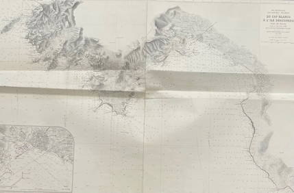
MER MEDITERRANEE ILES BALEARES MAJORQUE/ DU CAP BLANCO A L'ILE DRACONERA/ 1890Churchill Galleries3.7(213)See Sold PriceFeb 26, 2024
A Large Collection of Carte De Visite Photographs,Flints Auctions Ltd4.4(71)See Sold PriceFeb 29, 2024


![[BASEBALL]. Carte de Visite Full-Length Portrait of... (1 of 1)](https://p1.liveauctioneers.com/928/318880/171361328_1_x.jpg?height=282&quality=70&version=1707501302)
![[BASEBALL CARTE DE VISITE ]. Carte de Visite Photograph of ... (1 of 2)](https://p1.liveauctioneers.com/928/318880/171361404_1_x.jpg?height=282&quality=70&version=1707501302)
![[BASEBALL CARTE DE VISITE]. Carte de Visite Photograph of a... (1 of 2)](https://p1.liveauctioneers.com/928/318880/171361405_1_x.jpg?height=282&quality=70&version=1707501302)
![[BASEBALL CARTE DE VISITE]. Carte de Visite Photograph of F... (1 of 2)](https://p1.liveauctioneers.com/928/318880/171361408_1_x.jpg?height=282&quality=70&version=1707501302)