SoldLAURIE & WHITTLE. Chart containing the CoastsLAURIE & WHITTLE. Chart containing the Coasts of California, New Albion [etc.] / North America and the West Indies. Together, 2 engraved folding maps joined, issued separately but intended to be joineSee Sold Price
SoldLaurie and Whittle Coast of India Sea Chart 1794Robert Laurie (ca. 1755–1836) and James Whittle (1757-1818), "The Coast of India from Pulo Timon to Pulo Cambir Comprehending the Malayan Coast, The Gulf of Siam, the Coasts of Tsiampa and CochSee Sold Price
SoldHalley (Edmond) A Chart of the Coast of China[Halley (Edmond)] A Chart of the Coast of China from Cambodia to Nanquam with part of Japan, engraved chart, 505 x 600mm., central vertical fold, [1728] § Laurie & Whittle. A New chart of theSee Sold Price
SoldA new chart of the Coast of Brazil 05/12/1794Published Laurie & Whittle, London, 43" X 31" includes frameSee Sold Price
SoldLaurie & Whittle (Publishers, fl. 1794 - 1812) A gLaurie & Whittle (Publishers, fl. 1794 - 1812) A group of 7 charts of the coast of India,including a Chart of the Northern Part of the Bay of Bengal, the Gulf of the Bay of Bengal, the Mouth oSee Sold Price
SoldLaurie & Whittle - Map of the North American CoastA New and Accurate Chart (From Captain Holland's Surveys) of the North American Coast for the Navigation Between the Gulf of Florida and Philadelphia, published by Robert Laurie and James Whittle, LonSee Sold Price
SoldLaurie & Whittle - Map of the North American CoastA New and Correct Chart from Captain Holland's Surveys of the North American Coast for the Navigation Between Halifax and Philadelphia, published by Robert Laurie and James Whittle, London, 1798-1800,See Sold Price
SoldLaurie & Whittle, Chart of Newfoundland, 1803[Chart/Newfoundland]. A Chart Of The Banks Of Newfoundland, Drawn from a Great Number of Hydrographical Surveys, Chiefly from those of Chabert, Cook, Fleurieu, and current Observations of Frans. Owen.See Sold Price
SoldSAYER and BENNETT. Chart, containing the CoastSAYER and BENNETT. Chart, containing the Coasts of California, New Albion, and Russian Discoveries to the North [etc.] / North America and the West Indies. Engraved two-sheet folding map joined, 460x1See Sold Price
SoldSayer & Bennett N. America MapRobert Sayer, English, 1725-1794, and John Bennett, English, fl. 1770-1784. Engraved map with hand colored outline is fully titled "Chart containing the Coasts of California, New Albion, and Russian DSee Sold Price
Sold[MAP]. SAYER. Coasts of California.... London, 1775369. [MAP]. SAYER, R[obert] & J[ohn] Bennett (publishers) & [Thomas Jefferys (engraver)]. [Title on left sheet] Chart, containing the Coasts of California, New Albion, and Russian DiscoveriesSee Sold Price
SoldNorth America with Pacific & Atlantic 1775Title: Chart, Containing the Coasts of California, New Albion, and Russian Discoveries to the North; with the Peninsula of Kamtschatka, in Asia, Opposite thereto / North America and the West Indies, wSee Sold Price
LAURIE & WHITTLE: "A New Chart of the Java Sea, withinLAURIE & WHITTLE: "A New Chart of the Java Sea, within the Isles of Sunda; with its Straits, and the Adjacent Seas." London, 1799; 59 x 87 cm. A stunning chart of the Java Sea including part of SumSee Sold Price
18th C English Chart ofPublished 12 May 1794 by Laurie WhittleA New Chart of the Coast of Spain and Portugal from Cape Penas to the Streights of Gibraltar29in x 60inSee Sold Price
SoldTWO BLUEBACK CHARTS PUBLISHED BY RICHARD H. LAURIE,TWO BLUEBACK CHARTS PUBLISHED BY RICHARD H. LAURIE, LONDON 1) "A General Chart of the Coasts of Brasil, &c. From the River Para to Buenos Ayres ...". Circa 1842. 38.5" x 77". 2) "The Southern Part ofSee Sold Price
TWO BLUEBACK CHARTS PUBLISHED BY RICHARD H. LAURIE,TWO BLUEBACK CHARTS PUBLISHED BY RICHARD H. LAURIE, LONDON 1) "A General Chart of the Coasts of Brasil, &c. From the River Para to Buenos Ayres ...". Circa 1842. 38.5" x 77". 2) "The Southern Part ofSee Sold Price
TWO BLUEBACK CHARTS PUBLISHED BY RICHARD H. LAURIE,TWO BLUEBACK CHARTS PUBLISHED BY RICHARD H. LAURIE, LONDON 1) "A General Chart of the Coasts of Brasil, &c. From the River Para to Buenos Ayres ...". Circa 1842. 38.5" x 77". 2) "The Southern Part ofSee Sold Price
South Coast of England. 175x65cm. Imray Laurie Norie Wilson sea chart 1913 mapTitle: South Coast of England. 175x65cm. Imray Laurie Norie Wilson sea chart 1913 map Description: South Coast of England from the Owers to Bridport // Sketch of Bridport Harbour // Poole Bar // WeymoSee Sold Price
Sold1794 Laurie & Whittle Map of the Caribbean, Mexico andTitle/Content of Map: 1794 Laurie & Whittle Map of the Caribbean, Mexico and Central America -- A New and Complete Map of the West Indies Comprehending All the Coasts and Islands Known by That Name bySee Sold Price
Laurie & Whittle: Antique Map of Straits of Bali, 1794Title/Content of Map: 'A new plan of the Straits situated to the East of Java & Madura, commonly called The Straits of Bali and of Pondi and Respondi' A sea chart of the Bali Strait between east JavaSee Sold Price
SoldAfter Samuel Dunn, New Chart of the World MapAfter Samuel Dunn (British, 18th century), "A New Chart of the World of Mercator's Projection: with The Tracks & Discoveries of the Latest Circumnavigators", published by Laurie & Whittle, London, EngSee Sold Price
SoldA box containing assorted 18th century and later printsA box containing assorted 18th century and later prints. Comprising: 'Veue du Chateau de Versailles', Rigaud after Tinney, published 12th May, 1794, by Laurie & Whittle, plate impression size 9.5" x 1See Sold Price
Scandinavia.- Laurie & Whittle (publishers) A New MapScandinavia.- Laurie & Whittle (publishers) A New Map of the Northern States containing the Kingdoms of Sweden, Denmark, and Norway; with The Western Parts of Russia, Livonia, Courland &ca., engravedSee Sold Price
A box containing assorted 18th century and later printsA box containing assorted 18th century and later prints. Comprising: 'Veue du Chateau de Versailles', Rigaud after Tinney, published 12th May, 1794, by Laurie & Whittle, plate impression size 9.5" x 1See Sold Price
LATE 18TH C. VERY LARGE CHART OF NORTHEAST CANADA BY DES BARRES (1721-1824), 1780, FRAMEDThomaston Place Auction Galleries4.4(393)See Sold PriceFeb 24, 2024
CHART "SOUTHERN COAST OF LONG ISLAND FROM MONTAUK POINT TO EAST HAMPTON" Circa 1877 11.25" x 22.75"Eldred's4.7(419)See Sold PriceFeb 27, 2024
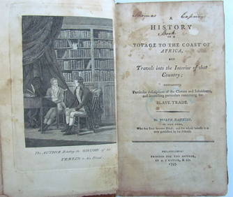
1797 HISTORY OF VOYAGE TO COAST of AFRICA by JOSEPH HAWKINS antique 1st EDITIONJasper524.5(9.9k)See Sold PriceFeb 27, 2024
1816 MAP NORTHERN PART OF RUSSIA or MUSCOVY in EUROPE copper engraving ANTIQUEJasper524.5(9.9k)See Sold PriceFeb 27, 2024
West Indies. South Coast of Jamaica from Port Royal to Pedro Bluff.Jasper524.5(9.9k)See Sold PriceFeb 27, 2024
Southern Africa Cape of Good Hope-Madagascar ADMIRALTY sea chart 1935 (1955) mapJasper524.5(9.9k)See Sold PriceFeb 28, 2024
West coast of Africa from Cape Blanco… Arguin bay, Mauritania. LABAT 1745 mapJasper524.5(9.9k)See Sold PriceFeb 28, 2024
Carte de la Guinée, contenant…'. Guinea & Cape Verde islands. BONNE 1771 mapJasper524.5(9.9k)See Sold PriceFeb 28, 2024
South Namibia coast. Walvis Bay-Orange River ADMIRALTY sea chart 1881 (1954) mapJasper524.5(9.9k)See Sold PriceFeb 28, 2024
East coast of Africa from the Cape… South Africa Mozambique. CHILD 1745 mapJasper524.5(9.9k)See Sold PriceFeb 28, 2024
Western coast of Africa… to the River Sanaga. Southern Mauritania LABAT 1745 mapJasper524.5(9.9k)See Sold PriceFeb 28, 2024
CHARTS: United States - East Coast New Jersey/ PASSAIC AND HACKENSACK RIVERSChurchill Galleries3.7(217)See Sold PriceFeb 26, 2024
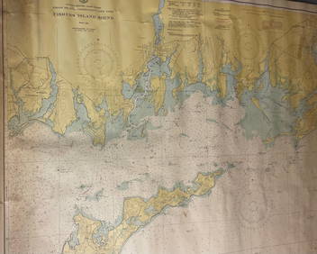
CHART: UNITED STATES - EAST COAST/ RHODE ISLAND - CONNECTICUT - NEW YORK/ Fishers IslandChurchill Galleries3.7(217)See Sold PriceFeb 26, 2024
CHART: UNITED STATES - EAST COAST MASSACHUSETTS/ HYANNIS HARBORAND VICINITYChurchill Galleries3.7(217)See Sold PriceFeb 26, 2024
Chart: United States- East Coast/ NORTH CAROLINA/ RIVER INLET TO CAPE FEAR.Churchill Galleries3.7(217)See Sold PriceFeb 26, 2024
CHART: UNITED STATES - EAST COAST NEW YORK/ HUDSON RIVER/ POUGHKEEPSIE TO HUDSONChurchill Galleries3.7(217)See Sold PriceFeb 26, 2024


![[MAP]. SAYER. Coasts of California.... London, 1775 (1 of 4)](https://p1.liveauctioneers.com/514/38482/16500438_1_x.jpg?height=282&quality=70&version=1363615005)