SoldLarge map of Franklin's 2nd Arctic ExpeditionHeading: (Arctic) Author: Walker, J. & C. Title: Discoveries of the Expedition under the Command of Captain Franklin, R.A., Near the Mouth of the Mackenzie River and on the Sea Coast East & West. A.D.See Sold Price
Large map of Franklin's 2nd Arctic ExpeditionHeading: Author: Walker, J. & C. Title: Discoveries of the Expedition under the Command of Captain Franklin, R.A., Near the Mouth of the Mackenzie River and on the Sea Coast East & West. A.D. 1825-26See Sold Price
SoldPolar.- Expedition in search of Sir John Franklin.-Polar.- Expedition in search of Sir John Franklin.- Arctic Expedition in search of Sir John Franklin, printed flyer, slightly browned in right margin, 100 x 165mm., watermark "185-", Printed on boardSee Sold Price
Sold1856 1st ed Elisha Kane Arctic Explorations Voyages1856 1st ed Elisha Kane Arctic Explorations Voyages Franklin Expedition Map 2v The Arctic Exploration, or ‘Advance,’ led by Elisha Kent Kane, was financed to find Sir John Franklin and his ship whSee Sold Price
Sold1856 1st ed Elisha Kane Arctic Explorations Voyages1856 1st ed Elisha Kane Arctic Explorations Voyages Franklin Expedition Map 2v The Arctic Exploration, or ‘Advance,’ led by Elisha Kent Kane, was financed to find Sir John Franklin and his ship whSee Sold Price
Sold1856 1st ed Elisha Kane Arctic Explorations Voyages1856 1st ed Elisha Kane Arctic Explorations Voyages Franklin Expedition Map 2v The Arctic Exploration, or ‘Advance,’ led by Elisha Kent Kane, was financed to find Sir John Franklin and his ship whSee Sold Price
Sold1856 1st ed Elisha Kane Arctic Explorations Voyages1856 1st ed Elisha Kane Arctic Explorations Voyages Franklin Expedition Map 2v The Arctic Exploration, or ‘Advance,’ led by Elisha Kent Kane, was financed to find Sir John Franklin and his ship whSee Sold Price
SoldArctic Explorations Reference [135979]1858 edition by Elisha Kane Arctic Explorations Voyages Franklin Expedition Map 2v The Arctic Exploration, or 'Advance,' led by Elisha Kent Kane, was financed to find Sir John Franklin and his ship whSee Sold Price
SoldA Relic from the Ill-fated Adolphus Greely 1881A Relic from the Ill-fated Adolphus Greely 1881 Lady Franklin Bay Arctic Expedition from the CollectioSee Sold Price
Sold1857 Elisha Kane Arctic Explorations Voyage Franklin1857 Elisha Kane Arctic Explorations Voyage Franklin Expedition Maps Illustrated The Arctic Exploration, or ‘Advance,’ led by Elisha Kent Kane, was financed to find Sir John Franklin and his shipSee Sold Price
SoldNarrative of the Arctic Land Expedition to the MoAuthor: Back, Captain [George] Description: viii, 338 pp. Large folding map. 8¾x5¼, modern half green morocco and marbled boards. Edges untrimmed. First Paris Edition. Narrative of Back's overland eSee Sold Price
SoldHall Second Arctic ExpeditionHall (Captain Charles Francis) Narrative of the Second Arctic Expedition,portrait frontispiece, plates, illustrations, large linen-backed folding map in pocket at end, water-stained, modern buSee Sold Price
Sold1856 1st ed Arctic Explorations Elisha Kane Voyages1856 1st ed Arctic Explorations Elisha Kane Voyages Franklin Expedition Map 2v The Arctic Exploration, or ‘Advance,’ led by Elisha Kent Kane, was financed to find Sir John Franklin and his ship whSee Sold Price
Sold1854 Elisha Kane Arctic Explorations Voyages Franklin1854 Elisha Kane Arctic Explorations Voyages Franklin Grinnell Expedition Map The Arctic Exploration, or ‘Advance,’ led by Elisha Kent Kane, was financed to find Sir John Franklin and his ship whiSee Sold Price
SoldBACK, George.Narrative Of The Arctic Land Expedition To The Mouth Of The Great Fish River. 8vo. pp. x, [2], 663, [1]. large folding engraved map & 16 engraved & lithographed plates. 8 text illus. original blind-stSee Sold Price
MAP, Northern Canada, Arctic, FranklinNorthern Canada, Arctic Regions. Rear Admiral Sir John Franklin, The Discoveries of the Expedition Under the Command of Captain Franklin R.D. Near the Mouth of the Mackenzie River, and on the Sea CoasSee Sold Price
Sold1886 1ed Greely Arctic Explorations Voyages Expedition1886 1ed Greely Arctic Explorations Voyages Lady Franklin Bay Expedition Map 2v This ‘Three years of Arctic service’ is a narrative by Adolphus Greely of the United States expedition Lady FranklinSee Sold Price
Sold1859 McLintock Voyage in Arctic Seas Narrative1859 McLintock Voyage in Arctic Seas Narrative of John Franklin Expedition MAPS Sir John Franklin was a 19th-century British Royal Navy officer most-remembered for his explorations of the Arctic. HisSee Sold Price
Sold[POLAR EXPLORATION] GLEN, A.R.; CROFT, N.A.C. Under the[POLAR EXPLORATION] GLEN, A.R.; CROFT, N.A.C. Under the Pole Star: The Oxford University Arctic Expedition 1935-6. London: Methuen Publishers, [1937]. Large 8vo. FIRST EDITION, FIRST PRINTING. IllustrSee Sold Price
Elisha Kent KANE; Sir John FRANKLIN [Polar Exploration;Very Scarce Signature of Arctic Explorer Sir John Franklin. Kane’s Arctic Explorations (spine title); Kane, Elisha Kent. Arctic Explorations The Second Grinnell Expedition in Search of SirSee Sold Price
Sold1852 1ed Arctic Regions Voyages John Franklin Simmonds1852 1ed Arctic Regions Voyages John Franklin Simmonds Grinnell Expedition MAP Sir John Franklin was a 19th-century British Royal Navy officer most-remembered for his explorations of the Arctic. His fSee Sold Price
SoldWinfield S Schley REPORT OF WINFIELD S SCHLEY COMMANDERWinfield S Schley REPORT OF WINFIELD S SCHLEY COMMANDER US NAVY COMMANDING GREELEY RELIEF EXPEDITION OF 1884 1887 Antique Illustrated Plates Maps Polar Arctic Exploration Lady Franklin Bay Adolphus GrSee Sold Price
SoldPolar.- Arctic.- Franklin (Sir John).- ShillinglawPolar.- Arctic.- Franklin (Sir John).- Shillinglaw (John J.) A Narrative of Arctic Discovery...with the details of the measures adopted...for the relief of the expedition under Sir John Franklin, firsSee Sold Price
SoldPolar.- Back (Sir George) Narrative of the Arctic LandPolar.- Back (Sir George) Narrative of the Arctic Land Expedition, first edition, folding map and 16 engraved and lithograph plates, some foxing, original cloth, very good copy, 1836 § Franklin (See Sold Price
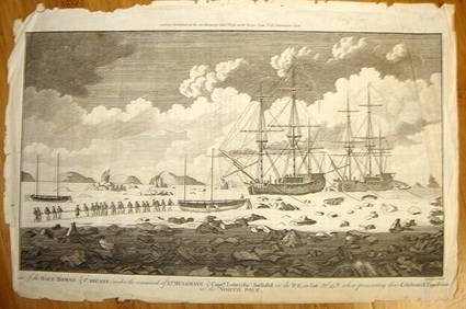
ALEXANDER HOGG ca1790 Engraving Captain Mulgrave Ships Ice Bound Cpt CookLuis Porretta Fine Arts4.3(10)See Sold PriceMar 02, 2024
Large Egyptian Expedition Lithograph Print with HieroglyphsTimeLine Auctions Ltd.4.5(183)See Sold PriceMar 06, 2024
Pair of Early Railroad Maps - 1862 Pittsburgh, Ft. Wayne & Chicago Railway and 1873 PennsylvaniaRail & Road Auctions4.6(165)See Sold PriceMar 07, 2024
1867 Map of the Railroads of The State of New YorkRail & Road Auctions4.6(165)See Sold PriceMar 08, 2024
D'Entrecasteaux - Australia: Coasts of Van Diemen's Land (New Holland). 9Trillium Antique Prints & Rare Books4.5(30)See Sold PriceFeb 24, 2024
D'Entrecasteaux - Tasmania, Australia: Map of the Northern Portion of Recherche Bay. 5Trillium Antique Prints & Rare Books4.5(30)See Sold PriceFeb 24, 2024
D'Entrecasteaux - Australia: Chart of Van Diemen's Land (New Holland). 3Trillium Antique Prints & Rare Books4.5(30)See Sold PriceFeb 24, 2024
D'Entrecasteaux - Map of Australia (New Holland), New Zealand, and southern Asia and surroundingTrillium Antique Prints & Rare Books4.5(30)See Sold PriceFeb 24, 2024
1856 ARCTIC EXPLORATIONS 2nd GRINNEL EXPEDITION 2 v. E.KANE antique ILLUSTRATEDJasper524.5(9.8k)See Sold PriceFeb 27, 2024
Pre-colonial Africa. Mountains of Kong/Moon. Caravan routes. THOMSON 1817 mapJasper524.5(9.8k)See Sold PriceFeb 28, 2024
Africa inc. discoveries of Livingstone Barth Vogel Chadda Exp. SWANSTON 1860 mapJasper524.5(9.8k)See Sold PriceFeb 28, 2024
Stanford, Edward 1901 Large Map. Geological Map of the British IslesAlbion Auctions4.6(336)See Sold PriceMar 01, 2024
Perry, Matthew C. 1856 Large Map. Shah Bay, Lew Chew I. JapanAlbion Auctions4.6(336)See Sold PriceMar 01, 2024
THE ANTIQUE ILLUSTRATED BOOK "1856 ARCTIC EXPLORATIONS: SECOND GIRNEL EXPEDITION 2" BY E. KANENY Elizabeth 4.3(84)See Sold PriceMar 03, 2024
Henri-Joseph Redouté - Large Folio Botanical Print - Plants in Egypt - Fagonia latifoliaProverde Auctions4.3(3)See Sold PriceFeb 28, 2024
Robert de Vaugondy - Map of Canada - Mer de l' Ouest or Sea of the West and a Northwest PassageProverde Auctions4.3(3)See Sold PriceFeb 28, 2024


![Arctic Explorations Reference [135979] (1 of 2)](https://p1.liveauctioneers.com/2699/211842/108080377_1_x.jpg?height=282&quality=70&version=1626732910)


![[POLAR EXPLORATION] GLEN, A.R.; CROFT, N.A.C. Under the (1 of 3)](https://p1.liveauctioneers.com/928/178407/89893873_1_x.jpg?height=282&quality=70&version=1599515639)