Johnston (W. & A.K.) Three Miles to Inch Map of EnJohnston (W. & A.K.) Three Miles to Inch Map of England and Waleson 21 sheets (of 25), lacking sheet 10, 13, 14, 19, with Index sheet, colour lithographs, each sheet c.510 x 660mm., linen backSee Sold Price
SoldJohnston (W. & A.K.) Three Miles to Inch Map of EnJohnston (W. & A.K.) Three Miles to Inch Map of England and Waleson 21 sheets (of 25), lacking sheet 10, 13, 14, 19, with Index sheet, colour lithographs, each sheet c.510 x 660mm., linen backSee Sold Price
Johnston's New 2 Miles to 1 Inch Map. Sheet 30Title/Content of Map: Johnston's New 2 Miles to 1 Inch Map. Sheet 30 Kirkcudbright and Wigtown Date: 1960 ca. Cartographer: JOHNSTON, W. & A.K. | G. W. BACON LTD. Size: 28.5X34 Folding topographic andSee Sold Price
SoldJohnston (W. & A.K.) AustraliaJohnston (W. & A.K.) Australia,on a scale of 53 miles to the inch, with inset map of Tasmania, engraved map with full original hand-colouring, 1075 x 1275mm., dissected and linen-backed, in coSee Sold Price
SoldThree maps to include: (1) North America by AThree maps to include: (1) North America by A.K. Johnston FRGS marked lower right: Engraved by W & AK Johnston sight size: 24 3/4" x 20" (2) Amerique Septentrionale sight size: 12 1/2" x 18 1/4"See Sold Price
12 Inch Terrestrial Globe by W. & A.K. Johnston.Title/Content of Map: 12 Inch Terrestrial Globe by W. & A.K. Johnston.A.J. Nystrom & Co. Date: 1949 ca. Limited. geographers engravers, printers. Edinburgh, Scotland. Scale: 1 inch on globe representsSee Sold Price
Johnston's Touring and Motoring Map of England AndReserve Reduced! Item: Johnston's Touring and Motoring Map of England And Wales, Date: 1920 ca. Cartographer: JOHNSTON, W. & A.K. Publisher: W. & A.K. JOHNSTON Size (inches): 44.25X34.75 showing the mSee Sold Price
SoldGeological Map of the United States and British NorthTitle: Geological Map of the United States and British North America... Publication Date: 1855 Cartographer: JOHNSTON, W. & A.K./H.D. ROGERS Publisher: WILLIAM BLACKWOOD & SONS Size (inches): 20 x 24.See Sold Price
Three 19th C. Asian Maps, c.1820 & c.1860Three 19th C. Asian Maps, China c.1820 Engraved by Anthony Finley, American, 1784-1836; China and Japan F.R.S.E. (with) Islands of Japan. Engraved & printed by W. & A.K. Johnston, Edinburgh. William BSee Sold Price
India.Reserve Reduced! Item: India. Date: 1857 Cartographer: Publisher: W. & A.K. JOHNSTON/E. STANFORD Size (inches): 24.2X20.2 Dissected, linen mounted, folding map with insets "Map of existing and proposeSee Sold Price
Chart of the World On Mercator's Projection,Map: Chart of the World On Mercator's Projection, Publication Date: 1845 Cartographer: JOHNSTON, A. K. Publisher: JOHN JOHNSTONE AND W. & A.K. JOHNSTON Size (inches): 19.6X23.3 "by A.K. Johnson..." PlSee Sold Price
Sold12-inch Terrestrial Globe and Stand by W. & A.K.12-inch Terrestrial Globe and Stand by W. & A.K. Johnston, Edinburgh, on a spelter three-leg stand with bronze patina, ht. 20 1/2 in.See Sold Price
12-inch Terrestrial Globe and Stand by W. & A.K.12-inch Terrestrial Globe and Stand by W. & A.K. Johnston, Edinburgh, on a spelter three-leg stand with bronze patina, ht. 20 1/2 in.See Sold Price
Map of North AmericaMap of North America, W. & A.K. Johnston, Johnston, Keith, 1883, Folio – 17.25 H X 22.50 W Inches, "by Keith Johnston, F.R.S.E." Please note that this lot has a confidential reserve. When you leaveSee Sold Price
Johnston: Antique Map of the West India Islands, 1855Map: West India Islands Publication Date: 1855 Authors: JOHNSTON, A.K., JOHNSTON, A.K. Publisher: JOHNSTON, A.K. Size: Double Folio – 19.80 H x 24.00 W Inches Map showing the West Indies, outline coSee Sold Price
SoldJohnston - 18" Terrestrial Library Floor GlobeJOHNSTON, W. & A.K. An 18-inch Terrestrial Library Floor Globe. Edinburgh and London, early 20th century. 40 inches high x 24 inch diameter. Retail: $15,000. [Signed] within a circular cartouche: "18See Sold Price
SoldA W. & A.K. JOHNSTON 12 INCH TERRESTRIAL GLOBEA 1920's era 12 inch table top globe by W. & A.K. Johnston Ltd., and distributed by A.J. Nystrom & Co. in Chicago. Includes metal latitude circle and wooden equatorial, month and zodiacal ring. CastSee Sold Price
SoldUnusual Early Edwardian Project MapJohnston, W. & A. K. United States & Mexico constructed and engraved by W. & A.K. Johnston... Lithographed map. c. 1903. 41" x 49 ¼" sheet. Handsome and artistic schoolroom map on spring roller witSee Sold Price
Sold1916 Monumental Wall Map: South AmericaW & A.K. Johnston Unrivaled Map. Monumental school map of South America. Matted and framed in oak behind plexiglass. Good condition 50" x 62" Out-of-town buyers must arrange freight shipmentSee Sold Price
Johnston (W. & A.K.) Spain and PortugalJohnston (W. & A.K.) Spain and Portugal,engraved map with original hand-colouring in outline, 530 x 650mm., central vertical fold, slight browning, a short tear in the right margin, mid 19th cSee Sold Price
Sold1916 Monumental Antique Wall Map AsiaW & A.K. Johnston Unrivaled Map. Oak frame. Matted. 50" x 62" Some yellowing at base of map. Otherwise good condition Out-of-town buyers must arrange freight shipmentSee Sold Price
SoldW & A.K. Johnston Terrestrial 8 Inch GlobeCast iron tripod stand. height 16 inches.See Sold Price
1879 Map of IrelandTitle: 1879 Map of Ireland Author: Johnston Medium: Ink on Paper Dimension: 21"X25.5" Description: Map of Ireland dated 1879. Engraved by W & A.K. Johnston. Elephant folio map. Key located upper left.See Sold Price
SoldHoldich (Colonel Sir Thomas) TibetHoldich (Colonel Sir Thomas) Tibet, the Mysterious,first edition, frontispiece and plates, folding colour map by W. & A.K. Johnston, half-title, original gilt pictorial cloth, lower cover dampSee Sold Price
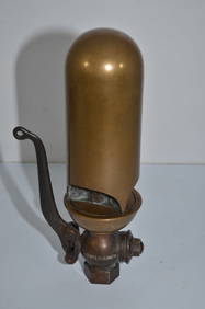
Lunkenheimer Three Inch Three Chime Brass Steam WhistleJM Hobby Supply and Railroad Artifact Auctions4.4(127)See Sold PriceFeb 24, 2024
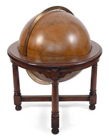
MONUMENTAL FLOOR-STANDING W. & A.K. JOHNSTON 30-INCH TERRESTRIAL GLOBE Edinburgh and London,Eldred's4.7(419)See Sold PriceFeb 28, 2024
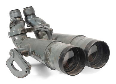
PAIR OF WORLD WAR II JAPANESE NAVAL BINOCULARS CAPTURED BY H.M.S. "EURYALUS" 1943-1945 Case heightEldred's4.7(419)See Sold PriceFeb 27, 2024
Vintage County Map Of NY State Plate EngravingThe Benefit Shop Foundation Inc.4.3(2.9k)See Sold PriceFeb 28, 2024
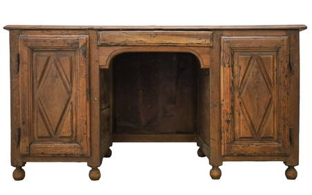
Antique 17th C English Geometric Oak Chest of DrawersKavanagh Auctions4.6(311)See Sold PriceFeb 24, 2024
Rand McNally Railroad Map Cabinet w/ 21 Railroad MapsRail & Road Auctions4.6(165)See Sold PriceMar 08, 2024
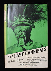
THE LAST CANNIBALS by JENS BJERRE 1957 Fine or Near FineNorth American Artifact Auctions4.7(198)See Sold PriceApr 20, 2024
NORTH WEST AFRICA Maghreb Morocco Tunisia Algeria JOHNSTON 1897 old mapJasper524.5(9.9k)See Sold PriceFeb 28, 2024
MAGHREB. North Africa Morocco Algeria & Tunisia. JOHNSTON 1913 old antique mapJasper524.5(9.9k)See Sold PriceFeb 28, 2024
NORTH AFRICA. 'Biledulgerid', a former North African country. MALLET 1683 mapJasper524.5(9.9k)See Sold PriceFeb 28, 2024
AFRICA NW & SOUTH. Maghreb. Cape Colony electoral divisions. JOHNSTON 1906 mapJasper524.5(9.9k)See Sold PriceFeb 28, 2024
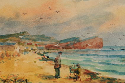
Martha Elizabeth Burchfield-Richter (1924 - 1977) AmericanCutler Bay Auctions4.5(174)See Sold PriceFeb 29, 2024
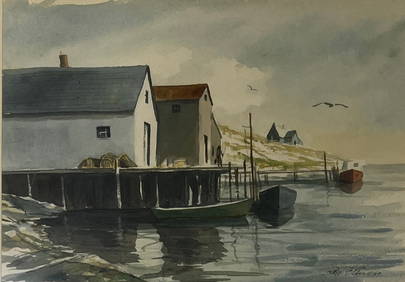
Birge (Lovell Birge) Harrison (1854 - 1929) AmericanCutler Bay Auctions4.5(174)See Sold PriceFeb 29, 2024
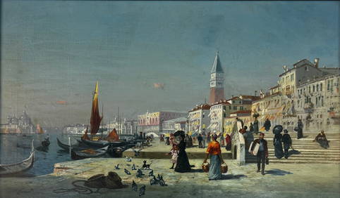
Antonietta Brandeis (1848/9 - 1920/26) Czech Republic/Italy/AustriaCutler Bay Auctions4.5(174)See Sold PriceFeb 29, 2024