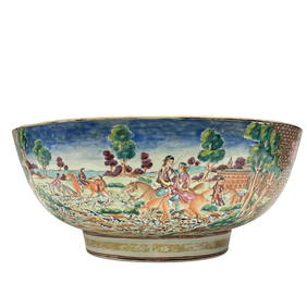
Important Qianlong Chinese Export Hunt Scene BowlPremier Auction Galleries4.3(329)See Sold PriceMar 09, 2024
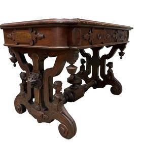
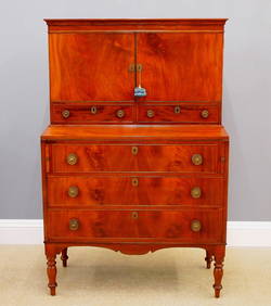
American Renaissance Revival Carved Partners DeskPremier Auction Galleries4.3(329)See Sold PriceMar 09, 2024
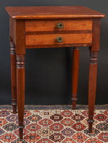
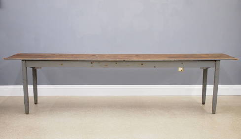
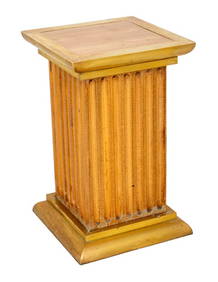
(19th c) CHERRY, MAHOGANY & MAPLE (2) DRAWER STANDJohn McInnis Auctioneers,LLC4.6(504)See Sold PriceFeb 24, 2024
Louis XV Style Marquetry Inlaid Writing DeskNadeau's Auction Gallery4.7(405)See Sold PriceFeb 24, 2024
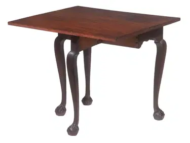
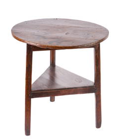
RARE DIMINUTIVE CHIPPENDALE SINGLE DROP-LEAF TABLEThomaston Place Auction Galleries4.4(389)See Sold PriceFeb 24, 2024
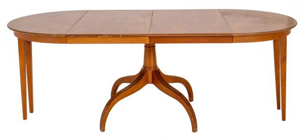
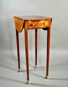
A Fine and Rare Small George III Rosewood and Satinwood Pembroke TableNeue Auctions4.6(356)See Sold PriceMar 02, 2024
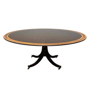
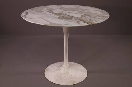
20th C. Five Foot Round Banded Mahogany Pedestal TablePremier Auction Galleries4.3(329)See Sold PriceMar 09, 2024
SoldJohnson: Map of North & South Carolina, 1863Johnson’s North and South Carolina, Johnson & Ward, 1863. 17 x 24 inches. A beautiful example of A. J. Johnson's 1863 map of North Carolina and South Carolina. Offers a fascinating snapshot of theseSee Sold Price
SoldAntique Johnson's Map of North & South Carolina.Antique Johnson's Map of North & South Carolina. An engraved, hand-colored map of North and South Carolina, printed by Johnson and Ward. Most likely the 1866 edition, based on the vignettes, the smallSee Sold Price
Johnson: Map of North & South Carolina, 1864Map: 1864 Johnson Map of North and South Carolina -- Johnson's North and South Carolina Cartographer: Johnson & Ward Year / Place: 1864, New York Map Dimensions: 17.3 x 24 in. An excellent, large mapSee Sold Price
SoldJohnson: Map of North & South Carolina, 1864Map: 1864 Johnson Map of North and South Carolina Maker: Johnson and Ward Published: 1864, New York Size: 17.3 X 23.8 in. Excellent and highly detailed map of the Carolinas, showing the counties colorSee Sold Price
Sold1865 A.J. Johnson Map of North & South Carolina,handcolored, image area approx. 17" x 23".See Sold Price
SoldJohnson’s Map Of North And South Carolinahand colored inset views of "Chimney Rocks and French Broad River", "Table Mountain", and "Plan of Charleston, Vicinity and Harbor",See Sold Price
Sold1864 Johnson Map of North and South Carolina --Title/Content of Map: 1864 Johnson Map of North and South Carolina -- Johnson's North and South Carolina Date: 1864, New York Cartographer: Johnson & WardSize: 17.3 x 24 in. An excellent, large, doublSee Sold Price
Sold1862 Johnson Map of North and South Carolina --Title/Content of Map: 1862 Johnson Map of North and South Carolina -- Johnson's North and South Carolina Date: 1864, New York Cartographer: Johnson & Browning Size: 17.3 x 24 in. This is an excellent,See Sold Price
Sold1864 Johnson Map of North and South Carolina --Title/Content of Map: 1864 Johnson Map of North and South Carolina -- Johnson's North and South Carolina Date Printed: 1864, New York Cartographer: Johnson & Ward Size: 17.3 x 24 in. An excellent, larSee Sold Price
Sold1864 Johnson Map of North and South Carolina --Title/Content of Map: 1864 Johnson Map of North and South Carolina -- Johnson's North and South Carolina Date Printed: 1864, New York Cartographer: Johnson & Ward Size: 17.3 x 24 in. An excellent, larSee Sold Price
SoldMap, Johnson's North & South Carolina,Johnson and Ward, hand colored inset views of "Chimney Rocks and French Broad River", "Table Mountain", and "Plan of Charleston, Vicinity and Harbor", 1860-1870, 17-3/8 x 24 in. (sight); professionallSee Sold Price
1865 Johnson Map of North and South Carolina --Title: 1865 Johnson Map of North and South Carolina -- Johnson's North and South Carolina Cartographer: Johnson & Ward Year / Place: 1865, New York Map Dimension (in.): 17.3 x 24 in. An excellent, larSee Sold Price
1867 Johnson Map of North and South Carolina --Title/Content of Map: 1867 Johnson Map of North and South Carolina -- Johnson's North and South Carolina Cartographer: A Johnson Year/Place: 1867, New York Size: 17.3 x 24 in. This is an excellent, laSee Sold Price
1862 Johnson Map of North and South Carolina --Title/Content of Map: 1862 Johnson Map of North and South Carolina -- Johnson's North and South Carolina Date: 1864, New York Cartographer: Johnson & Browning Size: 17.3 x 24 in. This is an excellent,See Sold Price
1867 Johnson Map of North and South Carolina --Title: 1867 Johnson Map of North and South Carolina -- Johnson's North and South Carolina Cartographer: A Johnson Year / Place: 1867, New York Map Dimension (in.): 17.3 x 24 in. This is an excellent,See Sold Price
1867 Johnson Map of North and South Carolina --Reserve Reduced! Map Title/Content: 1867 Johnson Map of North and South Carolina -- Johnson's North and South Carolina Cartographer: A Johnson Year / Place: 1867, New York Map Dimension (in.): 17.3 xSee Sold Price
Johnson: Antique Map of North & South Carolina, 1864Title/Content of Map: 1864 Johnson Map of North and South Carolina -- Johnson's North and South Carolina Date Printed: 1864, New York Cartographer: Johnson & Ward Size: 17.3 x 24 in. Condition: Very GSee Sold Price
Johnson: Antique Map of North and South Carolina, 1864Title/Content of Map: 1864 Johnson Map of North and South Carolina -- Johnson's North and South Carolina Date Printed: 1864, New York Cartographer: Johnson & Ward Size: 17.3 x 24 in. An excellent, larSee Sold Price
Johnson: Antique Map of North and South Carolina, 1864Title/Content of Map: 1864 Johnson Map of North and South Carolina -- Johnson's North and South Carolina Date Printed: 1864, New York Cartographer: Johnson & Ward Size: 17.3 x 24 in. An excellent, larSee Sold Price
SoldJohnson: Antique Map of North and South Carolina, 1864Title/Content of Map: 1864 Johnson Map of North and South Carolina -- Johnson's North and South Carolina Date Printed: 1864, New York Cartographer: Johnson & Ward Size: 17.3 x 24 in. An excellent, larSee Sold Price
1864 Johnson Antique Map of North and South CarolinaTitle/Content of Map: 1864 Johnson Map of North and South Carolina -- Johnson's North and South Carolina Date Printed: 1864, New York Cartographer: Johnson & Ward Size: 17.3 x 24 in. An excellent, larSee Sold Price
SoldMap, Johnson's North and South CarolinaMap, Johnson's North and South CarolinaNew York: Johnson & Ward, n.d.), 1860s, steel engraving with color, inset vignettes of "Chimney Rocks and French Broad River" plus "Table Mountain"; presented inSee Sold Price
SoldMap, Johnson's North and South Carolinathird quarter 19th century, insets of Charleston, French Broad River, and Table Mountain (Table Rock, NC). Presented behind mat in dark wooden frame. 25.75 x 32 in. Additional high-resolution photosSee Sold Price
SoldMap, "Johnson's North and South Carolina,"Map, "Johnson's North and South Carolina," (New York: Johnson & Ward, ca. 1860s), hand colored steel engraving from folio, fine details showing major roads and railroads, three insets include map of CSee Sold Price
Portfolio of 15 County Maps by Robert Morden (English 1650-1703)Nadeau's Auction Gallery4.7(405)See Sold PriceFeb 24, 2024
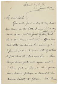
[ENSLAVEMENT & ABOLITION]. Letter from a southern slave trader describing the transportation ofFreeman's | Hindman4.4(1.6k)See Sold PriceFeb 27, 2024
Carey, pub. 1796 - Map of The State of South CarolinaTrillium Antique Prints & Rare Books4.5(30)See Sold PriceFeb 24, 2024
Carey, pub. 1796 - Map of the Tennassee State formerly part of North Carolina (Tennessee)Trillium Antique Prints & Rare Books4.5(30)See Sold PriceFeb 24, 2024
Map: An 18thC engraved and hand coloured map of North America and South America, titled DeClaydon Auctioneers Ltd4.3(125)See Sold PriceFeb 26, 2024
1822 MAP of NORTH & SOUTH AMERICA GEOGRAPHICAL STATISTICAL HISTORICAL antiqueJasper524.5(9.8k)See Sold PriceFeb 27, 2024
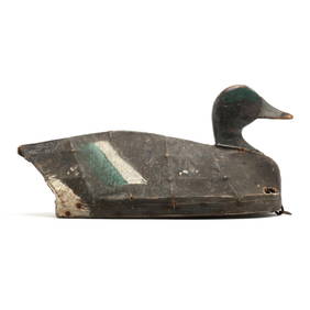
Ned Burgess (NC, 1868-1958), Important Published Widgeon, Mose White RigLeland Little4.5(697)See Sold PriceFeb 29, 2024
Blackie (Pub) 1882 Pair of Folio Maps. Italy - North & SouthAlbion Auctions4.6(341)See Sold PriceMar 01, 2024
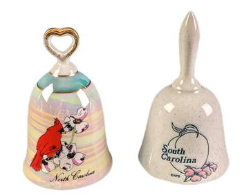
Vintage North And South Carolina Souvenir Porcelain BellsRapid Estate Liquidators and Auction Gallery4.5(1.1k)See Sold PriceMar 02, 2024


![[ENSLAVEMENT & ABOLITION]. Letter from a southern slave trader describing the transportation of (1 of 3)](https://p1.liveauctioneers.com/197/319238/171468031_1_x.jpg?height=282&quality=70&version=1707520367)