John Tallis The World on Mercator's ProjectionShowing the voyages of Captain Cook around the world, c1851 22" x 18 1/2"See Sold Price
SoldTallis: Map of The World on Mercator's Projection, 1853The World on Mercator's Projection. Original lithograph by John Tallis & Company of London, c. 1853. Map vignettes feature Vesuvius, London, Gibraltar, Constantinople, the Pyramids of 'Ghizeh' (Giza),See Sold Price
Sold[TALLIS, JOHN] A lot of 9 maps by John Tallis & Co[TALLIS, JOHN] A lot of 9 maps by John Tallis & Co. London / New York, ca. 1840. Approx. 20 x 30 each. Includes:Eastern Hemisphere ** Central America ** The World on Mercators Projection Shewing The VSee Sold Price
Map of The World by TallisHand coloured. "On Mercator's Projection". From The Illustrated Atlas, And Modern History Of The World Geographical, Political, Commercial & Statistical c. 1851, published by John Tallis and Company USee Sold Price
1851 Tallis World Map, Mercator's ProjectionItem: 1851 Tallis World Map, Mercator's Projection Description: This is a decorative and striking steel engraved world map that was produced from the same plate used to celebrate the explorations by CSee Sold Price
Tallis: The World On Mercators Projection, 1851Map: The World On Mercators Projection Maker: J. Tallis and J. Rapkin Date: 1851 Size: Quarto, 9.6 inches high x 13 inches wide "Showing the voyages of Captain Cook round the world." Sandwich IslandsSee Sold Price
Tallis World Map World on Mercator's Projection 1851Tallis World Map The World on Mercator's Projection 1851. T. Jefferys, 1757 London, 6 X 10.6 In.. This Is an Attractive and Charming Double Hemisphere Map, Colored, and Framed. it Is Set Against a BacSee Sold Price
SoldTallis (J) The World of Mercator's ProjectionTallis (J) The World of Mercator's Projectionwith vignette views and decorative borders, the second mentioned in spherical form with ornate border, 4 engraved maps, with partial original hand-See Sold Price
SoldTallis World Map World on Mercator's Projection 1851Tallis World Map The World on Mercator's Projection 1851 . J. Tallis, 1851 London, 10.5 X 14 In.. This Is a Decorative and Striking Steel Engraved World Map That Was Produced from the Same Plate UsedSee Sold Price
SoldRapkin, John 1860 Map. World on Mercator's ProjectionSteel Engraved Map Published 1860 by The London Printing & Published Company, London for "The Royal Dictionary-Cyclopedia for Universal Reference" by Thomas Wright. Drawn & Engraved by John Rapkin. FoSee Sold Price
SoldRapkin, John 1860 Map. World on Mercator's ProjectionSteel Engraved Map Published 1860 by The London Printing & Published Company, London for "The Royal Dictionary-Cyclopedia for Universal Reference" by Thomas Wright. Drawn & Engraved by John Rapkin. FoSee Sold Price
SoldMap World of Mercator's Projection John TallesMap World of Mercator's Projection John Talles - drawn & engraved by J. RapkinSee Sold Price
SoldWorld.- Purdy (John, hydrographer) A Chart of theWorld.- Purdy (John) A Chart of the World, on Mercator's Projection; with the Tracks of the more Distinguished Modern Navigators. Regulated throughout, according to the best Scientific Determinations,See Sold Price
The World on Mercator's Projection by John Bartholomew 1859 old antique mapCAPTION PRINTED BELOW PICTURE: 'The World on Mercator's Projection' Small fragments of the Antarctic coast are shown. The antipodes are named as "New Holland or Australia", while the islands of New ZeSee Sold Price
The World on Mercator's Projection by John Dower 1845 old antique map chartTITLE/CONTENT OF MAP: 'The World on Mercator's Projection' DATE PRINTED: 1845 IMAGE SIZE: Approx 22.0 x 27.5cm, 8.75 x 10.75 inches (Medium) TYPE: Antique map with original hand colouring CONDITION: FSee Sold Price
World on Mercator's Projection by John Dower. British Empire in pink 1876 mapTITLE/CONTENT OF MAP: 'The World on Mercator's Projection By John Dower F.R.G.S. N.B. British Possessions are colored red' DATE PRINTED: 1876 IMAGE SIZE: Approx 34.5 x 52.0cm, 13.5 x 20.5 inches (LargSee Sold Price
SoldA Geographical Description of the World[..Intended as an Accompaniment to the Map of the World on Mercator's Projection], by John Melish, (Scottish, 1771-1822), Philadelphia: published John Melish, 1818, with three folding maps (complete),See Sold Price
SoldWorld.- Bartholomew & Son Ltd. (John) Bartholomew'sWorld.- Bartholomew & Son Ltd. (John) Bartholomew's Library Chart of the World on Mercator's Projection, large map of the World on eight folding sheets, not joined, decorated with foliate borders, andSee Sold Price
Sold[Map] The World on Mercator's Projection Shewing the[Map] Tallis, J. and J. Rapkin. The World on Mercators Projection Shewing the Voyages of Captain Cook Round the World. [London, 1851]. Hand colored with a decorative border and vignettes showing the 3See Sold Price
Pinkerton: The World on Mercators Projection, 1818Map: The World on Mercators Projection, 2 sheets Maker: John Pinkerton Date: c. 1818 Medium: Copperplate engraving Description: Two large double folio sheets comprising a world map on Mercator's ProjeSee Sold Price
World on Mercator's Projection.Reserve Reduced! Title/Content of Map: World on Mercator's Projection. Date: 1822 Cartographer: John Purdy Material/Medium: R.H. Laurie Size: 11.75Height - 18.6Width Published by R.H. Laurie No. 53 FlSee Sold Price
Sold(WORLD.) Teesdale, Henry; and Dower, John (engraver). A(WORLD.) Teesdale, Henry; and Dower, John (engraver). A New Chart of the World on Mercator's Projection with the Tracks of the Most Celebrated & Recent Navigators. Large engraved map of the world showSee Sold Price
SoldUntitled. [the World On Mercator's Projection]Title/Content of Map: Untitled. [the World On Mercator's Projection] Date Printed: 1920 ca. Cartographer: BARTHOLOMEW, JOHN & SON Size: 49.75x73 Full color gauze back dissected folding map. Folds intoSee Sold Price
SoldARROWSMITH, JOHN; and EDWARD STANFORD. A Chart of theARROWSMITH, JOHN; and EDWARD STANFORD. A Chart of the World on Mercator's Projection Shewing the Principal Ocean Steam Routes, the Submarine Telegraph, &c. Large engraved case map of the world with deSee Sold Price
Blue & White Chinese Porcelain around the World by John CarswellSunburst Auction4.4(21)See Sold PriceFeb 24, 2024
Set of 10 books: 1949 Printing of Don Quixote, Abraham Lincoln by Emil Ludwig, The Third RoseCain Modern Auctions4.4(45)See Sold PriceFeb 28, 2024
De Passe. Portraits. To include: Gerard Mercator, Nicolaus Paschasius, John More, Philip Herbert,Tremont Auctions4.5(297)See Sold PriceFeb 25, 2024
The First World War by John Keegan 2001 New ConditionNorth American Artifact Auctions4.7(198)See Sold PriceApr 20, 2024
Michael Jackson Photograph Print By John RowlandsShakespeare Auctions4.3(1)See Sold PriceFeb 25, 2024
Leonard Cohen 'At The Door' Photographic Print By John RowlandsShakespeare Auctions4.3(1)See Sold PriceFeb 25, 2024
Arrowsmith & Lewis - Map of the World on Mercator's ProjectionTrillium Antique Prints & Rare Books4.5(32)See Sold PriceFeb 24, 2024
De Jode, Rare, pub. 1593 - Map of Africa (Africae Vera Forma, et Situs)Trillium Antique Prints & Rare Books4.5(32)See Sold PriceFeb 24, 2024
THE NEW WORLD (2005) - John Smith's (Colin Farrell) Production-Made FeatherPropstore4.2(6)See Sold PriceMar 14, 2024
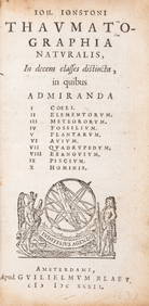
Natural world.- Geology.- Jonston (John) Thaumatographia naturalis, in decem classes distincta,Forum Auctions4.3(53)See Sold PriceFeb 29, 2024
NORTHERN AFRICA. Morocco Tunisia Algeria. Caravan routes. RAPKIN/TALLIS 1851 mapJasper524.5(9.9k)See Sold PriceFeb 28, 2024
NORTHERN AFRICA. Morocco Tunisia Algeria. Caravan routes.TALLIS/RAPKIN 1851 mapJasper524.5(9.9k)See Sold PriceFeb 28, 2024
NORTHERN AFRICA. Morocco Tunisia Algeria. Caravan routes. RAPKIN/TALLIS 1851 mapJasper524.5(9.9k)See Sold PriceFeb 28, 2024
Blackie (Pub) 1882 Folio Map. World on Mercators ProjectionAlbion Auctions4.7(341)See Sold PriceMar 01, 2024
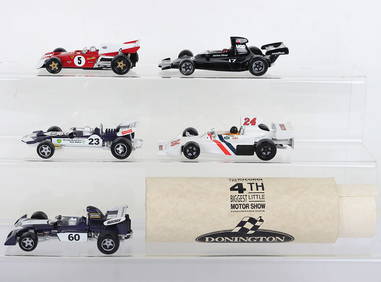
Corgi Classics Prototypes of Five Donington Collection Racing CarsC & T Auctioneers and Valuers Ltd4.3(56)See Sold PriceJul 13, 2024


![[TALLIS, JOHN] A lot of 9 maps by John Tallis & Co (1 of 1)](https://p1.liveauctioneers.com/1124/187577/94368895_1_x.jpg?height=282&quality=70&version=1607095126)


![[Map] The World on Mercator's Projection Shewing the (1 of 1)](https://p1.liveauctioneers.com/928/150426/75971118_1_x.jpg?height=282&quality=70&version=1568819120)


![Untitled. [the World On Mercator's Projection] (1 of 2)](https://p1.liveauctioneers.com/5584/120869/61529702_1_x.jpg?height=282&quality=70&version=1524613752)