SoldJohn Speede Map of Anglesey, 15 x 20 ins.John Speede coloured engraving, Map of Anglesey, 15 x 20 ins.See Sold Price
SoldJohn Norden Map of Sussex, 15 x 20 ins.John Norden coloured engraving, Map of Sussex, 15 x 20 ins.See Sold Price
SoldJohn Speed Map of Rutlandshire, 15 x 20 ins.John Speed coloured engraving, Map of Rutlandshire, 15 x 20 ins.See Sold Price
SoldJohn Speede The Countye of Monmouth, 15 x 20 ins.John Speede coloured engraving, The Countye of Monmouth, 15 x 20 ins.See Sold Price
JOHN SPEED MAP OF ANGLESEY AND IRISH SEA.JOHN SPEED MAP OF ANGLESEY AND IRISH SEA. 15" x 20"See Sold Price
SoldJohn Speede (1552-1629) British. "York Shire", Map, 15"John Speede (1552-1629) British. "York Shire", Map, 15" x 20".See Sold Price
SoldAfter John Speede (1552-1629) British. "Sussex", Map,After John Speede (1552-1629) British. "Sussex", Map, 15.5" x 20.5", together with a Map of 'Roads of Great Britain', two (2).See Sold Price
SoldJohn Speede (1552-1629) British. "The Province Ulster",John Speede (1552-1629) British. "The Province Ulster", Map, 15" x 20".See Sold Price
SoldJohn Speede Surrey described and divided, 15 x 20John Speede coloured engraving, Surrey described and divided, 15 x 20 ins.See Sold Price
SoldJohn Speede (1552-1629) British. "Canaan", Coloured MapJohn Speede (1552-1629) British. "Canaan", Coloured Map c.1611, 15" x 20".See Sold Price
SoldJohn Speede (1552-1629) British. "A New Mappe of TheJohn Speede (1552-1629) British. "A New Mappe of The Romane Empire", Map, 15.5" x 20".See Sold Price
SoldJohn Speede (1552-1629) British. "The Kingdome ofJohn Speede (1552-1629) British. "The Kingdome of China", Map, 15.25" x 20".See Sold Price
SoldJohn Speede (1552-1629) British. "France c.1626", withJohn Speede (1552-1629) British. "France c.1626", with Parts of England and Germany, Map, 15.5" x 20.25".See Sold Price
SoldJohn Speed Map of Jamaica and Barbados, 15 x 20 iJohn Speed unframed coloured engraving, Map of Jamaica and Barbados, 1676, 15 x 20 ins.See Sold Price
SoldJohn Speede (1552-1629) British. "A Newe Mape ofJohn Speede (1552-1629) British. "A Newe Mape of Tartary", Map, 15.25" x 20".See Sold Price
SoldJohn Speede (1552-1629) British. "The Countye PalatineJohn Speede (1552-1629) British. "The Countye Palatine of Chester", Map, Unframed, 15" x 20".See Sold Price
SoldJohn Wolfe Map of Arabia and India, 15 x 20.5 insJohn Wolfe coloured engraving, Map of Arabia and India, 15 x 20.5 ins.See Sold Price
SoldJohn Speede (1552-1629) British. "Shropshyre" [sic],John Speede (1552-1629) British. "Shropshyre" [sic], Coloured Map, Unframed, 15.25" x 20".See Sold Price
SoldJohn SPEEDE (1552-1629) MapArtist: John SPEEDE (1552-1629). Title: Hand colored "DENBIGH SHIRE" map. Size: 15 1/2 x 20 1/2 in. Frame: 22 1/2 x 27 1/2 in. Condition: Good, lite toning to paper. Created: 1610. Medium: Hand coloreSee Sold Price
SoldTwo Early John Speede MapsThe Kingdome of Persia with the cheef citties and habites described. Sheet size: 22" x 17 1/2" Plate impression visible. Plate size: 20 1/2" x 15 3/4". Hand colored on laid paper.See Sold Price
SoldA coloured and tinted map of Anglesey by JOHN SPEA coloured and tinted map of Anglesey by JOHN SPEED, Sudbury & Humbell edition, 15 x 20See Sold Price
SoldA coloured and tinted map of Anglesey by JOHN SPEA coloured and tinted map of Anglesey by JOHN SPEED, Bassett & Chiswell edition, 15 x 20See Sold Price
Sold18th C. Engraved Map of "Anglesey"18th century, engraved map of "Anglesey", by John Speed, 15 1/2"h x 20 1/2"w (sight).See Sold Price
SoldJOHN SPEEDE (BRITISH 1552 - 1629) A HAND COLOREDJOHN SPEEDE (BRITISH 1552 - 1629) A HAND COLORED ENGRAVED MAP, "SURREY DESCRIBED AND DIVIDED 1610." 15" x 20"See Sold Price
RARE 1638 HONDIUS MAP OF BERMUDA, FRAMEDThomaston Place Auction Galleries4.4(393)See Sold PriceFeb 24, 2024
17TH C. MAP OF THE BERKSHIRES BY JOHN SPEED, FRAMEDThomaston Place Auction Galleries4.4(393)See Sold PriceFeb 24, 2024
MID CENTURY MODERN REVERSE PAINTING on GLASSJohn McInnis Auctioneers,LLC4.5(505)See Sold PriceFeb 25, 2024
Vintage Full Color World Map LithographThe Benefit Shop Foundation Inc.4.3(2.9k)See Sold PriceFeb 28, 2024
Willem Blaeu, Etc. 17th C. Antiquarian Maps, 2Auctions at Showplace4.6(740)See Sold PriceMar 17, 2024
Map: A 17thC engraved map of the British Isles titled A Generall Mapp of the Isles of GreatClaydon Auctioneers Ltd4.3(125)See Sold PriceFeb 26, 2024
Andre Masson pochoir. 1929, from the portfolio Dix reproductionsTheRedFinch Auctions4.4(24)See Sold PriceFeb 29, 2024
Georges Roualt pochoir. 1932, from the portfolio Dix reproductionsTheRedFinch Auctions4.4(24)See Sold PriceFeb 29, 2024
Juan Gris - Le Paquet de tabac, 1933 after 1914 Juan Gris 's "papier colle"NCAG4.4(33)See Sold PriceMar 10, 2024
JOHN CUTHBERT HARE (Massachusetts/Florida, 1908-1978), Portrait of a fisherman., Charcoal on paper,Eldred's4.7(419)See Sold PriceMar 07, 2024
Colonial Africa North-West. British French. Nigeria Sahara. THE TIMES 1900 mapJasper524.5(9.9k)See Sold PriceFeb 28, 2024
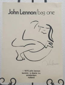
John Lennon Bag One Complete Set LithographsLegacy Auctions & Estate Sales4.6(72)See Sold PriceFeb 29, 2024
John Cooke 1800s Engraving View of Plymouth Fort & St Nicholas Island FRAMEDKCM Galleries4.7(164)See Sold PriceFeb 25, 2024
Godward - Landscape Blossoming Red Almond StudyFederal Assets Auctioneers4.4(412)See Sold PriceFeb 26, 2024


![John Speede (1552-1629) British. "Shropshyre" [sic], (1 of 3)](https://p1.liveauctioneers.com/421/99103/50512329_1_x.jpg?height=282&quality=70&version=1484673277)