SoldJohn Speed Map of Great BritainEnglish, 17th century, "The Kingdome [sic] of Great Britaine and Ireland," by John Speed, engraved by J. Hondius, printed by Sudbury and Humble, London, 1610, with elaborate cartouches and insets of LSee Sold Price
SoldTwo John Speed Maps of Britainetching with hand coloring, both from Bassett & Chiswell edition of [Theatre of Empire of Great Britain]; [Devonshire with Excester Described...] and [Glocestershire...], etching with handcoloring; frSee Sold Price
SoldSpeed (John) Britain as it was Devided in the tymeSpeed (John) Britain as it was Devided in the tyme of the Englishe Saxons,map of Great Britain, strapwork cartouche containing title, inset coats of arms and 2 panels depicting Saxon leaders sSee Sold Price
SoldJohn Speed's Celebrated 17th Century Map of theun-colored copperplate engraving, A New Description of Carolina (London: Thomas Basset and Richard Chiswell,1676), engraved by Francis Lamb, from The Theatre of the Empire of Great Britain, depictingSee Sold Price
Sold2 Maps. Oxfordshire and Scotia Regnum.[Great Britain] 2 Maps. Hole, William. "Scotia Regnum." c. 1610. Engraved map. Hand colored. Image: 12 1/4" x 10 1/4". Framed: 19 1/2" x 17 1/2". ++ Speed, John. "Oxfordshire described with ye Citie aSee Sold Price
SoldJodocus Hondius (Flemish 1563-1611)/The Countie andJodocus Hondius (Flemish 1563-1611)/The Countie and Citie of Lyncolne from John Speed's Theatre of the Empire of Great Britain/hand coloured engraved map, 38.5cm x 51.5cmSee Sold Price
SoldSpeed Map of CarolinaSPEED, John (1551/52-1629).A New Description of Carolina...Engraved map, as published in the original uncolored state.London, 1676, from John Speed's The Theatre of the Empire of Great Britain.15" X 2See Sold Price
SoldSpeed (John) OxfordshireSpeed (John) Oxfordshire described with ye Citie and the Armes of the Colledges of yt famous University, hand-coloured engraving, from the Theatre of the Empire of Great Britain, English text verso, cSee Sold Price
SoldSpeed (John) - The Kingdome of Great Britaine andmap of Britain and Ireland with part of the coast of Flanders and Holland, inset map of the Orkneys, and inset views of London and Edinburgh, ships and sea monsters, engraved with hand-colouring, 390See Sold Price
SoldSpeed (John) - The Kingdome of Great Britaine andmap of Britain and Ireland with part of the coast of Flanders and Holland, inset map of the Orkneys, and inset views of London and Edinburgh, ships and sea monsters, engraved with hand-colouring, 390See Sold Price
SoldTwo Early Framed Engraved MapsA lot of two early hand-colored engraved maps to include a W. J. Bleau map of Amsterdam, ca. 1634-1635, "Sabaudia Ducatus Savoye", together with a John Speed map of Britain, ca. 1611-1614, "DevonshireSee Sold Price
SoldJohn Speed's History fo Great Britain 1623Heading: Author: Speed, John Title: The Historie of Great Britaine Under the Conquests of the Romans, Saxons, Danes and Normans. Their Originals, Manners, Habits, Warres, Coines, and Seales: With theSee Sold Price
SoldJohn Speed's History of Great Britain 1650Heading: Author: Speed, John Title: The History of Great Britaine Under the Conquests of ye Romans, Saxons, Danes and Normans Place Published: London Publisher:George Humble Date Published:See Sold Price
SoldSpeed (John) Great Britain 1623Speed (John) The History of Great Britain under the Conquests under ye Romans, Saxons, Danes and Normans, second edition, engraved title within ornate architectural border, engraved illustratrSee Sold Price
SoldSenex (John) - A New Map of Great Britain,with inset map of the Orkney and Shetland Islands, and decorative title and dedication cartouches, engraved map with original hand-colouring, 650 x 960mm., on two sheets, joined, a few repairs to horiSee Sold Price
SoldBBRI Senex (John) A New Map of Great BritainBBRI Senex (John) A New Map of Great Britain,with inset map of the Orkney and Shetland Islands, and decorative title and dedication cartouches, engraving with hand-colouring, on two sheets joiSee Sold Price
SoldSenex (John) A New Map of Great BritainSenex (John) A New Map of Great Britainwith inset map of the Orkney and Shetland Islands, and decorative title and dedication cartouches, engraved map with original hand-colouring, on two sheeSee Sold Price
SoldSenex (John) A New Map of Great BritainSenex (John) A New Map of Great Britain,with inset map of the Orkney and Shetland Islands, and decorative title and dedication cartouches, engraved map with original hand-colouring, on two sheSee Sold Price
SoldHand colored engraved map, John Speed, BritainFramed hand colored copper engraved map, ""Britain as it was Divided in the time of the English Saxons,"" by John Speed (British,1552-1629), image: 15""h x 20""w, overall: 26""h x 31""wSee Sold Price
SoldJohn Speed English 1552-1629) Antique Map Of BritainFramed antique map of Britain, drawn by John Speed, circa 1616. John Speed was an English cartographer and historian. He is, alongside Christopher Saxton, one of the best known English mapmakers of thSee Sold Price
Sold[Britain]. John Senex. A New Map Of Great Britain[Britain]. A New Map Of Great Britain: Corrected From The Observations Communicated To The Royal Society At London. John Senez. [1714]. 36 1/2 x 25 in. Very good, with normal edgewear, minor tearing aSee Sold Price
Sold(Map, Great Britain), Ogilby, John (1600-1676), Th(Map, Great Britain), Ogilby, John (1600-1676), The Road from London to Boston, hand-colored strip map, framed with verre eglomise mat, sight size 17 5/8 x 13 3/8 in. (450 x 340 mm), (minor handling cSee Sold Price
Fine Senex Map of Great BritainSenex, John (1678-1740) New Map of Great Britain... T. Bowles, 1752. Engraved map. 36 ½" x 25" sheet. "...corrected from the observations communicated to the Royal Society at London by John Senex,See Sold Price
SoldSpeed (John) The History of Great Britain under thSpeed (John) The History of Great Britain under the Conquests under ye Romans, Saxons, Danes and Normans,second edition, engraved title within ornate architectural border, engraved illustratioSee Sold Price
General Books - Nicolson - The Counties of Britain - A Tudor Atlas by John SpeedTimeLine Auctions Ltd.4.6(183)See Sold PriceMar 08, 2024
General Books - Four Maps of Great Britain Designed by Matthew Paris About A.D. 1250TimeLine Auctions Ltd.4.6(183)See Sold PriceMar 08, 2024
Industry Shall Be Rewarded Rare Electroplated Beehive BankThe RSL Auction Company4.6(240)See Sold PriceMar 09, 2024
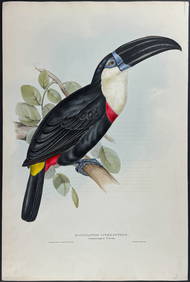
Gould - Natterer's Aracari or ToucanTrillium Antique Prints & Rare Books4.5(32)See Sold PriceFeb 24, 2024
2pc David Winter Figure Woodcutter Cottage & Collector BookLion and Unicorn4.8(1.9k)See Sold PriceMar 10, 2024


![[Britain]. John Senex. A New Map Of Great Britain (1 of 1)](https://p1.liveauctioneers.com/179/1435/617485_1_x.jpg?height=282&quality=70)