SoldJohn Speed Hand-Colored Map 17thC DevonshireJohn Speed hand-colored map, 1611-1646, "Devonshire with Excester Described and the armes of such nobles as have borne the titles of them", 16" x 21". Good condition.See Sold Price
Sold17THC MAP/NORTHAMPTONSHIRE,HANDCOLORED,JOHN SPEED17THC MAP OF NORTHAMPTONSHIRE, HAND COLORED, JOHN SPEED, 21" X 25 1/2", SOME LOSSES AT EDGES, VERTICAL CREASE DOWN CENTER, UNFRAMED.See Sold Price
SoldSPEED, JOHN. Devonshire.SPEED, JOHN. Devonshire. Double-page engraved map, 385x515 mm, wide margins, English text on verso; nicely hand-colored and in outline; matted. London: Bassett and Chiswell, [1676] All items are offerSee Sold Price
SoldAntique John Speed Hand-Colored Map of WilshireAn antique hand colored John Speed map of Wilshire with illustrated "Armes of the Earles of Wilshire and Salesburye", inset map of Salesbury, and inset of Stonehenge. 2 pages (25 and 26) of history onSee Sold Price
SoldJohn Speed Hand-Colored Map of Russia, C1627John Speed (London) circa 1627 hand-colored map, "A Map of Russia Sold by Tho. Basset in Fleetstreet and Richard Chiswell in St. Paul's Church yard", 40.6 x 53.3cm, 16"h. x 21"w., in frame 20" x 24".See Sold Price
Sold1610-1676 John Speed Hand Colored Map1610-1676 John Speed hand colored 21 1/4" x 16 1/2" Map, "Norfolk, A Countie Flourishing & Populous Described and Divided with the Arms of Such Noble Families As Have Borne The Titles Thereof", From SSee Sold Price
Sold17th Century Map of Turkish EmpireJohn Speed. Hand-colored map of the Turkish Empire, dated 1626. 16" x 20-1/2".See Sold Price
SoldOriginal John Speed Map 1610 of LondonOriginal John Speed Hand Colored Map of Middlesex London and Westminster. Dated 1610. Map is in excellent condition for something it's age, with only a few fold lines and creases. Professionally mountSee Sold Price
SoldOriginal John Speed Map 1610 of LondonOriginal John Speed Hand Colored Map of Middlesex London and Westminster. Dated 1610. Map is in excellent condition for something it's age, with only a few fold lines and creases. Professionally mountSee Sold Price
SoldOriginal John Speed Map 1610 of LondonOriginal John Speed Hand Colored Map of Middlesex London and Westminster. Dated 1610. Map is in excellent condition for something it's age, with only a few fold lines and creases. Professionally mountSee Sold Price
SoldOriginal John Speed Map 1610 of LondonOriginal John Speed Hand Colored Map of Middlesex London and Westminster. Dated 1610. Map is in excellent condition for something it's age, with only a few fold lines and creases. Professionally mountSee Sold Price
SoldOriginal John Speed Map 1610 of LondonOriginal John Speed Hand Colored Map of Middlesex London and Westminster. Dated 1610. Map is in excellent condition for something it's age, with only a few fold lines and creases. Professionally mountSee Sold Price
SoldOriginal John Speed Map 1610 of LondonOriginal John Speed Hand Colored Map of Middlesex London and Westminster. Dated 1610. Map is in excellent condition for something it's age, with only a few fold lines and creases. Professionally mountSee Sold Price
SoldAntique John Speed Hand Colored Lancaster MapAntique John Speed Hand Colored "The Countie Pallatine of Lancaster Described and Divided Into Hundreds 1610" Map. The map features the portraits of Henry IIII, Henry V, Henry VI, and Henry VII underSee Sold Price
SoldFramed Map Isle of Mad Speed & DurhamFramed map The Isle of Man, described by Tho Durham, Ano. 1595, performed by John Speed 1610, hand colored, map based on actual survey by Thomas Durham. The dispute over possession of the Island is ilSee Sold Price
SoldJohn Speed (1552-1629), hand colored engraved map ofJohn Speed (1552-1629), hand colored engraved map of America 1626, "America with those known parts in that unknown worlde both people and manner of buildings described enlarged by I S An 1626" platSee Sold Price
John Speed (England, 1552-1629), two hand-colored mapsJohn Speed (England, 1552-1629), two hand-colored maps on paper: one of Northumberland with town planning, royal arms, and Roman sculptures, plate mark visible on top edge; the other a map of ShropshiSee Sold Price
Sold1626-Dated JOHN SPEED Map of America CA an IslandHistoric Maps 1626 "America with those known Parts in that unknown Worlde..." Hand-Colored Engraved Map by John Speed 1626-Dated, Hand-Colored Engraved Map titled, "America with those known Parts in tSee Sold Price
SoldENGRAVED HAND-COLORED MAP Speed, John. NorthumberENGRAVED HAND-COLORED MAP Speed, John. Northumberland." 15 x 20 in.; 380 x 508mm. Margins. Some dust soiling, occasional dampstaining."See Sold Price
SoldEngraved Hand-Colored Maps: Speed, John.Engraved Hand-Colored Maps: Speed, John. "Wales." 1630. 15 1/4 x 20 1/2 inches; 394 x 520 mm. Trimmed within plate mark, chipped along edges, rather browned, repairs to verso. S.w.a.f. * De Vaugondy,See Sold Price
c1676 Handcolored JOHN SPEED Map New England + NYHistoric Maps c. 1676 Hand-Colored Copper Plate Engraved Map titled "A Map of New England and New York" by John Speed c. 1676, Original Hand-Colored, Classic Copper Plate Engraved Map titled, "A Map oSee Sold Price
c.1676 Handcolored JOHN SPEED Map New England, NYHistoric Maps c. 1676 John Speed "A Map of New England and New York" Hand-Colored Copper Plate Decorative Engraved Map c. 1676, Original Hand-Colored, Classic Copper Plate Engraved Map titled, "A MapSee Sold Price
SoldSPEED, JOHN. Asia.SPEED, JOHN. Asia. Hand-colored engraved miniature map of Asia engraved by Pieter van den Keere. 4x7 inches sheet size, English text on verso; small desiccated tape stains at upper edge. - London, cirSee Sold Price
SoldEarly Hondius Hand Colored Map "Northamtonshire"Early Hondius hand colored map by John Speed (English, 1552-1620), "Northamtonshire". Framed, not examined out of frame. Sight size: 15" high, 20" wide. Frame size: 21" high, 26" wide. Condition: toniSee Sold Price
17TH C. ENGLISH LINEAR MAP BY OGILBY, FRAMEDThomaston Place Auction Galleries4.4(393)See Sold PriceFeb 24, 2024
Hand Colored Map of the city of Amsterdam 1720Global Auctions Company4.3(36)See Sold PriceMar 03, 2024
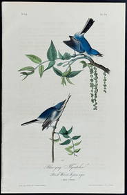
Audubon - Blue-grey Flycatcher. 70Trillium Antique Prints & Rare Books4.5(32)See Sold PriceFeb 24, 2024
Audubon - Fork-tailed Flycatcher. 52Trillium Antique Prints & Rare Books4.5(32)See Sold PriceFeb 24, 2024
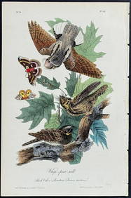
Audubon - Chuck-will's Widow. 41Trillium Antique Prints & Rare Books4.5(32)See Sold PriceFeb 24, 2024
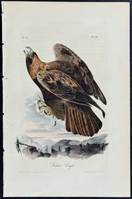
Audubon - Common Osprey Fish Hawk. 15Trillium Antique Prints & Rare Books4.5(32)See Sold PriceFeb 24, 2024
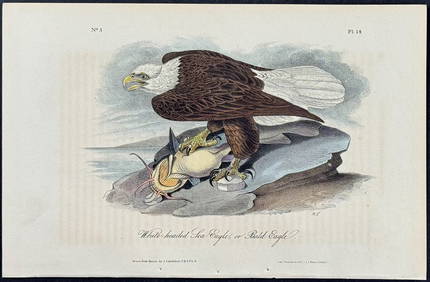
Audubon - White-headed Sea Eagle or Bald Eagle. 14Trillium Antique Prints & Rare Books4.5(32)See Sold PriceFeb 24, 2024
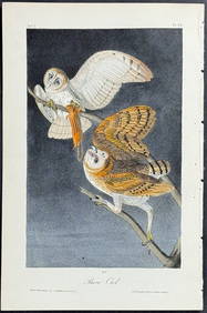
Audubon - Little Screech Owl. 40Trillium Antique Prints & Rare Books4.5(32)See Sold PriceFeb 24, 2024
Map: An engraved and hand coloured map titled The Countie of Nottingham described The Shire TownesClaydon Auctioneers Ltd4.3(125)See Sold PriceFeb 26, 2024