SoldJohn Rocque, Large 2 Sheet Map, 1780John Rocque (1709-1762) , "England and Wales, Drawn from the most accurate Surveys...", large two-sheet map from Sayer's "General Atlas", 1780, engraved, with outline color, elaborate cartouche, combiSee Sold Price
SoldJohn Rocque, Map of Ireland, Engraved, 1780John Rocque (1709-1762) , "A Map of the Kingdom of Ireland, divided into provinces, counties...", large two-sheet map from Sayer's "General Atlas", 1780, engraved with outline color, elaborate cartoucSee Sold Price
SoldRocque, John108. Rocque, John.A Map of the Kingdom of Ireland. Large engraved map of Ireland on 2 sheets. 48 x 38 inches, plus margins, outlined in color; margins frayed, several closed tears along folds, generalSee Sold Price
SoldHalley (Capt. Edmund) - A New and Correct Sea Chart ofreduced version of Halley's large 2-sheet map by Mount and Page, advertised in lower left corner, with adjacent inset of the North Pole, title cartouche upper left, engraved chart by John Harris, on 2See Sold Price
SoldIreland.- Rocque (John) - A Map of the Kingdom oflarge 4-sheet map with title vignette of watering cattle and river nymph, upper left, inset map of the Sea Coasts of Great Britain and Ireland, lower right, text panels and compass rose, engraved mapSee Sold Price
SoldLarge map: John Rocque, England and Wales, 1794.[Britain]. John Rocque. England And Wales Drawn From The Most Accurate Surveys Containing all the Cities, Boroughs, Market Towns... Engraved 4-sheet map joined to form to sections. Lon: Laurie & WhittSee Sold Price
SoldChurchman (John) The Magnetic Atlas,1794Churchman (John) The Magnetic Atlas, or variation charts of the whole terraqueous globe..., 2 engraved figures on one folding sheet, 2 large folding engraved maps hand-coloured in outline, lisSee Sold Price
SoldIndia - Walker, John, mapmaker to the East IndiaIndia - Walker, John, mapmaker to the East India Company Map of India, shewing the British London: Wm. H. Allen, 1853. Large, folded linen-backed map in 2 sheets, each sheet 87.5 x 168.2cm and dividedSee Sold Price
India - Walker, John, mapmaker to the East IndiaLondon: Wm. H. Allen, 1853. Large, folded linen-backed map in 2 sheets, each sheet 87.5 x 168.2cm and divided into sections, folding into a contemporary brown cloth gilt case, the map hand-coloured wiSee Sold Price
SoldSenex (John) Denmark; Sweden; GermanySenex (John) Denmark; Sweden; Germany, together 3 engraved maps, each 2 sheets joined, with original hand-colouring, large decorative cartouches, Denmark (uncoloured), 665 x 970mm., some brownSee Sold Price
SoldLondon.- Richmond.- Rocque (John) [A New Plan ofLondon.- Richmond.- Rocque (John) [A New Plan of Richmond Garden], one sheet only (of 2), with part plan of the park along the Thames, with 11 inset views of the royal houses and related pleasure builSee Sold Price
SoldRocque (John) A Map of the Kingdom of Ireland-. Rocque (John) A Map of the Kingdom of Ireland, large map of Ireland, on 4 sheets, joined, with original hand-colouring, large pictorial cartouche, inset map of the coasts of Great Britain aSee Sold Price
Senex (John) North America Corrected from the ObseSenex (John) North America Corrected from the Observations Communicated ...,large decorative title cartouche upper left, engraved map with outline hand-colouring, on 2 sheets, joined, 940 x 65See Sold Price
SoldLow Countries.- Senex (John) - The VII Unitedthe Low Countries with large decorative title cartouche of Neptune, mermen seahorses and herons, upper left, engraved map with original hand-colouring in outline, on 2 sheets, joined, 650 x 950mm., olSee Sold Price
SoldSenex (John) Sweden; DenmarkSenex (John) Sweden; Denmarkthe former showing the whole of Scandinavia, both with large decorative cartouches, 2 engraved maps with original hand-colouring in outline, both on two sheets joinSee Sold Price
Pinkerton: The World on Mercators Projection, 1818Map: The World on Mercators Projection, 2 sheets Maker: John Pinkerton Date: c. 1818 Medium: Copperplate engraving Description: Two large double folio sheets comprising a world map on Mercator's ProjeSee Sold Price
SoldWalker (John) Map of IndiaWalker (John) Newly constructed and extended Map of India,large map of India engraved by John Walker, in 2 parts, each on 3 sheets joined, dissected and linen backed, each part 810 x 1555mm.,See Sold Price
Sold6 Maps: Tallis, 3 Canadian fisheries, 2 Arrowsmith[Canada] 6 Maps. ++ Tallis. EAST CANADA AND NEW BRUNSWICK. John Tallis, [c. 1851-57]. Image: 8 5/8 x 11 3/4 in. Sheet: 10 5/8 x 14 1/8 in., double page. Hand-colored in outline. With a large view of QSee Sold Price
Faden (William) - A Map of France according to thelarge 2-sheet map of France with decorative vine garland cartouche lower left, engraved map with original hand-colouring in outline, 1120 x 1180mm., if joined, dissected and linen-backed, slight browSee Sold Price
SoldFER, NICOLAS de. La Grande Riviere de Canada aFER, NICOLAS de. La Grande Riviere de Canada appellee par les Europeens de St. Laurens. Large engraved 2-sheet map joined, 605x960 mm overall; some toning, considerably browned along one fold, minor sSee Sold Price
SoldMOLL, HERMAN. A Map of the West-Indies.MOLL, HERMAN. A Map of the West-Indies. Large folding engraved 2-sheet map joined, 605x1030 mm, wide margins top and bottom, ample on the side; hand-colored in outline; few folds weak, one repaired onSee Sold Price
Sold(RAILROAD.) Northern Pacific Railroad. MemoriaWITH A LARGE FOLDING MAP BY COLTON. (RAILROAD.) Northern Pacific Railroad. Memorial of the Board of Direction of the Company [wrapper title]. Large 2-sheet hand-colored folding map by G. W. & C. B. CSee Sold Price
SoldGENERAL LAND OFFICE. Map of the United StatesGENERAL LAND OFFICE. Map of the United States and Territories, showing the extent of Public Surveys and other details. Large hand-colored lithographed 2-sheet map joined on linen, not dissected but coSee Sold Price
SoldJapanese School. large map of JapanJapanese School. very large map of Japan,Honshu island divided over 2 large sheets, with inset map of Hokkaido on one, Kyushu and Shikoku on the other, each sheet with a large title panel, andSee Sold Price
Union Pacific RR Map of the United States-1926JM Hobby Supply and Railroad Artifact Auctions4.4(127)See Sold PriceFeb 24, 2024
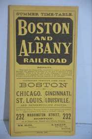
Boston and Albany RR March 17, 1881 Public TimetableJM Hobby Supply and Railroad Artifact Auctions4.4(127)See Sold PriceFeb 24, 2024
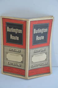
Chicago Burlington and Quincy RR November 30, 1887 Public TimetableJM Hobby Supply and Railroad Artifact Auctions4.4(127)See Sold PriceFeb 24, 2024
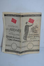
Chicago Milwaukee and St Paul RY March 1, 1889 Public TimetableJM Hobby Supply and Railroad Artifact Auctions4.4(127)See Sold PriceFeb 24, 2024
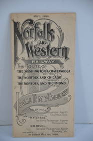
Norfolk and Western RY May 1898 Public TimetableJM Hobby Supply and Railroad Artifact Auctions4.4(127)See Sold PriceFeb 24, 2024
LATE 18TH C. VERY LARGE CHART OF NORTHEAST CANADA BY DES BARRES (1721-1824), 1780, FRAMEDThomaston Place Auction Galleries4.4(394)See Sold PriceFeb 24, 2024
Pencil Signed Large Abstract Modernist LithographEpic Auctions and Estate Sales4.6(210)See Sold PriceMar 02, 2024
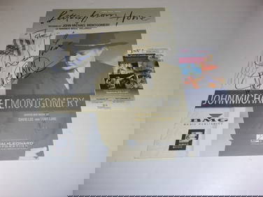
JOHN MICHAEL MONTOMERY LETTERS FROM HOME +2 AUTOS JSA/COA SIGNED SHEET MUSICMynt Auctions4.6(711)See Sold PriceFeb 24, 2024
Hand Colored Engraved Map of Europe, Jean Baptiste Bourguignon Anville 1754Global Auctions Company4.3(36)See Sold PriceMar 03, 2024
Pair of Signed John Clem Clarke Lithographs, 'Chardin: "Girl with a Racquet and Shuttlecock"'PUBLIC SALE4.7(227)See Sold PriceMar 02, 2024
San Xavier Del Bac Mission, Edward S. Curtis photogravurePBA Galleries4.7(389)See Sold PriceMar 07, 2024
JOYCE WIELAND: TRUE PATRIOT LOVE. 1971, 1st. ED.Toronto Book Auctions4.3(13)See Sold PriceMar 07, 2024
[Constructivism]. The general plan of reconstruction of Moscow. - Moscow: Moscow Worker, 1936. -ARTMAXIMUM4.3(4)See Sold PriceMar 14, 2024


![[Constructivism]. The general plan of reconstruction of Moscow. - Moscow: Moscow Worker, 1936. - (1 of 6)](https://p1.liveauctioneers.com/6171/320219/172084257_1_x.jpg?height=282&quality=70&version=1708525949)


