Archaeological Books - Roach Smith & Fairholt - The Antiquities of Richborough, Reculver, and Lymne,TimeLine Auctions Ltd.4.6(182)See Sold PriceMar 06, 2024
Archaeological Books - Akerman - Remains of Pagan SaxondomTimeLine Auctions Ltd.4.6(182)See Sold PriceMar 06, 2024
Politicians.- Collection of letters and postcards, 19th century (c. 85).Forum Auctions4.3(53)See Sold PriceFeb 29, 2024
Numismatic Books - Boyne - Tokens Issued in the Seventeenth Century in England, Wales, and IrelandTimeLine Auctions Ltd.4.6(182)See Sold PriceMar 09, 2024
SoldJohn Reid Kentucky Map, 1795Map of the State of Kentucky with the Adjoining Territories 1795 engraved by A. Anderson, published by John Reid, New York, 1796. From "The American Atlas" by John Reid, based on maps by John RussellSee Sold Price
Sold1795 Reid New York Map of Kentucky"Published by John Reid, New York"; laid down on board;15¾" tall x 19" wide.See Sold Price
Sold18 Maps of Original US States 1795Title:Eighteen bound maps of the early United States Publisher:John Reid Year:1783, 1795-96 Condition/Details:This is a fabulous collection of bound maps of the original U.S. states, printed at the enSee Sold Price
SoldMap of the State of Kentucky...John Reid & W. Winterbotham. from the American Atlas. New York: J. Reid, L. Wayland & C. Smith, 1796. Engraved Map with Original Hand-color in Outline. 16 x 19 1/2 inchesSee Sold Price
Sold1796 Tanner Map of "Tennassee"Tennessee map, A MAP OF THE TENNASSEE [sic] GOVERNMENT FROM THE LATEST SURVEYS 1795, drawn and engraved by Benjamin Tanner, published by John Reid, Levi Wayland, and Charles Smith, New York, 1796. FroSee Sold Price
SoldProvince of Maine from the best authorities, 1795.John Reid & W. Winterbotham. from the American Atlas. New York: J. Reid, L. Wayland & C. Smith, 1796. Engraved Map with Orignal Hand-color in Outline. 16 x 11 1/4 inchesSee Sold Price
Reduced Section of a General Map of North America DrawnTitle: Reduced Section of a General Map of North America Drawn from the Best Surveys 1795... Prublication Date: c1861 Cartographer: LT. WARREN'S MEMOIR PLATE I Publisher: JOHN REID /J. BIEN (LITH.) SiSee Sold Price
Sold1795 Hand-tinted Smith, Reid and Wayland Map of KY"Published by Smith, Reid and Wayland"; 15¾" x 19". Kentucky.See Sold Price
1796 John Reid Map of ConnecticutAn important map of Connecticut issued by John Reid in 1796. This map is from Reid's American Atlas, only the second atlas to be published in America..See Sold Price
JOHN REID - MAP OF NORTH AMERICA, 1796John Reid - Map Of North America, 1796 - 36 X 28 3/4 In. - This Giclée Print Is Gallery Stretched And Ready To Hang Or Lean Against A Wall, Or Display On An Easel. - A Giclée Print Is The Highest QuSee Sold Price
JOHN REID - MAP OF THE UNITED STATES OF AMERICA, 1796John Reid - Map Of The United States Of America, 1796 - 36 X 28 3/4 In. - This Giclée Print Is Gallery Stretched And Ready To Hang Or Lean Against A Wall, Or Display On An Easel. - A Giclée Print IsSee Sold Price
John Reid - Map Of North America, 1796John Reid - Map Of North America, 1796 Size: 36 X 28 3/4 In. - This Is A Gallery Stretched Giclee Print On Canvas. The Piece Was Printed On High Quality Artist Grade 350 Gsm, Acid-free, Archival CanvaSee Sold Price
John Reid - Map Of The United States Of America, 1796John Reid - Map Of The United States Of America, 1796 Size: 36 X 28 3/4 In. - This Is A Gallery Stretched Giclee Print On Canvas. The Piece Was Printed On High Quality Artist Grade 350 Gsm, Acid-free,See Sold Price
JOHN REID - MAP OF THE UNITED STATES OF AMERICA, 1796John Reid - Map Of The United States Of America, 1796 - 36 X 28 3/4 In. - Giclée Print - Gallery Stretched - Ready to hang.See Sold Price
JOHN REID - MAP OF SOUTH AMERICA, 1796JOHN REID - MAP OF SOUTH AMERICA, 1796 - 36 x 29 3/8 in. - Museum Wrapped The Piece Of Art Is Ready To Hang Or Lean Against A Wall, Or Display On An Easel. - A Giclée Print Is The Highest Quality PriSee Sold Price
JOHN REID - MAP OF SOUTH AMERICA, 1796 - GICLÉE ONJohn Reid - Map Of South America, 1796 - Giclée On Canvas 36 X 29 3/8 In. - A Giclée Print Is The Highest Quality Print Available Today. Because There Is No Visible Dot Screen Pattern, The ResultingSee Sold Price
JOHN REID - MAP OF NORTH AMERICA, 1796 - Giclée onJOHN REID - MAP OF NORTH AMERICA, 1796 - Giclée on Canvas 36 x 28 3/4 in.See Sold Price
JOHN REID - MAP OF SOUTH AMERICA, 1796John Reid - Map Of South America, 1796 - Giclée On Canvas - 36 X 29 3/8 In.~~A giclée print falls between serigraph and lithograph in quality. Although they can be made on paper, Giclees on canvas mSee Sold Price
JOHN REID - MAP OF SOUTH AMERICA, 1796John Reid - Map Of South America, 1796 - 36 X 29 3/8 In. - Giclée Print - Gallery Stretched - Ready to hang.See Sold Price
John Reid - Map Of South America, 1796John Reid - Map Of South America, 1796 Size: 36 X 29 3/8 In. - This Is A Gallery Stretched Giclee Print On Canvas. The Piece Was Printed On High Quality Artist Grade 350 Gsm, Acid-free, Archival CanvaSee Sold Price
John Reid - Map Of The West Indies, 1796John Reid - Map Of The West Indies, 1796 Size: 36 X 28 3/4 In. - This Is A Gallery Stretched Giclee Print On Canvas. The Piece Was Printed On High Quality Artist Grade 350 Gsm, Acid-free, Archival CanSee Sold Price
JOHN REID - MAP OF NORTH AMERICA, 1796John Reid - Map Of North America, 1796 - 36 X 28 3/4 In. - This Giclée Print Is Gallery Stretched And Ready To Hang Or Lean Against A Wall, Or Display On An Easel. - A Giclée Print Is The Highest QuSee Sold Price
Hammonds Map of Kentucky and Tennessee Railroads-1910JM Hobby Supply and Railroad Artifact Auctions4.4(126)See Sold PriceFeb 24, 2024
John Robertson Reid (UK,1851-1926) oil painting antiqueBroward Auction Gallery4.8(285)See Sold PriceMar 17, 2024
Early 1900's Railway Service Map, Illinois, Ohio, Indiana, Kentucky, TennesseeConnoisseur Auctions3.9(335)See Sold PriceFeb 24, 2024
John James Audubon (After) - Kentucky WarblerDane Fine Art Auctions4.4(496)See Sold PriceMar 07, 2024
John James Audubon (After) - Kentucky WarblerDane Fine Art Auctions4.4(496)See Sold PriceMar 17, 2024
[MAPS]. DUFOUR, Auguste-Henri (1795-1865). Bound Volume of ...Potter & Potter Auctions4.6(544)See Sold PriceMar 07, 2024
Carey, pub. 1796 - Map of KentuckyTrillium Antique Prints & Rare Books4.5(30)See Sold PriceFeb 24, 2024
Kentucky John Wall Signed Blue Pro Style Jersey Autographed BASMynt Auctions4.6(689)See Sold PriceMar 02, 2024
John Wall signed 11x14 photo JSA Washington Wizards Autographed Kentucky3 Kings Auction4.2(197)See Sold PriceFeb 28, 2024
John Wall signed 8x10 photo PSA/DNA Kentucky Wildcats Autographed Wizards3 Kings Auction4.2(197)See Sold PriceFeb 27, 2024
Guthrie, William 1812 Antique Map. Spain and PortugalAlbion Auctions4.6(341)See Sold PriceMar 01, 2024
Francis McNally - Antique Map of Ohio, Indiana & KentuckyProverde Auctions4.3(3)See Sold PriceFeb 28, 2024
John Senex Map of Louisiana & Mississippi RiverWillow Auction House4.5(284)See Sold PriceMar 14, 2024
Francis Legat after James Northcote: King Richard the Third, Act IV Scene IIICollection W4.4(13)See Sold PriceMar 06, 2024
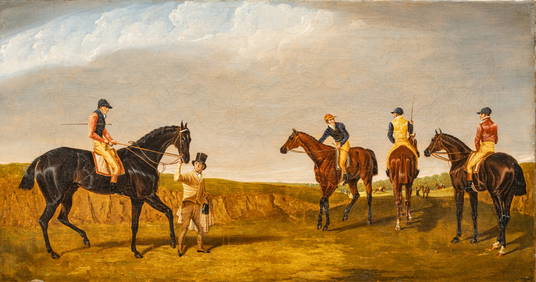
After John Frederick Herring Sr (English, 1795-1869) Oil on Canvas Ca. 1840, "The Doncaster GoldDuMouchelles4.6(829)See Sold PriceMar 15, 2024


![[MAPS]. DUFOUR, Auguste-Henri (1795-1865). Bound Volume of ... (1 of 2)](https://p1.liveauctioneers.com/928/318880/171361279_1_x.jpg?height=282&quality=70&version=1707501302)