JOHN MELISH - MAP OF NEW ORLEANS AND ADJACENT COJohn Melish - Map Of New Orleans And Adjacent Country, 1824 - Giclée On Canvas - 44 X 32 3/8 In. A Giclée Print Is The Highest Quality Print Available Today. Because There Is No Visible Dot Screen PSee Sold Price
JOHN MELISH - MAP OF NEW ORLEANS AND ADJACENT COJohn Melish - Map Of New Orleans And Adjacent Country, 1824 - Giclée On Canvas - 40 X 29 3/8 In. A Giclée Print Is The Highest Quality Print Available Today. Because There Is No Visible Dot Screen PSee Sold Price
JOHN MELISH"MAP OF NEW ORLEANS AND ADJACENT COUNTRThis Is A JOHN MELISH Giclee on CANVAS Titled "MAP OF NEW ORLEANS AND ADJACENT COUNTRY, 1824"Measuring - 30 x 22 in.This Giclée is high-resolution and of the highest quality, has a color permanence rSee Sold Price
John Melish - Map Of New Orleans And Adjacent Country,John Melish - Map Of New Orleans And Adjacent Country, 1815 - 40 X 29 3/8 In. - Giclée On Canvas - Museum Wrapped - Large Piece Of Art - This Piece Is Ready To Hang On Your WallSee Sold Price
JOHN MELISH - MAP OF NEW ORLEANS AND ADJACENT COUNTRY,John Melish - Map Of New Orleans And Adjacent Country, 1815 - 40 X 29 3/8 In. - Giclée On Canvas - Museum Wrapped - Large Piece Of Art - This Piece Is Ready To Hang On Your WallSee Sold Price
JOHN MELISH - MAP OF NEW ORLEANS AND ADJACENT COUNTRY,John Melish - Map Of New Orleans And Adjacent Country, 1815 - 40 X 29 3/8 In. - This Giclée Print Is Gallery Stretched And Ready To Hang Or Lean Against A Wall, Or Display On An Easel. - A Giclée PrSee Sold Price
JOHN MELISH - MAP OF NEW ORLEANS AND ADJACENT COUNTRY,John Melish - Map Of New Orleans And Adjacent Country, 1815 - 44 X 32 1/4 In. - Gallery Stretched The Piece Of Art Is Ready To Hang Or Lean Against A Wall, Or Display On An Easel. - A Giclée Print IsSee Sold Price
SoldJohn Melish (Scottish/American)John Melish (Scottish/American, 1771-1822), "Map of New Orleans and Adjacent Country", Philadelphia, John Melish, 1815, hand-colored engraved map, with folds, as issued, from A Military and TopographiSee Sold Price
SoldMap of New Orleans and Adjacent Country"Map of New Orleans and Adjacent Country" by John Melish (Scottish/American, 1771-1822), hand-colored engraved map from A Military and Topographical Atlas of the United States, published Philadelphia,See Sold Price
Sold[New Orleans Map] 1861[New Orleans Map], "Map of the City of New Orleans, and the Adjacent Towns", 1861, hand-colored lithograph map, from Charles Gardner's New Orleans Directory, lithographed by A. Hoen & Co., Baltimore,See Sold Price
MAPS - Eastern US Cities. MelishEastern United States Cities. John Melish, [Lot of 7] New-York, and Adjacent Country [and] District of Columbia [and] Boston... [and] Baltimore, Annapolis... [and] Charleston... [and] View of the CounSee Sold Price
SoldJohn La TourretteJohn La Tourrette, "Correct Map of the Seat of War and adjacent Country, Compiled from the best Authorities, Extant by John LaTourrette New-Orleans A.D. 1846", printed by Risso Lith., Dumaine St. No.See Sold Price
SoldCORRECT MAP OF THE SEAT OF WAR AND ADJACENT COUNTRY,CORRECT MAP OF THE SEAT OF WAR AND ADJACENT COUNTRY, COMPILED FROM THE BEST AUTHORITIES, EXTANT BY JOHN LATOURRETTE, NEW ORLEANS, RISSO LITHO, 1846, shows locations of the Mexican and American armiesSee Sold Price
Sold(3) Louisiana Law Books 1834, 1839 and 1852Group of three Louisiana Law Books. 1) Code of Practice in Civil Cases for The State of Louisiana by Wheelock & Upton. 1839. E. Johns & Co., New Orleans. Measures 9.5" x 6.25" x 1 5/8". (English & FreSee Sold Price
SoldMap of New Orleans, 1894, by the Matthews-Northrup Co.,Map of New Orleans, 1894, by the Matthews-Northrup Co., hand-colored, presented in a gilt frame, H.- 12 in., W.- 9 in.See Sold Price
SoldRand-McNally Map of New OrleansRand-McNally Map of New Orleans, from the Rand, McNally & Co.'s Business Atlas Map of New Orleans, copyright 1898, sight 21" x 14". Glazed, French matted and presented in a carved giltwood frame.See Sold Price
Sold1886 Crams's Map of New Orleans & Atlanta1886 Crams's Map of New Orleans verso Atlanta G Cram / People's Publishing Co. 1886, New York 11.3 X 9.4 in. Very nice maps showing streets, steam / horse roads, ferries, churches, government buildingSee Sold Price
SoldMap of the Surveyed Part of MichiganJohn Farmer. Engraved pocket map. New York: J.H. Colton & Co., 1837. 23 1/2 x 33 1/2 inche sheet, 33 x 43 inches framed. This is a rare early map of Michigan shortly before it was admitted to the UnioSee Sold Price
SoldNew Orleans 1896Title/Content of Map: New Orleans 1896 Date Printed: 1896 Material/Medium: paper Size: approx. 10.5x 13.5 inches Additional Info: Rand McNally & Co. Universal Atlas of the World Reserve: $25.00 ShippiSee Sold Price
New Orleans 1896Title/Content of Map: New Orleans 1896 Date Printed: 1896 Material/Medium: paper Size: approx. 10.5x 13.5 inches Additional Info: Rand McNally & Co. Universal Atlas of the World Reserve: $25.00 ShippiSee Sold Price
SoldTwo Framed Maps, FranceJohn Tallis & Co., New York map of France drawn & engraved by J. Rapkin, c. 1850, together with a M. Bonne map of Brittany, c. 1790. Larger approx. 16.5 X 20.35" (framed). Shipping Disclaimer: This isSee Sold Price
Wall Map of Upper NYC and Lower Westchester/ also MapsGoldthwaite, William M. (Late 19th-Early 20th Century). Map of Upper New York City and adjacent country. Hyde & Co. for New York Country and Athletic Club. Lithographed map. 1889. 31" x 23" sheet. ShoSee Sold Price
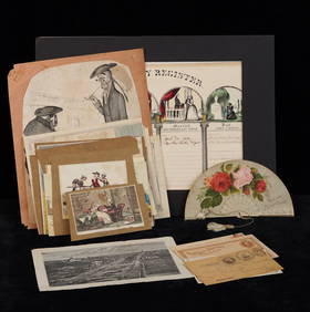
Sold[Louisiana Books][Louisiana Books], three titles including: Lemmon, Alfred; John Magill and Jason Wiese, Charting Louisiana, Five Hundred Years of Maps, New Orleans, The Historic New Orleans Collection, 2003, first edSee Sold Price
SoldCram: Antique Map of New Orleans, 1889Map: 1889 Cram's Map of New Orleans verso Map of San Francisco -- New Orleans verso San Francisco Cartographer: G Cram / People's Publishing Co. Year / Place: 1889, New York Map Dimensions: 11.3 X 9.4See Sold Price
GROUPING OF (19th c) BRITISH SATIRICAL PRINTS etcJohn McInnis Auctioneers,LLC4.6(502)See Sold PriceFeb 24, 2024
Railroad Ephemera Group - Hartford, Providence and Fishkill Railroad, Iron Mountain, SouthernRail & Road Auctions4.6(165)See Sold PriceMar 08, 2024
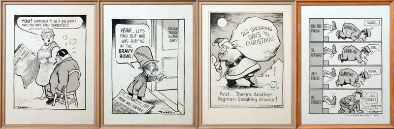
John Churchill Chase (1905-1986, New Orleans), Four Original Ink Editorial Cartoons, c. 1953-1954,Crescent City Auction Gallery4.3(229)See Sold PriceMar 01, 2024
[CLIPPER SHIP CARD]. Sutton & Co’s Dispatch Line for San Fr...Potter & Potter Auctions4.6(539)See Sold PriceMar 07, 2024
Notable Men of New Orleans 1905 - G. Moses & Son, PhotographerJasper524.5(9.8k)See Sold PriceFeb 27, 2024
West Indies Islands. Guadaloupe. | Mariegalante &C. | Antigua.Jasper524.5(9.8k)See Sold PriceFeb 27, 2024
Two Hand-Colored 19th Century Maps of New Orleans and Louisiana, Larger- H.- 12 1/2 in., W.- 15 1/2Crescent City Auction Gallery4.3(229)See Sold PriceMar 08, 2024
Jim Blanchard (American/Louisiana, b. 1955), "Rev. John Bliss Warren House [Maple Street]," H.- 19Crescent City Auction Gallery4.3(229)See Sold PriceMar 09, 2024
Coca Cola 1993 New Orleans Basketball TubeRapid Estate Liquidators and Auction Gallery4.5(1.1k)See Sold PriceFeb 27, 2024
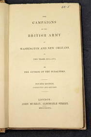
1836 The British Army at Washington & New Orleans HCRapid Estate Liquidators and Auction Gallery4.5(1.1k)See Sold PriceFeb 29, 2024


![[New Orleans Map] 1861 (1 of 2)](https://p1.liveauctioneers.com/268/130466/66335167_1_x.jpg?height=282&quality=70&version=1542127114)


![[Louisiana Books] (1 of 5)](https://p1.liveauctioneers.com/268/56744/27769964_1_x.jpg?height=282&quality=70&version=1402504408)


![[Ambrotype] Identified Tennessee Soldier (1 of 3)](https://p1.liveauctioneers.com/7226/317626/170485496_1_x.jpg?height=282&quality=70&version=1706368022)


![[CLIPPER SHIP CARD]. Sutton & Co’s Dispatch Line for San Fr... (1 of 2)](https://p1.liveauctioneers.com/928/318880/171360962_1_x.jpg?height=282&quality=70&version=1707501302)


![Jim Blanchard (American/Louisiana, b. 1955), "Rev. John Bliss Warren House [Maple Street]," H.- 19 (1 of 9)](https://p1.liveauctioneers.com/328/319807/171922786_1_x.jpg?height=282&quality=70&version=1708137437)