SoldJohn GOSS - Cartes anciennes des grandes villes d'John GOSS - Cartes anciennes des grandes villes d'Europe. Une sélection des plus beaux plans de BRAUN et HOGENBERG. Paris, Solar, 1992. In-folio, reliure d'édition, jaquette. JSee Sold Price
Brandenburg (Le Rouge): Walch, Marquisat et ElectoBrandenburg. Cette Carte du Brandbourg differe des Anciennes de ce qu'elle contient les Grandes Routes des Postes, les Villes Nouvelles de Potsdam, Charlottenbourg, Gransée, &c. Kupferstich mit aSee Sold Price
SoldBrandenburg (Le Rouge): Walch, Marquisat et Electo- Cette Carte du Brandbourg differe des Anciennes de ce qu'elle contient les Grandes Routes des Postes, les Villes Nouvelles de Potsdam, Charlottenbourg, Gransée, &c. Kupferstich mit alt kolorierSee Sold Price
Sold1840 Map Of EgyptColor map of Egypt ("Carte de L'Egypte avec l'indication des Villes Anciennes"), printed in France, 1840. 15 3/4 x 8 7/8 inches. Very good condition (with folds, as published). Unframed.See Sold Price
1840 Map Of EgyptColor map of Egypt ("Carte de L'Egypte avec l'indication des Villes Anciennes"), printed in France, 1840. 15 3/4 x 8 7/8 inches. Very good condition (with folds, as published). Unframed.See Sold Price
SoldKarl BAEDEKER - L'Italie, des Alpes à Naples. Avec 15 gKarl BAEDEKER - L'Italie, des Alpes à Naples. Avec 15 grandes et 49 petites cartes et plans de villes et d'édifices. Leipzig, Karl Baedeker, Paris, Paul Ollendorff, 1901. In-12, pleine percaline rouSee Sold Price
Carte Des Grandes Routes D'angleterre, D'ecosse, EtTitle: Carte Des Grandes Routes D'angleterre, D'ecosse, Et D'irlande Cartographer: VAUGONDY, GILLES ROBERT, sieur de (1686-1766) Publication Date: 1757 Publisher: G. ROBERT DE VAUGONDY Size: Height: 2See Sold Price
SoldDe Vaugondy, Carte des Grandes Routes D'Angleterr[British Isles]. Robert de Vaugondy. Carte Des Grandes Routes D'Angleterre, D'Ecosse, Et De Irlande. 1757. Double-page engraved map, 19 5/8 x 23 3/4 in. Road map of Britain and Ireland, including riveSee Sold Price
Carte Des Grandes Routes D'angleterre, D'ecosse, EtPublication Date: 1757 Title: Carte Des Grandes Routes D'angleterre, D'ecosse, Et D'irlande Cartographer: VAUGONDY, GILLES ROBERT, sieur de (1686-1766) Publisher: G. ROBERT DE VAUGONDY Height: 21.5 WiSee Sold Price
Carte Des Grandes Routes D'angleterre, D'ecosse, EtTitle/Content of Map: Carte Des Grandes Routes D'angleterre, D'ecosse, Et D'irlande Cartographer: VAUGONDY, GILLES ROBERT, sieur de (1686-1766) Height (inches): 21.5 Width (inches): 23Year: 1757 par lSee Sold Price
Carte Des Grandes Routes D'angleterre, D'ecosse, EtReserve Reduced! Title: Carte Des Grandes Routes D'angleterre, D'ecosse, Et D'irlande Publication Date: 1757 Cartographer: VAUGONDY, GILLES ROBERT, sieur de (1686-1766) Material/Medium: G. ROBERT DE VSee Sold Price
Carte Des Grandes Routes D'angleterre, D'ecosse, EtPublication Date: 1757 Title: Carte Des Grandes Routes D'angleterre, D'ecosse, Et D'irlande Cartographer: VAUGONDY, GILLES ROBERT, sieur de (1686-1766) Publisher: G. ROBERT DE VAUGONDY Height: 21.5 WiSee Sold Price
SoldGroup of 5 British Isles mapsRobert de Vaugondy (Gilles & Didier) Carte des Grandes Routes d'Angleterre, d'Ecosse, et d'Irlande,large vignette title of a country inn scene, upper right, engraved map with original hand-colSee Sold Price
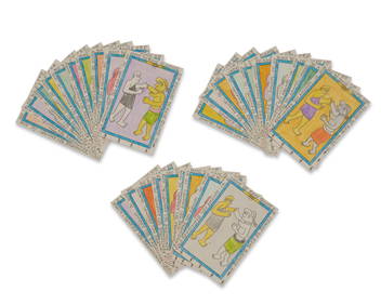
SoldCartes à jouer. Réunion de 27 cartes anciennes.Cartes à jouer. Réunion de 27 cartes anciennes. Le verso des cartes est illustré de sujets en couleur : lapin, chien, coq, renard, sanglier, cheval ou de personnages divers (fermière, maçon, soldSee Sold Price
SoldHawkesworth (John) - Carte et Figures des Voyagesatlas vol", only, of the French edition of Hawkesworth's Voyages to the South Seas, title and 52 single- and double-page, and folding maps and plates, v.s., 230 x 180mm. to 475 x 780mm., some marginalSee Sold Price
Hawkesworth (John) - Carte et Figures des Voyagesatlas vol, only, of the French edition of Hawkesworth's Voyages to the South Seas, title and 52 single- and double-page, and folding maps and plates, v.s., 230 x 180mm. to 475 x 780mm., some marginalSee Sold Price
SoldCook, Cartes et figures des voyages...Cook James, Hawkesworth John, Cartes et figures des voyages […] pour faire des découvertes dans l’Hémisphère Méridional et successivement exécutés par le Commodore ByronSee Sold Price
SoldEnvirons de Liège. Environ 150 cartes postales ancEnvirons de Liège. Environ 150 cartes postales anciennes. Notamment des cartes postales de Chevremont, Seraing, Bressoux, Visé, Awans, Flemalle, et beaucoup d'autres. Ensemble environ 150 cartes poSee Sold Price
Sold(MAP) DE VAUGONDY, GILLES, after. Partie occidentale de(MAP) DE VAUGONDY, GILLES, after Partie occidentale de la carte des anciennes monarchies. Paris, c. 1800. Engraved map with hand-coloring. Framed and matted. 20 x 26 inches.See Sold Price
SoldPAIR FRENCH 18TH C EUROPEAN MONARCHIES MAPSPAIR FRENCH 18TH CENTURY EUROPEAN MONARCHIES MAPS: Circa 1760 French pair of maps depicting ancient monarchies of Europe and Eurasia. Titled ''Partie Occidentale de la Carte des Anciennes Monarchies''See Sold Price
SoldMap, after John Speed, British IslesFramed double-sided engraved and handcolored map, ''Les Isles Brittanicques,'' original from 1665, later copy after Nicholas Sanson (French, 1600-1667), based on maps by John Speed; and ''Carte des IsSee Sold Price
Sold(3) Continental Maps, Hand-Colored EngravingsFour (4) Continental maps, hand-colored engravings, including: (1) "Orbis Romani Pars Occidentalis", 29 3/4" x 21 3/4"; (1) "Partie Occidentale De La Carte des Anciennes Monarchies", 21" x 29 1/4"; (1See Sold Price
SoldINVADER (French, born in 1969)INVADER (Français, né en 1969) 10 Carte d’invasion, des villes suivantes et une planche de Stickers Space de 20 points 10 Invasion Maps, of the following Cities and one Space Stickers page of 20 PSee Sold Price
Map of the Near East in Relation to the Ancient World.Partie Orientale de la Carte des Anciennes Monarchies. Map of the Near East through India. Copperplate engraving. Colored borders. Small inset map in the upper right corner of the modern world: EuropeSee Sold Price
LATE 18TH C. VERY LARGE CHART OF NORTHEAST CANADA BY DES BARRES (1721-1824), 1780, FRAMEDThomaston Place Auction Galleries4.4(386)See Sold PriceFeb 24, 2024
LATE 17TH C. FRENCH MAP OF THE NEW WORLD BY ALEXIS-HUBERT JAILLOT (1632-1712)Thomaston Place Auction Galleries4.4(386)See Sold PriceFeb 24, 2024
UN COUP DE DES JAMAIS N'ABOLIRA LE HASARD 1961John McInnis Auctioneers,LLC4.6(502)See Sold PriceFeb 25, 2024
Migration Period Iron Sword with Garnet and Shell Cross Guard with Gold and Amber Sword BeadTimeLine Auctions Ltd.4.5(183)See Sold PriceMar 05, 2024
Maria Helena Vieira da Silva (Portuguese, 1903-1992) - Sans Titre (Rooftops)Freeman's | Hindman4.5(158)See Sold PriceFeb 27, 2024
Frederic Bruly Bouabre (1923-2014), "La Rencontre des Amants Hommes des Races de Couleurs," 2010,John Moran Auctioneers, Inc.4.7(453)See Sold PriceFeb 27, 2024
Frederic Bruly Bouabre (1923-2014), "Guie Guie: Les Yeux des Hommes Zerepkapka observe devant saJohn Moran Auctioneers, Inc.4.7(453)See Sold PriceFeb 27, 2024
[MAPS]. DUFOUR, Auguste-Henri (1795-1865). Bound Volume of ...Potter & Potter Auctions4.6(539)See Sold PriceMar 07, 2024
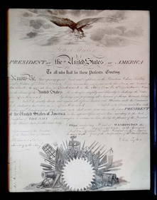
TYLER, John, 10e président des États-Unis d’Amérique / 10th President of theIEGOR Auctions4.2(133)See Sold PriceFeb 28, 2024
Map of St. Kitts and Nevis Depot de la Marine, Paris, 1758Global Auctions Company4.3(36)See Sold PriceMar 03, 2024
Duval - Pair: Map of Georgia & Map of Moscow, RussiaTrillium Antique Prints & Rare Books4.5(30)See Sold PriceFeb 24, 2024
Duval - Pair: Map of India & Map of MaldivesTrillium Antique Prints & Rare Books4.5(30)See Sold PriceFeb 24, 2024
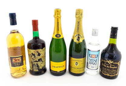
Six bottles of wines and spirits to include a 750ml Côtes du Tarn Moelleux 2001, Almeida 1966Claydon Auctioneers Ltd4.3(125)See Sold PriceFeb 26, 2024
1758 MAP PARTIE DE LA MER GLACIALE contenants La Nouvelle Zemble RUSSIA antiqueJasper524.5(9.8k)See Sold PriceFeb 27, 2024
Railways & Transport.- [Prospectus] The Dorking, Brighton, and Arundel Atmospheric Railway, byForum Auctions4.3(52)See Sold PriceFeb 29, 2024
1764 Bellin Chart of Three South Haitian Bays -- Carte des Bayes du Mesle des Flamands et deJasper524.5(9.8k)See Sold PriceFeb 27, 2024
Rivières de Sanaga & Gambra'. Senegal Gambia rivers. Guinea. BELLIN 1746 mapJasper524.5(9.8k)See Sold PriceFeb 28, 2024


![[MAPS]. DUFOUR, Auguste-Henri (1795-1865). Bound Volume of ... (1 of 2)](https://p1.liveauctioneers.com/928/318880/171361279_1_x.jpg?height=282&quality=70&version=1707501302)


![Railways & Transport.- [Prospectus] The Dorking, Brighton, and Arundel Atmospheric Railway, by (1 of 1)](https://p1.liveauctioneers.com/5458/319736/171654703_1_x.jpg?height=282&quality=70&version=1708010439)


