SoldJ. Blair Map of North AmericaA Map of North America, Published by John Blair, LLD & FRS, c. 1779. Engraved map, "From the Latest Surveys and Maps by John Blair LLD & FRS as a Supplement to His Tables of Chronology", engraved by TSee Sold Price
SoldBlair - Map of North America, 1768[A Map of North America from the Latest Surveys and Maps by John Blair, L.L.D. & F.R.S. as a Supplement to His Tables of Chronology], from Thomas Kitchins, [A General Atlas], (London, 1768), hand coloSee Sold Price
SoldSMITH, J. CALVIN. Map of North America.SMITH, J. CALVIN. Map of North America. Engraved folding map with a vignette of the Gold Region of California, 565x485 mm, margins ample on 3 sides, left margin chipped in lower quadrant affecting neaSee Sold Price
J Arrowsmith: Map of North America, 1860Map: North America Maker: J. Arrowsmith Publisher: A. Hoen & Co Published: 1860 in Baltimore Size: Quarto, 13 x 17 inches Rare American Reprinting of An Official English Map "Drawn by J. Arrowsmith. .See Sold Price
SoldMap, North America, J. Rapkin, C. 1850This map has scattered vignettes including portraits of Benjamin Franklin and George Washington, the Washington Monument, and a Buffalo Hunt. The map itself has hand tinted borders.See Sold Price
SoldBLAIR, JOHN. A Map of North America from the LBLAIR, JOHN. A Map of North America from the Latest Surveys and Maps. Double-page engraved map engraved by Thomas Kitchin, 425x590 mm, wide margins; nicely hand-colored. McCorkle 728.2. London, 1768See Sold Price
SoldBLAIR, JOHN. A Map of North America.BLAIR, JOHN. A Map of North America. Engraved folding map, 430x600 mm, wide margins; nicely hand-colored. London, 1768 Very lovely map and rarely seen. All items are offered for sale subject toSee Sold Price
SoldJ. Gibson, 1763 Map of North America.With inset of Bermuda. Includes Pegasus Bermuda certificate. Image: 8" x 9".See Sold Price
SoldEarly Civil War era map of AmericaNice example of A. J. Johnson's 1862 map of North America. Presents a fascinating snapshot of North America just after the outbreak of the American Civil War. States generally follow the 1861 configurSee Sold Price
Sold4 Antique MapsIncludes McNally's System of Geography map of NJ, PA, DE, & MD drawn by J. Wells, 1860 map of North America by S. Augustus Mitchell, Jr, Denver News Co. US. Map, and 1924 map of Los Angeles. Los AngelSee Sold Price
SoldJ.B. Homanno color engraved map of North AmericaJ.B. Homanno color engraved map of North America, titled Amplissimae Regionis Mississipi, 19'' x 22 3/4''.See Sold Price
A Monumental Wall Map of Early 19th-century America,VANCE, David H. (19th Century), engraved by J.H. Young (1792- 1864). Map of North America including recent geographical discoveries. Engraved map in 6 parts with original hand color in outline. PhiladSee Sold Price
Migeon (J.) Amérique Septentrionale[Migeon (J.)] Amérique Septentrionale, engraved map of North America with original hand-colouring, vignette view of the Niagara Falls (uncoloured), 280 x 375mm., [Paris], [1884], and 5 other sSee Sold Price
SoldMap, New Map of North America, J. Cary, 1806This lot is a map created by famed cartographer John Cary. It depicts the United States and the rest of North America following the Louisiana Purchase and the changing of borders. The hand-colorings aSee Sold Price
SoldJ. Gibson North America MapJohn Gibson, British, 1750-1792. Engraved map of North America with "Degrees of Longitude West from London" and "Hours of Time West from London". Not examined out of the frame. Minor creasing evident.See Sold Price
SoldHuge/clean 1867 wall map of North America, J. T. LloydHuge antique wall map in rare condition...varnish appears nearly fresh with absolutely no cracking. Includes original rollers which are also in great condition. Great hand-coloring and strong print. TSee Sold Price
Huge/clean 1867 wall map of North America, J. T. LloydReserve Reduced! Huge antique wall map in rare condition...varnish appears nearly fresh with absolutely no cracking. Includes original rollers which are also in great condition. Great hand-coloring anSee Sold Price
(2) MAPS, NORTH & SOUTH AMERICA, J. WYLD, HEWITT(lot of 2) Framed maps of America, comprising: (1) North and South America, drawn by James Wyld (English, 1812-1887), engraved by Hewitt, Sc. 1 Buckingham Place, Fitzroy Square, plate 36, bottom leftSee Sold Price
SoldJohn Blair (1722-1782, British), "A Map of NorthJohn Blair (1722-1782, British), "A Map of North America, hand colored, H. - 18 in., W. - 22 3/4 in.See Sold Price
SoldSharpe's Corresponding Map [British North America]J. Sharpe, Chapman & Hall map of British North America, circa 1840's (exact date of map unverified). Measures 12.25-in. x 16-in. image size, 13.875-in. x 18.375-in. sheet size. Unframed, loose and notSee Sold Price
SoldNorth America According to the Latest ObservationsHeading: (Map - North America) Author: [Senex, J.] Title: North America According to the Latest Observations Place Published: Publisher: Date Published: c.1730 Description:See Sold Price
SoldRare 1850 map of North America by J. Calvin SmithMap of North America. J. Calvin Smith (fl. 1829-1855). Lithographed map with original hand color. New York: J. Disturnell, 1850. 24 x 19 1/2 inches sheet. Rare 1850 map of North America by J. Calvin SSee Sold Price
SoldPownall Map of Middle British ColoniesEvans, Lewis (1700-1756) & Pownall, Thomas (1722-1805) A Map of Middle British Colonies in North America... Engraved map. London: J. Almon, 1776. 19 3/4" x 32 1/2" sheet, 29" x 42" framed. ownall's maSee Sold Price
SoldD'Anville (J.B.B.) Hémisphere OccidentalD'Anville (J.B.B.) Hémisphere Occidentalcircular map of North and South America, engraved map with full hand-colouring, on two sheets joined, 675 x 620mm., horizontal folds and soft creasing,See Sold Price
5 Dollars - Elizabeth II Map of North AmericaWeatherham Estate Treasures3.9(157)See Sold PriceMar 07, 2024
Arrowsmith & Lewis - Map of North AmericaTrillium Antique Prints & Rare Books4.5(30)See Sold PriceFeb 24, 2024
Map: An 18thC engraved and hand coloured map of North America and South America, titled DeClaydon Auctioneers Ltd4.3(125)See Sold PriceFeb 26, 2024
1822 MAP of NORTH & SOUTH AMERICA GEOGRAPHICAL STATISTICAL HISTORICAL antiqueJasper524.5(9.8k)See Sold PriceFeb 27, 2024
New and Correct Map of North America With the West India Islands,Jasper524.5(9.8k)See Sold PriceFeb 27, 2024
Mexico, Central America and West Indies Physical PoliticalJasper524.5(9.8k)See Sold PriceFeb 27, 2024
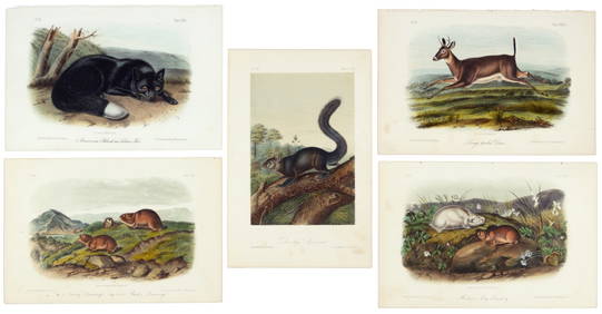
First 50 plates from Audubon's Quad Quarto (all in Vol. I)PBA Galleries4.7(381)See Sold PriceMar 07, 2024
Nearly complete set of plates from Vol. III Quad QuartoPBA Galleries4.7(381)See Sold PriceMar 07, 2024
Italian edition of Sanson's map of North America, 1677PBA Galleries4.7(381)See Sold PriceMar 07, 2024
Blackie (Pub) 1882 Folio Map. United States of North AmericaAlbion Auctions4.6(336)See Sold PriceMar 01, 2024


![Sharpe's Corresponding Map [British North America] (1 of 3)](https://p1.liveauctioneers.com/5755/162895/82236278_1_x.jpg?height=282&quality=70&version=1582932540)