SoldJ. B. Homann, Map of Colonial New England, 1720.Johann Baptist Homann, "Nova Anglia Septentrionali Americae implantata Anglorumque coloniis florentissima" Map of Colonial New England, 1720 .(SVAG2205) {WK} Measurements: 22.5 x 19 inches Condition:See Sold Price
SoldMap of North AmericaNova Anglia by J.B. Homann 19" x 22 1/2" circa 1720 together with another map of North America by S.D.U.K., sheet VI, 1832, showing New England, 14" x 12 1/2" SHIPPING: Buyer is responsible for arrangSee Sold Price
SoldJ.B. HOMANN ANTIQUE MAP OF MEXICO & NEW SPAINJ. B. Homann's map of Mexico, Florida, New England, the West Indies, and the Mississippi Valley. Dimensions: (Frame) H 20.5" x W 24.5", (Sight) H 18.5" x W 22..25" Condition: Colors faded. Some wear tSee Sold Price
Homann: Map of New England & Nova Anglia, 1716Nova Anglia, J. B. Homann, 1716. Double Folio approximately 19"" x 23" - Copperplate engraving original hand color. This map of New England covers the region from New Jersey to north of Maine. It wasSee Sold Price
Carinthia Duchy, Austria 1720 Engraved Map J.B. HomannJohann Baptist Homann (1663-1724): New and precise Candia Duchy Map of the Upper and Lower divisions and added parts of the archbishopric of Salzburg proper and even several Dynasties, at the EmperorSee Sold Price
SoldHomann map of New England, 1720Heading: Author: Homann, Johann Baptiste Title: Nova Anglia Septentrionali Americae implantata Anglorumque coloniis florentissima Place Published: Nuremberg Publisher: Date Published: 1720See Sold Price
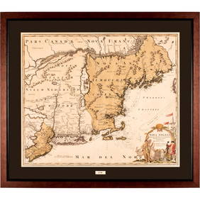
Homann: Antique Map of New England, 1720The map names New England as "Almouchi Cosen" as well as Nova Anglia, while present-day New York State is named variously as New Jork, Nieuw Nederland and Novum Belgium (New York, New Netherlands andSee Sold Price
Homann: Antique Map of New England, 1720Nova Anglia'.New England Novum Belgium.Long Island Jorck Shire. The map names New England as "Almouchi Cosen" as well as Nova Anglia, while present-day New York State is named variously as New Jork, NSee Sold Price
SoldHomann: Antique Map of New England, 1720The map names New England as "Almouchi Cosen" as well as Nova Anglia, while present-day New York State is named variously as New Jork, Nieuw Nederland and Novum Belgium (New York, New Netherlands andSee Sold Price
Sold"Neue Tafel vor alle Liebhabers und See-fahrende"J.B. Homann. Year 1720. "New board for all friends of the sea...". Beautiful and rare copper engraving by J.B. Homann (German) Plate size: 49.5 cm x 57.5 Printed on laid paper with watermarkSee Sold Price
SoldMAP - Colonial New England. HomannColonial New England & Mid-Atlantic United States. Johann Baptist Homann, Nova Anglia Septentrionali Americae Implantata Anglorumque Coloniis Florentissima, 1730 (circa). Hand Color. This handsome mapSee Sold Price
C. 1720 MAP OF IRELANDHiberniae Regnum .... Maker: J. B. Homann, ca.1720Copper engraving and hand color on paper Dimensions: Frame H 29.5" x W 26"; Sight H 23" x W 19.5"Condition: GoodNote: "Antique map of Ireland. The elaSee Sold Price
SoldJ.B Homann c.1737 Map of Hiberniae RegnumJ.B Homann c.1737 unframed coloured engraving, Map of Hiberniae Regnum, 22 x 18.5 ins.See Sold Price
SoldJ.B Homann c.1737 Map of Hiberniae Regnum, 22 x 1J.B Homann c.1737 unframed coloured engraving, Map of Hiberniae Regnum, 22 x 18.5 ins.See Sold Price
SoldJ.B Homann c.1737 Map of Hiberniae Regnum, 22 x 1J.B Homann c.1737 unframed coloured engraving, Map of Hiberniae Regnum, 22 x 18.5 ins.See Sold Price
Untitled. [New England, Acadia, Quebec, St. LawrenceTitle/Content of Map: Untitled. [New England, Acadia, Quebec, St. Lawrence River, Etc.] Cartographer: ANVILLE, J. B. B. D' Height (inches): 18.75 Width (inches): 22.5Year: 1748 Eastern Canada & New EnSee Sold Price
SoldJ.B. Homann, 18th c. map of IrelandJ.B. Homann, 18th c. map of Ireland, Johann Baptist Homann (German,1664-1724), "Hiberniae Regnum tam in Praecipuas Ultoniae, Connaciae, Laceniae et Momoniae quam in Minores", c. 1720, 24"h x 20.5"w (sSee Sold Price
Homann Heirs: Antique Map of the World, 1720Map: World Date Printed: 1720 Cartographer: Homann Heirs Material/Medium: Paper Size: 21" x 24" Double page on thick paper. One of the most decorative world maps of the 1700's. J.B. Homann is one of tSee Sold Price
Sold1 piece. Hand-Colored Engraved Map. Homann, J.B.1 piece. Hand-Colored Engraved Map. Homann, J.B. Aegyptus Hodierna." Nuremberg, [ca. 1720]. 23 x 19 1/2 inches (584 x 495 mm), good margins. Small repairs to verso, scattered minor smudging. Old (origSee Sold Price
Soldc 1730 Hand-Colored Map of New England titled, NOVA ANGLIA Septentrionali America by Johannes HomannHistoric Maps Beautiful Circa 1730 "Homann" Map of Early New England c. 1730 Colonial Period, Hand-Colored Copper-plate Engraved Map of New England in America entitled, "NOVA ANGLIA Septentrionali AmeSee Sold Price
Soldc. 1730 Map of New England NOVA ANGLIA by HomannColonial America Beautiful circa 1730 “Homann” Map of Early New England c. 1730 Colonial Period, Hand-Colored Copper-plate Engraved Map of New England in America entitled, “NOVA ANGLIA SeptentriSee Sold Price
SoldTopographic MapTopographic Map, J B Homann, Regni Norvegiae, engraving ca.1720, 59x49 cmSee Sold Price
Homann: Antique Map of Malta & Valetta View, 1720Map: Insularum Maltae et Gozae Cartographer: J. B. Homann Place & Date: Nurnberg / 1720 Size: 20" x 18" Condition: old color on islands and inset plan, cartouche and inset view in b&w; light overall aSee Sold Price
Homann: Antique Map of the World in Hemispheres, 1720Map: Planiglobii Terrestris Cumutroo Hemisphaerio Celesti Date Printed: 1720 Cartographer: J. B. Homann Material/Medium: Paper Size: 21" x 24" Condition: Excellent One of the most decorative world mapSee Sold Price
George J. Rogers "Citadel" Oil on Canvas, 1962Auctions at Showplace4.5(726)See Sold PriceMar 12, 2024
1902 MANCHESTERS BASEBALL TEAM COMPOSITEJohn McInnis Auctioneers,LLC4.6(502)See Sold PriceFeb 25, 2024
1952 J.F.K. CHRISTMAS GIFT to HELEN KEYESJohn McInnis Auctioneers,LLC4.6(502)See Sold PriceFeb 25, 2024
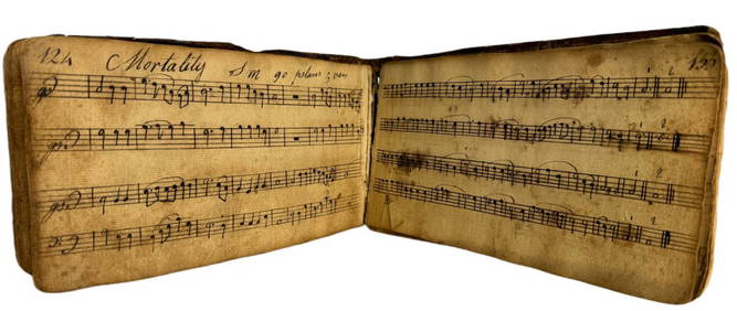
1798 Hand-Written Colonial American Hymnal Leather-Bound Book Signed Abraham Ford New England TownsHess Fine Auctions4.5(197)See Sold PriceMar 02, 2024
Egyptian Limestone Relief with Bound Asiatic CaptiveTimeLine Auctions Ltd.4.5(183)See Sold PriceMar 06, 2024
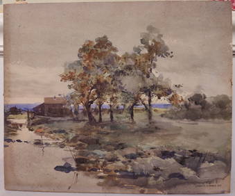
J Francis Murphy W/C New England Landscape PaintingHeritage Gallery Auctions4.4(56)See Sold PriceMar 10, 2024
1849 THE NEW-ENGLAND MERCANTILE UNIONNorth American Artifact Auctions4.6(182)See Sold PriceApr 20, 2024
The Ballerina Bronze Sculpture Edgar Degas casting stamps J B Deposée A7720Bazaar of Persia4.3(23)See Sold PriceFeb 24, 2024
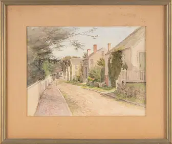
JANE BREWSTER REID (New York/Illinois, 1862-1966), "Nantucket Street"., Watercolor on paper, 8.5" xEldred's4.7(409)See Sold PriceMar 07, 2024
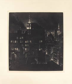
William J Behnken "Manhattan Chiaroscuro" AquatintAuctions at Showplace4.5(726)See Sold PriceApr 07, 2024
BRADFORD FREEMAN OIL ON CANVAS, AFTER THE STORM.William Smith Auctions4.6(146)See Sold PriceMar 06, 2024
Herman Moll A New Map of Ye North Parts of AmericaWillow Auction House4.5(283)See Sold PriceMar 14, 2024