MATTHEWS c1856 Map Of Upper Canada Ontario Indian Land Agency Divisions Scarce!Luis Porretta Fine Arts4.3(10)See Sold PriceMar 02, 2024
DEVINE c1856 Dr Salters Map Of Lake Huron Ontario Indian Lands etc. No. 7 ScarceLuis Porretta Fine Arts4.3(10)See Sold PriceMar 02, 2024
DUNLEVIE c1856 Map Counties Of Gaspe & Bonaventure Quebec Canada SCARCE! #1Luis Porretta Fine Arts4.3(10)See Sold PriceMar 02, 2024
DUNLEVIE c1856 Map Counties Of Gaspe & Bonaventure Quebec Canada SCARCE! #2Luis Porretta Fine Arts4.3(10)See Sold PriceMar 02, 2024
Map UNITED COUNTIES LEEDS & GRENVILLE by Walling 1861 Rare Canada Map 5ft x 5ftLuis Porretta Fine Arts4.3(10)See Sold PriceMar 02, 2024
Ambroise TARDIEU c1822 Map Venice Napoleon Italian Campaign 17" x 11"Luis Porretta Fine Arts4.3(10)See Sold PriceMar 02, 2024
J Arrowsmith: Map of North America, 1860Map: North America Maker: J. Arrowsmith Publisher: A. Hoen & Co Published: 1860 in Baltimore Size: Quarto, 13 x 17 inches Rare American Reprinting of An Official English Map "Drawn by J. Arrowsmith. .See Sold Price
SoldJ. Arrowsmith British North America MapMap: British North America Map Maker: J. Arrowsmith It is printed on high-quality paper Size: approximately 24 inches high x 18inches wide. Reproduction of an antique map entitled “British NorthSee Sold Price
SoldArrowsmith map, America, 1844.[Americas]. J. Arrowsmith. America. Double-page engraved map of North and South America. Lon: Arrowsmith, 1844. 25 x 20 3/8 in. Number ''39'' upper right of map, from The London Atlas Of Universal GeoSee Sold Price
Sold4 Antique MapsIncludes McNally's System of Geography map of NJ, PA, DE, & MD drawn by J. Wells, 1860 map of North America by S. Augustus Mitchell, Jr, Denver News Co. US. Map, and 1924 map of Los Angeles. Los AngelSee Sold Price
SoldTwo Maps: consisting of J. H. Colton, "North America,"Two Maps: consisting of J. H. Colton, "North America," 1860, hand colored, H.- 13 3/4 in., W.- 11 1/4 in.; together with Johnson & Browning, "Africa," 1855, hand colored, H.- 17 1/2 in., W.- 16 in. (2See Sold Price
SoldEttling: Map of United States of North America, 1860United States of North America (Eastern & Central) T. J. Ettling, c1860 17 x 25. This great Civil War era map covers the country from the Rocky Mountains to the Atlantic seaboard. The map is engravedSee Sold Price
Nine maps, most from J.H. Colton and successorsTitle: Nine maps, most from J.H. Colton and successors, of the United States, is various parts, and the world Author: Colton, J.H., et al. Description: Includes: Johnson's North America. c.1860. * ColSee Sold Price
SoldUNITED STATES 1860 MAP, J.W. LOWRY, TERRITORIESFramed map: "The United States of North America (General Map)" c. 1860, drawn and engraved by J.W. Lowry (Joseph Wilson Lowry, British, 1803-1879), published by Blackie & Son, Glasgow, Edinburgh & LonSee Sold Price
SoldUNITED STATES 1860 MAP, J.W. LOWRY, TERRITORIESFramed map of "The United States of North America (General Map)", c. 1860, "drawn and engraved by" J.W. Lowry (Joseph Wilson Lowry, British, 1803-1879), published by Blackie & Son, Glasgow, EdinburghSee Sold Price
1860 Map of CanadaTitle: 1860 Map of Canada Author: Lowry Medium: Dimensions: 21.5"X15" Description: Map of British North America-present day Canada dated 1860. Drawn and engraved by J.W. Lowry in London. Published bySee Sold Price
Arrowsmith map of Americas independent TexasTitle: America Author: Arrowsmith, J[ohn] Description: Copper-engraved map, hand-colored in outline. 59.5x47.5 cm (23½x18¾").Shows both North and South America. Texas represented as a separate natioSee Sold Price
North America. Sheet IV,Title: North America. Sheet IV, Publication Date: 1860 ca. Cartographer: Walker, J. & C. Publisher: Edward Stanford/S.D.U.K.Size: 11.8Height - 15.5Width Lake Superior reduced from the Admiralty SurveySee Sold Price
SoldMitchell: Antique Map of North America, 1860Map of North America Showing Its Political Divisions and Recent Discoveries in the Polar Regions. This is the 1860 pre-Civil War plate, but was published in 1866 by Mitchell in his New General Atlas.See Sold Price
Ettling: Antique Civil War Map of North America, 1860U. S. & North America with oddly shaped Dakota--Ettling c1860. This uncommon Civil War era engraved map shows a very unusual configuration for Dakota. In this map the borders of Wyoming Territory haveSee Sold Price
SoldBlakie: Antique Map of North America, 1860Map: 1860 Blakie Map of North America -- North America Cartographer: W Blackie and Son Year / Place: 1860, London, Glasgow Dimensions: 14.5 x 12.2 in. Condition: Very Good. Nice impression and excelleSee Sold Price
SoldFullarton: Antique Map of North America, 1860Map: 1860 Fullarton Map of North America -- North America Cartographer: A Fullarton & Co. Year / Place: 1860 c., Edinburgh Map Dimensions: 18.5 x 16 in. Condition: Very good. Nice pastel colors. ModesSee Sold Price
Colton: Map of North America, 1860Map: North America Date: 1860 Size: 11.5 x 13.5 inches From Colton's "School Atlas". Alaska as "Russian Possessions" and Canada as "British Possessions". Please note that this lot has a confidential rSee Sold Price
Fullarton: Map of North America, 1860Map: 1860 Fullarton Map of North America -- North America Cartographer: A Fullarton & Co. Year / Place: 1860 c., Edinburgh Map Dimensions: 18.5 x 16 in. Condition: Very good. Nice pastel colors. ModesSee Sold Price
Johnston: Map of North America, 1860Map: North America Maker: W. & A.K. Johnston, Keith Johnston Published: 1860 in Edinburgh Size: Folio, 24.2 x 19.25 inches Plate 41 from Keith Johnston's General atlas Boundaries for New Mexico and ArSee Sold Price
Antique Map of North America, 1860Map: Northern America 1860 Copper Engraving Date: 1860 circa LEAF DIMENSION: 9.64x7.28 inches ENGRAVING DIMENSION: 8.66x6.5 inches AMERICA SETTENTRIONALE. Very beautiful copper engraving of around 186See Sold Price
Mid 19th C Hand Drawn Map of North AmericaMid 19th C Hand Drawn Map of North America 1860 9" by 13" framed Pen and ink. Probably early achool exercise Shipping: Domestic: Flat-rate of $15.00 to anywhere within the contiguous U.S. InternationaSee Sold Price
SoldJ. Blair Map of North AmericaA Map of North America, Published by John Blair, LLD & FRS, c. 1779. Engraved map, "From the Latest Surveys and Maps by John Blair LLD & FRS as a Supplement to His Tables of Chronology", engraved by TSee Sold Price
SoldSMITH, J. CALVIN. Map of North America.SMITH, J. CALVIN. Map of North America. Engraved folding map with a vignette of the Gold Region of California, 565x485 mm, margins ample on 3 sides, left margin chipped in lower quadrant affecting neaSee Sold Price
SoldArrowsmith & Lewis Map Of North AmericaArrowsmith & Lewis Map Of North America: This has now been removed from the frame, revealing condition issues in the margins, as seen in detail photos. The map was professionally mounted onto heaSee Sold Price
5 Dollars - Elizabeth II Map of North AmericaWeatherham Estate Treasures3.9(157)See Sold PriceMar 07, 2024
Arrowsmith & Lewis - Map of PolynesiaTrillium Antique Prints & Rare Books4.5(30)See Sold PriceFeb 24, 2024
Arrowsmith & Lewis - Map of North AmericaTrillium Antique Prints & Rare Books4.5(30)See Sold PriceFeb 24, 2024
Arrowsmith & Lewis - Map of the World on Mercator's ProjectionTrillium Antique Prints & Rare Books4.5(30)See Sold PriceFeb 24, 2024
Arrowsmith & Lewis - Map of LouisianaTrillium Antique Prints & Rare Books4.5(30)See Sold PriceFeb 24, 2024
Arrowsmith & Lewis - Map of the United StatesTrillium Antique Prints & Rare Books4.5(30)See Sold PriceFeb 24, 2024
Map: An 18thC engraved and hand coloured map of North America and South America, titled DeClaydon Auctioneers Ltd4.3(125)See Sold PriceFeb 26, 2024
New and Correct Map of North America With the West India Islands,Jasper524.5(9.8k)See Sold PriceFeb 27, 2024
Mexico, Central America and West Indies Physical PoliticalJasper524.5(9.8k)See Sold PriceFeb 27, 2024
First 50 plates from Audubon's Quad Quarto (all in Vol. I)PBA Galleries4.7(381)See Sold PriceMar 07, 2024
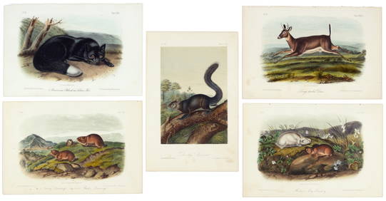
Nearly complete set of plates from Vol. III Quad QuartoPBA Galleries4.7(381)See Sold PriceMar 07, 2024
Italian edition of Sanson's map of North America, 1677PBA Galleries4.7(381)See Sold PriceMar 07, 2024