SoldItaly 1747 Antique Map. View of Genoa, Ships"A View of the City of Genoa" Copper Plate Published 1732-85, London for "The London Magazine" Folds as issued. Paper Size: 11.5 x 8 inch (29 x 20cm) Good ConditionSee Sold Price
Mallet: Antique Map, View of St Augustine Florida, 1683St Augus(tine) de Floride' Decorative view of the town of St Augustine. Ship. Port. St. Augustine (Spanish: San Agustin) is a city in Northeast Florida and the oldest continuously occupied European-esSee Sold Price
SoldMallet: Antique Map, City View of Amsterdam, 1683Title: 'Amsterdam' Decorative view of the city. Many ships. Netherlands. Date Printed: 1683 Image Size: Approx Overall page size 13 x 21cm approximately (5 x 8 inches); image size 10.5 x 14.5cm approxSee Sold Price
SoldBarlow 1807 Antique Map of ItalyCopper Engraved Map Published 1807 by Brightly & Kinnersley, Bungay, England for "A General View of the World, Geographical, Historical and Philosophical" by The Rev. E. Blomfield. Maps Engraved by BaSee Sold Price
Italie. Antique map of Italy. BONNE 1789 old vintageTITLE/CONTENT OF MAP: 'Italie [Italy]' The top image on the right hand side shows the entire map. To view a close up of the map showing the level of printed detail, please click on the bottom image onSee Sold Price
Sold(Maps and Charts, Italy), Braun, Georg, and Hogenb(Maps and Charts, Italy), Braun, Georg, and Hogenberg, Franz, Genua [with] Florentia, [Cologne, 1572 or later], from Civitates orbis terrarum, hand-colored city view of Genoa and Florence, double-foliSee Sold Price
View of Mt Vesuvius Gouache on Artist PaperAntique view of Mt. Vesuvius, Italy with sailing ship flying the French flag, gouache on artist paper, unsigned, 13" x 21", framed 20" x 29".See Sold Price
Map of Italy, 1868Original engraving from Johnson's Atlas of the World, 1868. Map includes vignette of Malta and details cities, towns and territories. Dimensions: 18" x 26". This item ships from Ocean View, DE.See Sold Price
Mount & Page: Antique Sea Chart Map of Savona, 1747Title/Content of Map: 'The city and haven of Savona' Italy sea chart Date Printed: 1747 Image Size: Approx 13.0 x 18.5cm, 5.25 x 7.25 inches (Medium) Type: Antique 18th century copperplate map ConditiSee Sold Price
Sold1849 Map of East Canada & New BrunswickOriginal 1849 Antique engraved map by J Rapkin, published by John Tallis. Original outline hand color, decorative border & inset vignette views of North American Indians, bison & ships in the whalingSee Sold Price
1849 Map of East Canada & New BrunswickOriginal 1849 Antique engraved map by J Rapkin, published by John Tallis. Original outline hand color, decorative border & inset vignette views of North American Indians, bison & ships in the whalingSee Sold Price
Sold1849 Map of East Canada & New BrunswickOriginal 1849 Antique engraved map by J Rapkin, published by John Tallis. Original outline hand color, decorative border & inset vignette views of North American Indians, bison & ships in theSee Sold Price
Sold1849 Map of East Canada & New BrunswickOriginal 1849 Antique engraved map by J Rapkin, published by John Tallis. Original outline hand color, decorative border & inset vignette views of North American Indians, bison & ships in the whalingSee Sold Price
Sold1849 Map of East Canada & New BrunswickOriginal 1849 Antique engraved map by J Rapkin, published by John Tallis. Original outline hand color, decorative border & inset vignette views of North American Indians, bison & ships in theSee Sold Price
1849 Map of East Canada & New BrunswickOriginal 1849 Antique engraved map by J Rapkin, published by John Tallis. Original outline hand color, decorative border & inset vignette views of North American Indians, bison & ships in the whalingSee Sold Price
1849 Map of East Canada & New BrunswickOriginal 1849 Antique engraved map by J Rapkin, published by John Tallis. Original outline hand color, decorative border & inset vignette views of North American Indians, bison & ships in the whalingSee Sold Price
1849 Map of East Canada & New BrunswickOriginal 1849 Antique engraved map by J Rapkin, published by John Tallis. Original outline hand color, decorative border & inset vignette views of North American Indians, bison & ships in the whalingSee Sold Price
Original 1849 Map of East Canada & New BrunswickOriginal 1849 Antique engraved map by J Rapkin, published by John Tallis. Original outline hand color, decorative border & inset vignette views of North American Indians, Bison & ships in the WhalingSee Sold Price
1849 Map of East Canada & New BrunswickOriginal 1849 Antique engraved map by J Rapkin, published by John Tallis. Original outline hand color, decorative border & inset vignette views of North American Indians, bison & ships in the whalingSee Sold Price
1849 Map of East Canada & New BrunswickOriginal 1849 Antique engraved map by J Rapkin, published by John Tallis. Original outline hand color, decorative border & inset vignette views of North American Indians, bison & ships in the whalingSee Sold Price
1849 Map of East Canada & New BrunswickOriginal 1849 Antique engraved map by J Rapkin, published by John Tallis. Original outline hand color, decorative border & inset vignette views of North American Indians, bison & ships in the whalingSee Sold Price
Mount & Page: Antique Sea Chart Map of Messina, 1747Title/Content of Map: 'The haven of Messina' Sicily, Italy. sea chart town plan Date Printed: 1747 Image Size: Approx 11.5 x 23.5cm, 4.5 x 9.25 inches (Medium) Type: Antique 18th century copperplate mSee Sold Price
SoldHarbor Defence maps of Genoa and Venice ItalyAntique map showing Harbor Defences of the cities of Venice and Genoa Italy . Nice condition and marked on bottom Defence of Naval Depot and City of Venice and the other side Defences of Naval Depot aSee Sold Price
SoldThomson: Antique Chart Map of Mediterranean Sea, 1817Chart of the Mediterranean Sea. Bay & roads of Marseilles. The harbour of Genoa. Plan of the Rock and Bay of Gibraltar, shewing the position of the combined fleet and attack of the battering ships inSee Sold Price
A quantity of World War II / Two military ephemera to include assorted 1940s newspapers pages toClaydon Auctioneers Ltd4.3(125)See Sold PriceFeb 26, 2024
Guinea-Bissau. Cacheu town & Fortaleza de São José da Amura. SCHLEY 1747 printJasper524.5(9.7k)See Sold PriceFeb 28, 2024
Cooke, George 1801 Antique Map. Italy, Sicily, Sardinia & CorsicaAlbion Auctions4.7(335)See Sold PriceMar 01, 2024
Carl Johan Billmark - Set of 4 Prints depicting Rome, Italy - Church in Sweden - Views of EuropeProverde Auctions4.3(3)See Sold PriceFeb 28, 2024
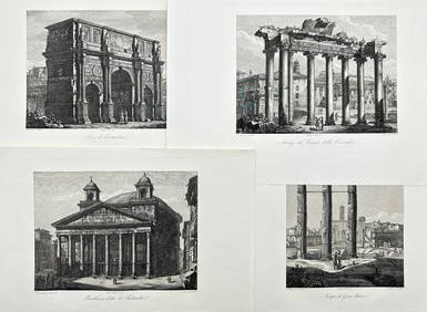
Domenico Amici - Set of 4 prints - Tempio di Giove Statore - Arco di Costantino in Rome, ItalyProverde Auctions4.3(3)See Sold PriceFeb 28, 2024
Joseph Meyer - Set of 50 Prints - Views of Austria - Germany - Italy - Sweden - France - CzechProverde Auctions4.3(3)See Sold PriceFeb 28, 2024
Joseph Meyer - Set of 50 Prints - Views of Austria - Germany - Italy - Sweden - France - UnitedProverde Auctions4.3(3)See Sold PriceFeb 28, 2024
Joseph Meyer - Set of 20 Prints - Views of Austria - Germany - Italy - Torino - PisaProverde Auctions4.3(3)See Sold PriceFeb 28, 2024
Joseph Meyer - Set of 20 Prints - Views of Austria - Germany - Italy - Switzerland - France - SpainProverde Auctions4.3(3)See Sold PriceFeb 28, 2024
Antique Map - Views on the coast of Asia. J. Webber del. Engraved after J. Webber and W. Bligh.Proverde Auctions4.3(3)See Sold PriceFeb 28, 2024
ANTIQUE VIEW OF VENICE WATERCOLOR PAINTING SIGNEDAntique Arena Inc.4.5(834)See Sold PriceMar 09, 2024