Vintage Ca. 1940's International Panel Delivery Truck Converted into Stationary Food Truck, WasSwisher Bros. Auction LLC4.4(255)See Sold PriceFeb 25, 2024
Martin Custom Acoustic Guitar 000 Body Style Rosewood with Hard CaseHess Fine Auctions4.5(210)See Sold PriceMar 02, 2024
1968 Gibson LG-0 Acoustic Dreadnought Parlor GuitarHess Fine Auctions4.5(210)See Sold PriceMar 02, 2024
Replica Robinson 1862 Sharps CarbineSchmidt's Antiques Inc. Since 19114.8(431)See Sold PriceMar 02, 2024
PAIR (18th c) OF FLINTLOCK DUELING PISTOLSJohn McInnis Auctioneers,LLC4.5(505)See Sold PriceFeb 24, 2024
PAIR T KETLAND of LONDON .60 CAL FLINTLOCK PISTOLSJohn McInnis Auctioneers,LLC4.5(505)See Sold PriceFeb 25, 2024
Gibson ES335 Semi Hollow Vintage Sunburst Electric Guitar with Certificate of Authenticity Hand MadeHess Fine Auctions4.5(210)See Sold PriceMar 02, 2024
WALT DISNEY WORLD - Figment Animatronic Character Skin from EPCOT's Journey Into ImaginationPropstore4.2(6)See Sold PriceMar 12, 2024
Lot Of 3 Early Large Three-Ring Binders Full Of Thousands Of StampsRbfinearts4.5(578)See Sold PriceFeb 24, 2024
A FINE PERSIAN MALAYER PRAYER RUG WITH CYPRESS C. 1860Soulis Auctions4.8(953)See Sold PriceFeb 24, 2024
Thomas Hart Benton; 20thC. American Regionalist Oil SignedMid-Hudson Auction Galleries4.4(471)See Sold PriceFeb 24, 2024
Fender USA Stratocaster Electric Guitar Classic Candy Red and White Original Stickers with Gig BagHess Fine Auctions4.5(210)See Sold PriceMar 02, 2024
1986 Fender Stratocaster Japan Blue-Green with White Pickguard and Gig Bag JapaneseHess Fine Auctions4.5(210)See Sold PriceMar 02, 2024
SoldIsothermal Chart of the Atlantic & Pacific Oceans[Oceans] Stevens, Isaac I. "Isothermal Chart of the Region North of the 36th Parallel Between the Atlantic and Pacific Oceans." 1860. From "Explorations and Surveys for a Railroad from the MississippiSee Sold Price
Etching and Isothermal ChartTwo works, to include: "A French Diligence," by R. Acherman, aquatint etching, circa 1830, unframed and matted, 14 3/8" high x 20 1/4" wide; isothermal chart of the Atlantic and Pacific Oceans, compilSee Sold Price
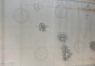
Sold3 maps: Civil War map [c1861], 2 isothermal chart[United States]. 3 Maps. ++ Isothermal Chart: Of The Region North of the 36th Parallel &c.&c. between the Atlantic & Pacific Ocean. Compiled by Isaac I. Stevens, Governor of Washington Territory. MapSee Sold Price
Sold3 US Maps[United States]. 3 Maps. ++ Isothermal Chart: Of The Region North of the 36th Parallel &c. &c. between the Atlantic & Pacific Ocean. Compiled by Isaac I. Stevens, Governor of Washington Territory. MapSee Sold Price
SoldSouthern Atlantic Sea ChartCarta General del Oceano Atlantico Meridional,sea chart for the southern Atlantic and Pacific oceans, from the west coast of Africa to the Galapagos Islands, with inset chart of the mouth ofSee Sold Price
SoldTHOMAS CONDER - Various Charts of Islands in theTHOMAS CONDER - United Kingdom 1746 - 1831 - Book JOHN HAMILTON MOORE - United Kingdom 1738 - 1807 - Various Charts of Islands in the Atlantic & Pacific Oceans. 1782 Copper engravings Signed, dated anSee Sold Price
Braddock Mead, Chart of North and South AmericaTitle: A Chart of North and South America, including the Atlantic and Pacific Oceans, with the nearest Coasts of Europe, Africa, and Asia.Cartographer: Braddock Mead (c.1685-1757) Copper plate engravSee Sold Price
Bellin: Chart of the Straits of Magellan, 1753Carte Reduite du Detroit de Magellan Bellin's superbly detailed map of the most important natural passage between the Atlantic and Pacific Oceans, the Straits of Magellan, from the atlas of Prevost d'See Sold Price
SoldJohn Green Chart of Americas 4th issue 1775Heading: Author: [Green, John, pseud. of Braddock Mead] Title: A Chart of North and South America, Including the Atlantic and Pacific Oceans, with the nearest Coasts of Europe, Africa, and Asia PlaceSee Sold Price
SoldJohn Green Chart of Americas 2nd issue 1763Heading: Author: [Green, John, pseud. of Braddock Mead] Title: A Chart of North and South America, Including the Atlantic and Pacific Oceans, with the nearest Coasts of Europe, Africa, and Asia PlaceSee Sold Price
Wall Map of North American by Braddock MeadeA Chart of the North and South America including the Atlantic and Pacific Oceans with the nearest coasts of Europe, Africa and Asia... Engraved map with original hand color on six sheets, 3 parts, joiSee Sold Price
Bellin: Map of Le Maire Strait/Tierra del Fuego, 1753Carte du Detroit de le Maire Bellin's beautifully rendered map of a key passage between the Atlantic and Pacific Oceans, the Le Maire Strait between Tierra del Fuego and Staten Island. The chart incluSee Sold Price
Bellin: Le Maire Strait/Tierra del FuegoReserve Reduced! Bellin's beautifully rendered map of a key passage between the Atlantic and Pacific Oceans, the Le Maire Strait between Tierra del Fuego and Staten Island. The chart includes good coaSee Sold Price
SoldThe Times 1895 Mixed Lot of 5 MapsIncl Isothermal and Wind Chart, West Africa, Caucasus, Religions of the World, and Atlantic Ocean. Lithograph Maps Published 1895, London for "The Times Atlas" Paper Size: 16 x 10.5 inch (41 x 27cm) aSee Sold Price
The Times 1895 Mixed Lot of 5 MapsIncl Isothermal and Wind Chart, West Africa, Caucasus, Religions of the World, and Atlantic Ocean. Lithograph Maps Published 1895, London for "The Times Atlas" Paper Size: 16 x 10.5 inch (41 x 27cm) aSee Sold Price
SoldMAPS, Pacific Ocean, U.S. NavyPacific Ocean. U.S. Navy/Andriveau-Goujon, [Lot of 2] Naval Chart of the Pacific and Western Atlantic [and] Oceanie, 1860-1901 (circa). This lot contains two maps focused on colonial ownership in theSee Sold Price
SoldBellin (J N) South Atlantic chartBellin (Jacques Nicolas) Carte Reduite de l'Ocean Meridional,chart of the South Atlantic, showing all but the northern tip of South America, including the Pacific coast, the south west coast oSee Sold Price
Faden: Antique Sea Chart Map of Atlantic Ocean, 1807Title/Content of Map: A Chart of the Atlantic or Western Ocean . . . Wherein is delineated the Track of his Majesty's Fleet, Commanded by the late Viscount Nelson . . .Date Printed: 1807 Cartographer:See Sold Price
Thomson: Antique Chart Map of North Atlantic Ocean 1817Chart of the North Atlantic Ocean [and Gulf Stream] with tracks of the shipping to West Indies, North America &c.' A large and fascinating chart of the North Atlantic Ocean, showing the trade shippingSee Sold Price
Antique Sea Chart Map of South Atlantic Ocean, 1914Title/Content of Map: 'The South Atlantic Ocean; Inset Callao & Lima; Valparaiso; Rio de Janeiro; Cape Town; Rio de La Plata; Buenos Ayres; South African Ports; Port Natal' South Atlantic Ocean sea chSee Sold Price
SoldAntique Nautical Ship's Map of Atlantic Ocean, 1882Map: Track Chart Norddentsher Lloyd, Bremen Date Printed: 1882 Cartographer: Anonymous Size: 15 x 7 Condition: Good Several vertical folds as issued. Somewhat browned. Right side partially glued to caSee Sold Price
(Maps and Charts, Atlantic Ocean), Carte Generale(Maps and Charts, Atlantic Ocean), Carte Generale de L'Ocean Atlantique ou Occidental, Paris: Depot General, 1786, 8th edition, double-page folio, hand colored in outline, with marginal tables, 620 xSee Sold Price
Sold(Maps and Charts, Atlantic Ocean), Jansson, Joanne(Maps and Charts, Atlantic Ocean), Jansson, Joannes, Mar de Nort, [Amsterdam, c. 1650], double-page folio with hand coloring, with German text to verso, 19 3/4 x 23 1/2 in., (dampstaining around edgesSee Sold Price
Sold(Maps and Charts, Atlantic Ocean), Des Barres, Jos(Maps and Charts, Atlantic Ocean), Des Barres, Joseph F. Wallet (1722-1824), The Atlantic Neptune, published for the use of the Royal Navy of Great Britain, Barre, Massachusetts: Barre Publishing CompSee Sold Price
EARLY 18TH C. DUTCH CHART OF PACIFIC OCEAN BY FREDERIK DE WIT (1629-1706) WITH CALIFORNIA AS ANThomaston Place Auction Galleries4.4(393)See Sold PriceFeb 24, 2024
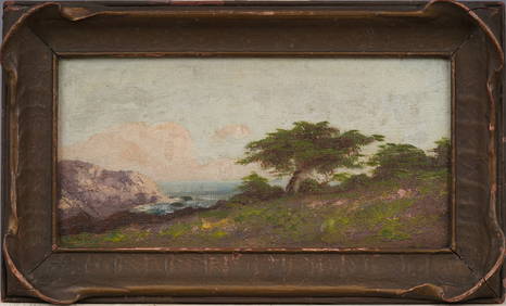
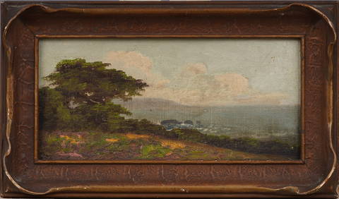
Antique California Coastal Beach Scene Pacific Ocean Framed American Impressionist Oil PaintingCurated Gallery Auctions4.6(131)See Sold PriceFeb 25, 2024
Antique California Coastal Beach Scene Pacific Ocean Framed American Impressionist Oil PaintingCurated Gallery Auctions4.6(131)See Sold PriceFeb 25, 2024
Wooden Star Of India Tall Model Ship 30"Weatherham Estate Treasures3.9(159)See Sold PriceFeb 28, 2024
Antique Natural Cream White Tridacna Squamosa Shell from S Pacific OceanNeo FineArts Inc4.4(13)See Sold PriceFeb 25, 2024
Hiroshi Sugimoto - North Atlantic Ocean, Cape Breton IslandSapphire Auction Gallery4(67)See Sold PriceMar 02, 2024
Mint Picture Postcard French Colonies Tahiti & Moorea Pacific Ocean IslandMynt Auctions4.6(697)See Sold PriceFeb 28, 2024
[LITHOGRAPHY]. [DIE-CUT TRADE CARDS]. “The Great Atlantic &...Potter & Potter Auctions4.6(545)See Sold PriceMar 07, 2024
[LITHOGRAPHY]. [DIE-CUT TRADE CARDS]. “The Gt. Atlantic & P...Potter & Potter Auctions4.6(545)See Sold PriceMar 07, 2024
[POSTCARDS] Twenty-eight Tourist Travel Vintage Postcards. ...Potter & Potter Auctions4.6(545)See Sold PriceMar 07, 2024
The Sparkling Pacific Ocean Mixed Media Original on canvas David Lloyd GloverArt Legacy Auctions4.5(223)See Sold PriceFeb 24, 2024
Wooden Star Of India Tall Model Ship 30"Weatherham Estate Treasures3.9(159)See Sold PriceMar 21, 2024
CHART: South Pacific Ocean / SOCIETY ISLANDS - WESTERN GROUP/ HUAHINE TO MAUPITI With theChurchill Galleries3.7(217)See Sold PriceFeb 26, 2024
Vintage Fleischmann HO Union Pacific Ocean View Car ARapid Estate Liquidators and Auction Gallery4.5(1.1k)See Sold PriceFeb 29, 2024
Vintage Fleischmann HO Union Pacific Ocean View Car BRapid Estate Liquidators and Auction Gallery4.5(1.1k)See Sold PriceFeb 29, 2024
HIROSHI SUGIMOTO, SOUTH PACIFIC OCEAN, TEARAI, 1991White Knight Auction, Inc4.7(252)See Sold PriceMar 03, 2024
Blancpain x Swatch Scuba Fifty Fathoms Pacific Ocean Gray Dial WatchBidhaus4.3(762)See Sold PriceMar 06, 2025


![3 maps: Civil War map [c1861], 2 isothermal chart (1 of 3)](https://p1.liveauctioneers.com/179/14187/4432492_1_x.jpg?height=282&quality=70&version=1193335524)


![[LITHOGRAPHY]. [DIE-CUT TRADE CARDS]. “The Great Atlantic &... (1 of 2)](https://p1.liveauctioneers.com/928/318880/171361052_1_x.jpg?height=282&quality=70&version=1707501302)
![[LITHOGRAPHY]. [DIE-CUT TRADE CARDS]. “The Gt. Atlantic & P... (1 of 2)](https://p1.liveauctioneers.com/928/318880/171361053_1_x.jpg?height=282&quality=70&version=1707501302)
![[POSTCARDS] Twenty-eight Tourist Travel Vintage Postcards. ... (1 of 1)](https://p1.liveauctioneers.com/928/318880/171361149_1_x.jpg?height=282&quality=70&version=1707501302)