India.- Wit (Frederick de) - Tabula Indiae Orientalisafter de Wit, by J. L'Huilier, engraved map of the East Indies, with hand-colouring, 460 x 570 mm., on laid paper, with watermark of an elephant, central vertical fold, handling creases, spotting andSee Sold Price
INDIA & EAST INDIES - WIT, Frederick de.INDIA & EAST INDIES - WIT, Frederick de. Tabula Indiæ Orientalis. (Amst., Frederick de Wit, 1662). (Ca. 45,5 x 56 cm). Attractive map depicting India, Southern China, the Philippines, the East IndiesSee Sold Price
Lotter map of India & Southeast Asia 1662Title: Tabula Indiæ Orientalis Author: De Wit, Frederick Description: Copper-engraved map, hand-colored in outline; colored pictorial cartouche. 46x57 cm. (18x22¼").De Wit's map of Southeast Asia anSee Sold Price
SoldDe Wit map of India & Southeast Asia 1662Heading: Author: Wit, Frederick de Title: Tabula Indiæ Orientalis Place Published: Amsterdam Publisher: Date Published: 1662 Description: Copper-engraved map, hand-coloredSee Sold Price
SoldFrederick De Wit, Dutch 1610-1698- ''Tabula IndiaeFrederick De Wit, Dutch 1610-1698- ''Tabula Indiae Orientalis'', publ. 1662; hand colour engraved map, 46x57cm: Sidney Hall, British 1788-1831- ''China'', publ. by Longman, Rees, Orme, Brown & Green,See Sold Price
SoldDe Wit Map of Southeast AsiaDE WIT, Frederick (1630-1706). Tabula Indiae Orientalis... Engraved map with original hand color in outline. Amsterdam, 1662. 21" x 24" sheet. This beautiful map of Southeast Asia was engraved by JoanSee Sold Price
SoldTabula Indiae Orientalis byFrederick de Wit Amsterdam, 1662, de Wit's attractive hand-colored map of Southeast Asia, engraved by Joannas Lhulier, this map served as a prototype for Speed's map of the East Indies, cartouche withSee Sold Price
SoldDe Wit (Frederick) - Tabula Indiæ Orientalis,South East Asia and the Indian subcontinent, title cartouche with native costume figures, upper right, engraved map with original hand-colouring, 460 x 565mm., reapired splitting on central vertical fSee Sold Price
Soldde Wit: Map of Southeast Asia, 1670Map: Tabula Indiae Orientalis Cartographer: Frederick De Wit Place & Date: Amsterdam / 1670 Size: 22 1/4" x 18 1/4" Condition: light overall age-toning A highly decorative and beautifully colored lateSee Sold Price
SoldWit (Frederick de) Holsatiæ Tabula GeneralisWit (Frederick de) Holsatiæ Tabula Generalis,northern Germany, with decorative title cartouche, engraved map with full original hand-colouring, 502 x 615mm., central vertical fold, a few repaiSee Sold Price
Wit, Frederick de. Nova Orbis Tabula in LucemWit, Frederick de Nova Orbis Tabula in Lucem 1680 Copperplate engraving; coloured Printed area: 57.6 x 48.8 cm; 22.4 x 19.2 in de Wit's striking double hemisphere map of the World is one of the most aSee Sold Price
Wit (Frederick de) Nova Orbis TabulaWit (Frederick de) Nova Orbis Tabula, in lucem edita,engraved map with full orignal hand-colouring, 480 x 570mm., central vertical fold, a little creasing adjacent to fold, uneven damp-staininSee Sold Price
Wit (Frederick de) Pars Flandriæ OrientalisWit (Frederick de) Pars Flandriæ Orientalis,north sea coast of Belgium, with decorative title cartouche, engraved map with original hand-colouring in outline, 390 x 490mm., central vertical foSee Sold Price
Wit (Frederick de) - Nova Orbis Tabula, In Lucem1st state double-hemisphere world", with 2 polar inset spheres, and elaborate allegorical scenes depicting the four seasons in the corners, engraved map with hand-colouring, 470 x 575mm., repaired splSee Sold Price
SoldWit (Frederick de) - Nova Orbis Tabula, In Lucem2nd state", 2nd plate double-hemisphere world, with 2 polar inset spheres, and elaborate allegorical scenes depicting the four seasons in the corners, with the addition of an engraved border and puttiSee Sold Price
Wit (Frederick de) Comitatus FlandriæWit (Frederick de) Comitatus Flandriæ Tabula; Pars Flandriæ occidens; Flandria Gallica, together 3 engraved maps of Belgium with original outline hand-colouring, decorative cartouche, 460 x 56See Sold Price
SoldDE WIT, FREDERICK. Tabula Tartariae et Majoris PartisDE WIT, FREDERICK. Tabula Tartariae et Majoris Partis Regni Chinae. Double-page engraved map of northeast Asia including Tartary, Siberia, China and Japan. 21x25 inches sheet size, wide margins; excelSee Sold Price
SoldDe Wit Map of AfricaTotius Africa Accuratissima Tabula. Frederick de Wit (1629/1630-1706). Engraved map with original hand color. Amsterdam, c. 1660. 19 1/4 x 23 inches visible, 24 3/4 x 28 1/2 inches framedSee Sold Price
Frederick de Wit "Accuratißima Galliae Tabula …". 2nd hFrederick de Wit "Accuratißima Galliae Tabula …". 2nd half 17th cent. Engraving, altkoloriert, auf Bütten. In der Platte bezeichnet "Amstelodami ex officina Frederici de Wit cum Privil. D.D.Ord.HoSee Sold Price
MAP - Southwestern Netherlands. De WitSouthwestern Netherlands. Frederick de Wit, Comitatus Zelandiae Tabula, 1680 (circa). Hand Color. This handsome map of Zeeland details the islands of Walcheren, Beveland, Schouwen, and Tholen within tSee Sold Price
Antique Map of India's Mughal Empire: Frederick de Wit's 1730 EditionTitle: Antique Map of India's Mughal Empire: Frederick de Wit's 1730 Edition Date/Period: 1730 Materials: Copperplate engraved, hand colored Size: 20 1/3 x 16 1/3” Discover the intricacies of InSee Sold Price
Map of India's Mughal Empire. Frederick de Wit's 1730 EditionTitle: Map of India's Mughal Empire. Frederick de Wit's 1730 Edition Date/Period: 1730 Materials: Copperplate engraved, hand colored Size: 20 1/3 x 16 1/3” This map, published by Covens & MortieSee Sold Price
SoldCounty of Flanders. Frederick De Wit.Comitatus Flandriae Tabula In Lucem Maker: De Wit, Frederick. Origin: Amsterdam, 1680. Medium: Original copper engraving with early hand-coloring. Sheet size: 20 1/4 x 24 3/4 in. No Reserve: This lotSee Sold Price
SoldRARE MAPDe Wit, Frederick, 'Comitatus Flandriae Tabula in lucem edita a Frederico De Wit Amsterodami', published in Amsterdam, 1680, original hand-coloring, trimmed to edge, 17 7/8" x 21 1/2", shrinkwrapped oSee Sold Price
Extremely early Ganesh from India, Afghanistan, or Pakistan.The Buddha Gallery4.4(29)See Sold PriceMar 13, 2024
EARLY 18TH C. DUTCH CHART OF PACIFIC OCEAN BY FREDERIK DE WIT (1629-1706) WITH CALIFORNIA AS ANThomaston Place Auction Galleries4.4(389)See Sold PriceFeb 24, 2024
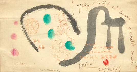
Joan Miró (Spanish, 1893-1983) - Joyeux Noël, Vœux de Joan, Pilar et DolorèsFreeman's | Hindman4.5(158)See Sold PriceFeb 27, 2024
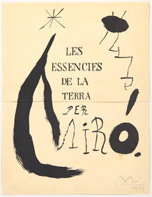
Joan Miró (Spanish, 1893-1983) - Projet pour la Page de Titre de l’Album 'Les EssenciesFreeman's | Hindman4.5(158)See Sold PriceFeb 27, 2024
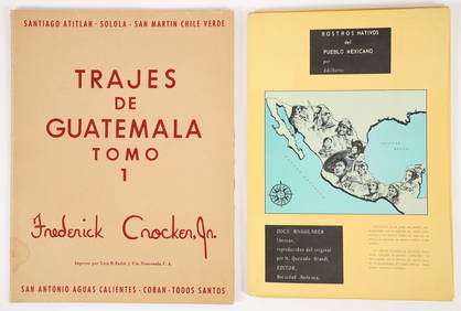
2 color portfolios Natives of Mexico and GuatemalaConcept Art Gallery4.7(509)See Sold PriceMar 06, 2024
Unique collection of 18 carte de visites of Queen Victoria’s familyJasper524.5(9.8k)See Sold PriceFeb 27, 2024
13 pcs Vintage Decorative Assortment. 5x De Simone Italian Pottery, 2 Bells & 3 Kings Statuettes.Crawford Family Auctions LLC4.5(119)See Sold PriceMay 25, 2024