SoldFive Small Town Idaho Mining Stock Certificates 107470Lot of 5 different. Included: Great Western Mining Company, Ltd. (Burke, 1906, elk vignette); Panhandle Mining & Milling Co., Ltd. (Wardner, 1899, mining vignette); Salmon River Mining & Milling Co. (See Sold Price
SoldIdaho Mining Stocks with Unusual Names 107539Lot of 5 different. Included: Treasure Vault Mining Company, Ltd. (1923, lion head vignette); Shakespeare Mining Company, Ltd. (1907, mining vignette); The Swastika Mining & Milling Co. (1909, miningSee Sold Price
SoldFive Small-town Idaho Mining Stock Certificates 107467Lot of 5 different. Included: Hartwig Mining Company (Pollock, 1905, mining vignettes); Clipper Gold Mining & Milling Co., Ltd. (Hailey, 1917, eagle vignette); Carney Copper Company, Ltd. (Mullan, 191See Sold Price
SoldNorth American City and Industry Works on Paper, Lot ofNorth American City and Industry Works on Paper, Lot of Five Four maps and one industrial landscape drawing, including: American, 19th century. Bonanza Bar / Argile Mining District / Idaho, u.c. A scaSee Sold Price
SoldMILITARY MAP CASE LOT OF 5MILITARY MAP CASE LOT OF 5 Era / Conflict: WWII Country: MixedSee Sold Price
SoldPhilip, George C1900 Lot 5 Maps. Australia, NZ PacificLithograph Maps Published C1900, London for "Philips' New Handy General Atlas of the World" by George Philip. Paper Size: 14.5 x 10.5 inch (37 x 27cm) Good ConditionSee Sold Price
SoldMining and Geological Maps. Lot of 31 Maps.Mining and Geological Maps. Lot of 31 Maps. Edite dalla Librairie Polytchnique Ch. Béranger, fine dell’800 - inizi del 900 Il lotto si compone di15 mappe minerarie e geologiche a colori inSee Sold Price
SoldBartholomew, John 1922 Lot 5 Maps of Britain & IrelandIncl British Isles Political, British Isles Railways, Scotland South, Scotland North, Ireland North Section, Ireland Southern Section. Large Lithograph Maps Published 1922 by The Times, London for "ThSee Sold Price
SoldWWII D-DAY TOP SECRET NEPTUNE ASSAULT FORCE O MAPWWII D-DAY TOP SECRET NEPTUNE ASSAULT FORCE O MAP From Rear Admiral George B.H. Stallings Archive; WWII US Armed Forces, D-Day Top Secret Neptune maps set. Lot of 5 maps stapled together to form a panSee Sold Price
SoldWASHINGTON TERRITORY MAPS, 1870Maps1870, “Washington Territory” Maps 1870, Lot of 5, Extremely Rare, Massive Four-Sheet Map of “Washington Territory,” Choice Very Fine. Running approx. 32.75” x 24&rdquSee Sold Price
SoldLOT (5) ENGRAVED MAPS INCLUDING MARTINIQUE, FROM PETITLOT (5) ENGRAVED MAPS INCLUDING MARTINIQUE, FROM PETIT ATLAS NATIONAL, 19TH CENTURY, 10 X 8"; WINDWARD ISLANDS (ST. LUCIA, ST. VINCENT AND BARBADOS), T. KITCHIN, 18TH CENTURY, 10 1/4 X 8"; ANTILLES ORSee Sold Price
SoldSouth America C1830-1890s Lot of 5 MapsIncl South America Continent, Brazil, and Columbia/Venezuela/Ecuador/Peru/Bolivia. Three Lithograph Maps and One Hand Colored Copper Engraved Map Published C1835, London for "A Complete and UniversalSee Sold Price
SoldBartholomew, John 1922 Lot of 5 Maps of the OceansIncl North Atlantic, Indian Ocean, North Pacific, South Pacific and South Atlantic. Large Lithograph Maps Published 1922 by The Times, London for "The Times Survey Atlas of the World" Maps by John GeoSee Sold Price
SoldEgypt & Arabia 19th Cent. Lot of 5 MapsLot of 4 19th Cent Lithographed and Engraved Maps. Examples by SDUK, Weller/Weekly Dispatch, William Collins, and Johnston. Together with a large 20th Cent. Admiralty Chart of the Red Sea, published 1See Sold Price
SoldStieler, Adolph 1905 Lot of 5 Maps. AustraliaLithograph Maps Published 1905 by Justus Perthes, Gotha for "Stielers Hand-Atlas" by Adolf Stieler. Centre fold as published. Paper Size: 18.5 x 15.5 inch (48 x 40cm) Good ConditionSee Sold Price
SoldBlackie & Weller 1882 Lot of 5 Maps of AfricaIncl "Africa" Continent "Marocco Algeria and Tunis" Egypt/Nubia/Abyssinia "Western Africa" and "South Africa" Lithograph Maps Published 1882 by Blackie & Son, London for "The Comprehensive Atlas & GeoSee Sold Price
SoldCentral and South America 1903 Lot of 5 MapsLithograph Maps Published 1903 by Adam & Charles Black, Edinburgh & London for "Encyclopaedia Brittannica" Tenth Edition. Centre fold as published. Paper Size: 16 x 11.5 inch (41 x 29cm) Good ConditioSee Sold Price
SoldAfrica 1903 Lot of 5 MapsLithograph Maps Published 1903 by Adam & Charles Black, Edinburgh & London for "Encyclopaedia Brittannica" Tenth Edition. Centre fold as published. Paper Size: 16 x 11.5 inch (41 x 29cm) Good ConditioSee Sold Price
SoldThe Times 1895 Mixed Lot of 5 MapsIncl Isothermal and Wind Chart, West Africa, Caucasus, Religions of the World, and Atlantic Ocean. Lithograph Maps Published 1895, London for "The Times Atlas" Paper Size: 16 x 10.5 inch (41 x 27cm) aSee Sold Price
SoldStieler, Adolph 1905 Lot of 5 Maps. Spain & PortugalLithograph Maps Published 1905 by Justus Perthes, Gotha for "Stielers Hand-Atlas" by Adolf Stieler. Centre fold as published. Paper Size: 18.5 x 15.5 inch (48 x 40cm) Good ConditionSee Sold Price
SoldButler, George 1874 Lot of 5 Maps of EuropeIncl Holland/Belgium, Sweden/Norway/Denmark, Russia, Italy, Turkey in Europe. Lithograph Maps Published 1874, London for "The Public School Atlas of Modern Geography" by Rev. George Butler. Paper SizeSee Sold Price
SoldBlackie & Weller 1882 Mixed Lot of 5 MapsIncl Japan, France, Central Europe, Spain and Portugal, Brazil. Lithograph Maps Published 1882 by Blackie & Son, London for "The Comprehensive Atlas & Geography of the World" by W. G. Blackie. Maps bySee Sold Price
SoldStieler, Adolph 1905 Lot of 5 Maps of ItalyLithograph Maps Published 1905 by Justus Perthes, Gotha for "Stielers Hand-Atlas" by Adolf Stieler. Centre fold as published. Paper Size: 18.5 x 15.5 inch (48 x 40cm) A few margin tears, images fineSee Sold Price
SoldBartholomew, John 1922 Lot of 5 Maps Egypt & Holy LandIncl Egypt and The Nile, Lower Egypt, Asia Minor/Syria/Mesopotamia, Palestine and Persia. Large Lithograph Maps Published 1922 by The Times, London for "The Times Survey Atlas of the World" Maps by JoSee Sold Price
JOHN FULTON Coke Coal Mining Rare c1895 1st Edition TreatiseLuis Porretta Fine Arts4.3(10)See Sold PriceMar 02, 2024
5 Dollars - Elizabeth II Map of North AmericaWeatherham Estate Treasures3.9(157)See Sold PriceMar 07, 2024
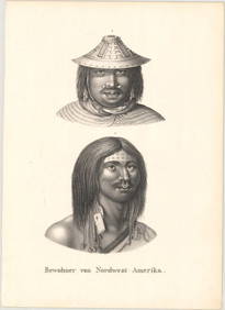
Antique Native American 5 Piece Lot: Deerskin Jacket & Pants, Rug, Drum, Michigan Map & Mule DeerHoller and Hammer4.5(47)See Sold PriceFeb 24, 2024
Lot of 12 Vintage 1954 General Mills Promotional Tin License PlatesBodnar's Auction Sales4.6(609)See Sold PriceMar 28, 2024
18th century MAP of ARMENIA GEORGIA NATOLIA BLACK SEA ASIA MINOR antiqueJasper524.5(9.8k)See Sold PriceFeb 27, 2024
1636 MAP of SWITZERLAND DAS WIFISPURGERGOU antique 15 by 19"Jasper524.5(9.8k)See Sold PriceFeb 27, 2024
Geographical, Statistical, and Historical Map of the Leeward Islands.Jasper524.5(9.8k)See Sold PriceFeb 27, 2024
A23 United States in the Caribbean Denoyer-Geppert Social Science MapsJasper524.5(9.8k)See Sold PriceFeb 27, 2024
Lot Of Mid Century Ephemera, Including Maps & 1957 License PlatesClark's Auction Company4.6(433)See Sold PriceMar 03, 2024
Goode, George Brown 1884 Lot of 4 Natural History & Meteorology MapsAlbion Auctions4.6(336)See Sold PriceMar 01, 2024
Rees & Macpherson 1820 Lot of 6 Ancient Geography MapsAlbion Auctions4.6(336)See Sold PriceMar 01, 2024
Vintage Australia Airplane Ashtray [Kangaroo]Grant Zahajko Auctions, LLC4.8(1k)See Sold PriceMar 06, 2024


![Vintage Australia Airplane Ashtray [Kangaroo] (1 of 7)](https://p1.liveauctioneers.com/5755/320282/172113950_1_x.jpg?height=282&quality=70&version=1708463029)