ATLAS of ANTIENT GEOGRAPHY by SAMUEL BUTLER 1843John McInnis Auctioneers,LLC4.6(502)See Sold PriceFeb 24, 2024
18TH C. ANTIQUE MAP: FRENCH & INDIAN WAR, FRAMEDThomaston Place Auction Galleries4.4(386)See Sold PriceFeb 24, 2024
Rand McNally Railroad Map Cabinet w/ 21 Railroad MapsRail & Road Auctions4.6(165)See Sold PriceMar 08, 2024
Keith Haring - Ink on New York Map, Best Buddies, Inscribed, Signed, and DatedSapphire Auction Gallery4(67)See Sold PriceMar 02, 2024
LATE 17TH C. FRENCH MAP OF THE NEW WORLD BY ALEXIS-HUBERT JAILLOT (1632-1712)Thomaston Place Auction Galleries4.4(386)See Sold PriceFeb 24, 2024
Central Railroad of New Jersey Map of Sandy Hook Route-ca. 1903JM Hobby Supply and Railroad Artifact Auctions4.4(126)See Sold PriceFeb 24, 2024
Lot of Six Mixed Atlas Box Cars-HO Scale-New in BoxJM Hobby Supply and Railroad Artifact Auctions4.4(126)See Sold PriceFeb 25, 2024
Rand McNally/Santa Fe Railroad Map of Iowa-1912JM Hobby Supply and Railroad Artifact Auctions4.4(126)See Sold PriceFeb 24, 2024
NICOLAES VISSCHER (NETHERLANDS, 1618-1709) MAP OF THE NEW WORLDThomaston Place Auction Galleries4.4(386)See Sold PriceFeb 24, 2024
17TH C. WORLD MAP BY NICOLAES VISSCHER (NETHERLANDS, 1618-1709)Thomaston Place Auction Galleries4.4(386)See Sold PriceFeb 24, 2024
Lot of Six Mixed Atlas Cabooses-HO Scale-New in BoxJM Hobby Supply and Railroad Artifact Auctions4.4(126)See Sold PriceFeb 25, 2024
SoldHolland & Pownall Map of New York...Holland, Major Samuel (1728-1801) & Pownall, Thomas (1722-1805). The Provinces of New York and New Jersey; with Part of Pensilvania, and the Province of Quebec. Engraved map with orignal hand color. LSee Sold Price
SoldHolland (Samuel) Major & Pownall (Thomas)Holland (Samuel, Major) & Pownall (Thomas) The Provinces of New York, and New Jersey, with part of Pensilvania and the Province of Quebec. Drawn By Major Holland, Surveyor General, of the Northern DisSee Sold Price
SoldRare - 1768 Holland - Jeffreys Map of New York and NewThe rarest and earliest state of a seminal map. The Provinces of NEW YORK and NEW JERSEY with part of PENSILVANIA, and the Governments of TROIS RIVIERES, and MONTREAL: drawn by Capt. Holland. / A ChorSee Sold Price
SoldCAPTAIN SAMUEL HOLLAND HAND ENGRAVED MAP, 1775CAPTAIN SAMUEL HOLLAND, HAND ENGRAVED MAP OF NEW YORK, NEW JERSEY AND PARTS OF PENNSYLVANIA, 1775 H 53" W 21" In two sheets. Reveals provinces of New York and New Jersey with a part of Pensilvania andSee Sold Price
Rare 1723 Maps of New York Samuel HollandRare 1723 Maps of New York - Samuel Johannes Holland (1728 – 28 December 1801) was a Royal Engineer and first Surveyor General of British North America. Early Map of New York, Connecticut, New JerseSee Sold Price
SoldHOLLANDl. Map - New York and New Jersey, 1775HOLLAND, Samuel. "The Provinces of New York and New Jersey with part of Pennsylvania, and the Province of Quebec." London: Robt Sayer & John Bennett, 1775. This upper section with three insets: "A ChaSee Sold Price
SoldMajor Holland A Plan of the City of New York 1776Major Holland, "A Plan of the City of New York," engraved map from the 1863 version by G. Hayward. The map was originally from 1776 and is considered one of the earliest and most iconic maps of LowerSee Sold Price
Sold21 x 52 inch engraved and hand colored map of Providenc21 x 52 inch engraved and hand colored map of Providences of New York New Jersey With Part of Penn and and Providence of Quebec Drawn by Major Holland Published London 1776See Sold Price
SoldMap-New York & New Jersey at start of RevolutionTitle: The Provinces of New York and New Jersey; with Part of Pensilvania, and the Province of Quebec. Drawn by Major Holland... Corrected and Improved... by Govern. Pownall... Author: Sayer & BennettSee Sold Price
SoldHolland, Major Samuel51. Holland, Major Samuel.The Provinces of New York, and New Jersey; with part of Pensilvania, and the Province of Quebec. Engraved folding map of the colonial northeast on two sheets. 54 x 21-1/2 incSee Sold Price
SoldPair of MapsPair of Maps.A Chart of the Mouth of the Hudson's River from Sandy Hook to New York; Sight: 25 1/2" x 20". The Provinces of NY & NJ with part of PA and the Province of Quebec. Drawn by Major Holland.See Sold Price
Sold* [BRITISH AERONAUTICS, 19th-CENTURY].* [BRITISH AERONAUTICS, 19th-CENTURY]. HOLLAND, Robert; MONCK, Mason. Account of the Late Aeronautical Expedition from London to Weilburg. New York: Theodore Foster, 1837. Modern calf-backed marbled bSee Sold Price
SoldArctic Exploration...c. 500 b.c. to 1915: AnHeading: Author: Holland, Clive Title: Arctic Exploration and Development c. 500 b.c. to 1915: An Encyclopedia Place Published: New York Publisher:Garland Date Published: 1994 DescriptSee Sold Price
SoldVOL 1,3-7,9,10 DOCUMENTS RELATIVE TO THE HISTORY OF THEVOL 1,3-7,9,10 DOCUMENTS RELATIVE TO THE HISTORY OF THE STATE OF NEW YORK; PROCURED IN HOLLAND, ENGLAND AND FRANCE, BY JOHN ROMEYN BRODHEAD, ESQ, 1853-1856, FOLD OUT MAP, SPINES AND COVERS WORN, AS PISee Sold Price
SoldMap New York, Pennsylvania New Jersey, c.1840Map New York, Pennsylvania New Jersey, c.1840, 25.5" x 22.5" in frame, 23" x 20" without frameSee Sold Price
Sold10 Maps: New York street grid, views, US, MD[New York/Maryland/US] 10 Maps. 8 1/8 x 9 3/4 in. to 17 7/8 x 27 1/2 in. Sold with all faults. ++ MAP OF THE CITY OF NEW-YORK 1852. Folding map from an annual edition of Valentine’s Manual. ++ PARTSee Sold Price
SoldLarge map, New York City's UWS, 1879Large map, New York City's UWS, 1879, "West End Plateau of New York" by Herman K. Viele, City Surveyor, printed by Johnson & Pratt, New York, 1879, framed under acrylic, with 25-page booklet in pocketSee Sold Price
Sold19th c. Map New York City19th c. "Map Of New York And Its Vicinity, New York 1863". Published by S.D. Tildern. 63 1/2" x 63 1/2". Some damage.See Sold Price
Three Borough Map New York, 1950Item: Three Borough Map New York "Map of the Bronx, Queens and Brooklyn" Norman's Simplified Maps Date: 1950 Size: 16.75 x 17 inches Please note that this lot has a reserve. When you leave a bid in adSee Sold Price
Sold[Map] New York City[Map] New York City , 1846, drawn by D.H. Burr, pub. Homans & Ellis, , linen backed and lacquered, 12 5/8 in. x 10 3/8 in Provenance: Property deaccessioned from the Louisiana State Museum, proceeds tSee Sold Price
SoldLarge framed map, "New York City North of 93rd Street",Large framed map, "New York City North of 93rd Street", Colton's New Map of the City and County of New York Including Extensions North of the Harlem River, published by G.W. and C.B. Colton & Co.'s sSee Sold Price
SoldJacques Nicolas Bellin Map. New York and PennsylvaniaJacques Bellin (French, 1703-1772). Hand colored engraved map. Carte De Nouvelle, Angleterre. Nouvelle York, et Pensilvanie. Includes Eastern Pennsylvania along with New York and New England. UnframedSee Sold Price
SoldM. Dripps 1860 Map New York City County & Vacinity By M. DrippsM. Dripps 1860 Map New York City County & Vacinity By M. Dripps 22.5" x 30"See Sold Price
SoldAntique Hand Colored Engraved Map NEW YORK STATE SmithDetails: This nicely hand-colored engraved map of New York State was designed by J. Calvin Smith and published by J. Disturnell circa 1852. Featuring insets of New York City and the St. Lawrence RiveSee Sold Price
1892 Adams and Bowles New Road Map of the State of New YorkJM Hobby Supply and Railroad Artifact Auctions4.4(126)See Sold PriceFeb 24, 2024
Crams Railroad Map of New York-1881JM Hobby Supply and Railroad Artifact Auctions4.4(126)See Sold PriceFeb 24, 2024
Crams Township and Railroad Map of New York-1890JM Hobby Supply and Railroad Artifact Auctions4.4(126)See Sold PriceFeb 24, 2024
Erie Railway Tourist Book/Magazine-1874JM Hobby Supply and Railroad Artifact Auctions4.4(126)See Sold PriceFeb 24, 2024
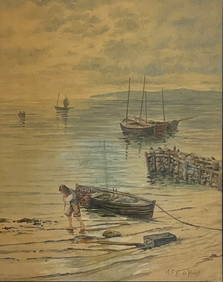
MAURITZ FREDERIK HENDRICK DE HAAS (New York/Holland, 1832-1895), Coastal scene of boats working in aEldred's4.7(409)See Sold PriceFeb 27, 2024
George Hayward - Map of the City of New York 1854Dane Fine Art Auctions4.4(494)See Sold PriceMar 07, 2024
Vintage County Map Of NY State Plate EngravingThe Benefit Shop Foundation Inc.4.3(2.9k)See Sold PriceFeb 28, 2024
1855 Map of New York & Erie Railroad and 1917 Trespassing On Railway Property Is A MisdemeanorRail & Road Auctions4.6(165)See Sold PriceMar 07, 2024
Keith Haring - Ink on New York Map, Best Buddies, Inscribed, Signed, and DatedSapphire Auction Gallery4(67)See Sold PriceMar 02, 2024
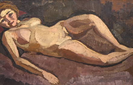
Roger de la Fresnaye (French, 1885-1925) - Femme Nue CouchéeFreeman's | Hindman4.5(158)See Sold PriceFeb 27, 2024
1867 Map of the Railroads of The State of New YorkRail & Road Auctions4.6(165)See Sold PriceMar 08, 2024
1919 The Story of The Great War by Official Sources Volumes 1,2,3,8.North American Artifact Auctions4.6(182)See Sold PriceApr 20, 2024
Keith Haring Artwork Signed on a Shell Oil New York Road Map 18 in. x 24 in.Donny Malone Auctions4.5(1.7k)See Sold PriceMar 04, 2024
Group of Vintage travel maps and bookletsBaker's Antiques and Auctions3.3(462)See Sold PriceFeb 25, 2024
Mauritz Frederik Hendrick De Haas (1832 - 1895) New York/ HollandCutler Bay Auctions4.5(168)See Sold PriceFeb 29, 2024
Black and white map of part of New York City (mostly Manhattan)Proverde Auctions4.3(3)See Sold PriceFeb 28, 2024
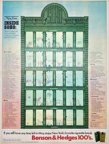
Map Inside Soho - Manhattan - New York Magazine 1974Proverde Auctions4.3(3)See Sold PriceFeb 28, 2024
Laminated Unique Media New York City MapRapid Estate Liquidators and Auction Gallery4.5(1.1k)See Sold PriceFeb 29, 2024


![* [BRITISH AERONAUTICS, 19th-CENTURY]. (1 of 2)](https://p1.liveauctioneers.com/197/136865/69466143_1_x.jpg?height=282&quality=70&version=1550699608)


![[Map] New York City (1 of 1)](https://p1.liveauctioneers.com/268/180010/90586232_1_x.jpg?height=282&quality=70&version=1600794544)